›››
Croatia — Media Gallery
20 items available (flags, maps, photos)
Photos
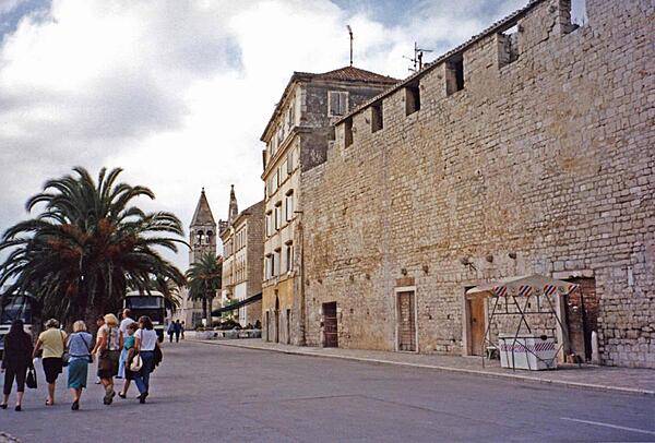
Outside the walls of historic Trogir. The town's 2,300 years of continuous urban tradition (Greek, Roman, Venetian, Habsburg) have left a fascinating and unique concentration of palaces, churches, towers, and fortifications. In 1997, Trogir was inscribed onto the UNESCO list of World Heritage Sites.
Outside the walls of historic Trogir. The town's 2,300 years of continuous urban tradition (Greek, Roman, Venetian, Habsburg) have left a fascinating and unique concentration of palaces, churches, towers, and fortifications. In 1997, Trogir was inscribed onto the UNESCO list of World Heritage Sites. • CIA World Factbook • 2020
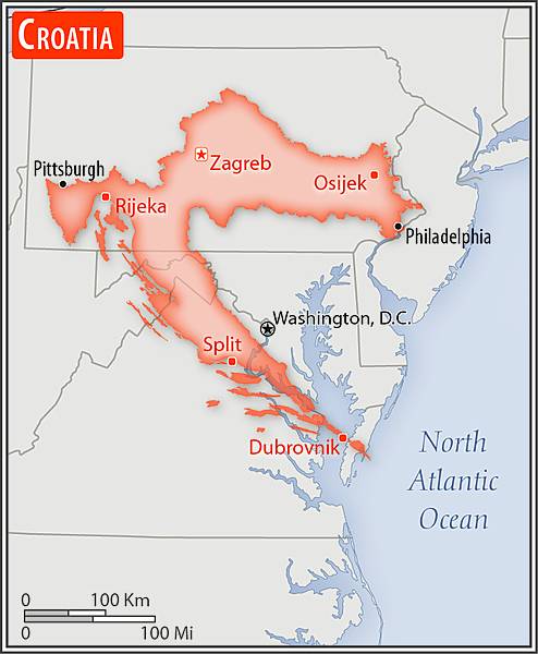
Area comparison map
Area comparison map • CIA World Factbook • 2020
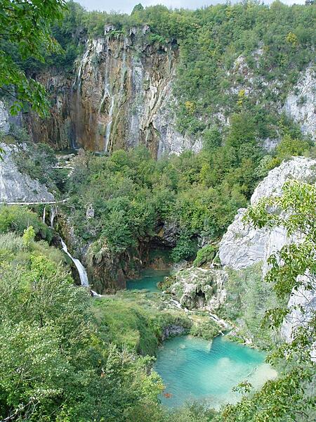
A view in Plitvice Lakes National Park looking down into the gorge where the largest waterfalls in the park - draining from one lake to the next - are located. The park has been added to the UNESCO World Heritage Register.
A view in Plitvice Lakes National Park looking down into the gorge where the largest waterfalls in the park - draining from one lake to the next - are located. The park has been added to the UNESCO World Heritage Register. • CIA World Factbook • 2020
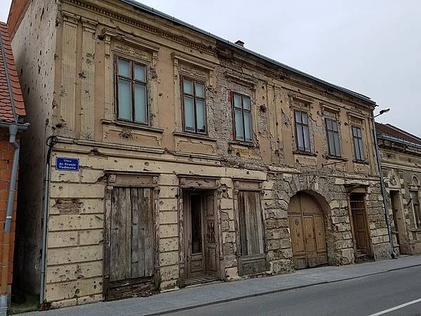
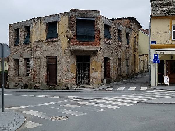
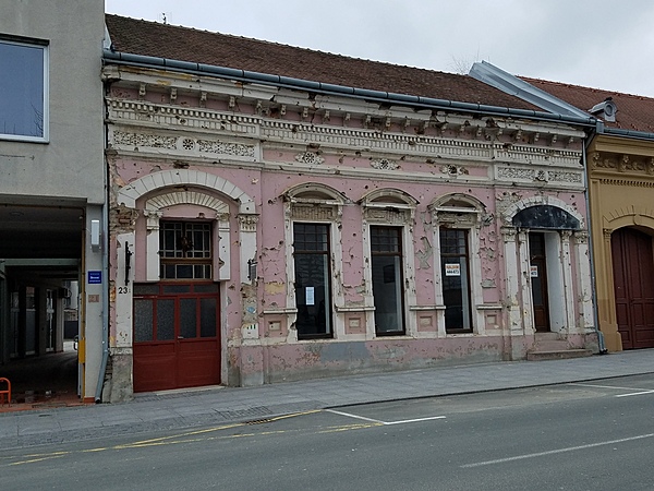
Vukovar, on the confluence of the Vuka and Danube Rivers, is Croatia's largest river port. The city was almost completely destroyed during an 87-day siege by Yugoslav forces and Serbian militias from August to November 1991 after Croatia declared its independence from Yugoslavia. The city has been largely rebuilt but certain buildings remain unrepaired as reminders of the fighting that resulted in 2,000 defenders killed, several hundred soldiers and civilians massacred after the city fell, and at least 20,000 inhabitants expelled. The fighting for Vukovar has been described as the worst in Europe since World War II; the city's population today is only about 60% of its pre-war total.
Vukovar, on the confluence of the Vuka and Danube Rivers, is Croatia's largest river port. The city was almost completely destroyed during an 87-day siege by Yugoslav forces and Serbian militias from August to November 1991 after Croatia declared its independence from Yugoslavia. The city has been largely rebuilt but certain buildings remain unrepaired as reminders of the fighting that resulted in 2,000 defenders killed, several hundred soldiers and civilians massacred after the city fell, and at least 20,000 inhabitants expelled. The fighting for Vukovar has been described as the worst in Europe since World War II; the city's population today is only about 60% of its pre-war total. • CIA World Factbook • 2020
Radnicki Dom (Workers' Hall), formerly the Grand Hotel, is one of Vukovar's most famous architectural landmarks. From its opening in 1897 until its wartime destruction in 1991, it was the social and cultural center for the town's diverse population. The impetus to rebuild Workers' Hall came from the European Parliament, as part of an initiative to encourage post-conflict recovery and reconciliation through the restoration of architectural monuments destroyed in the 1991-95 war. The faithful reconstruction of the exterior, roof, and basement took two years (May 2011-April 2013) and cost €1.64 million. Fund-raising continues to rebuild the interior, estimated to cost €2.75 million.
Radnicki Dom (Workers' Hall), formerly the Grand Hotel, is one of Vukovar's most famous architectural landmarks. From its opening in 1897 until its wartime destruction in 1991, it was the social and cultural center for the town's diverse population. The impetus to rebuild Workers' Hall came from the European Parliament, as part of an initiative to encourage post-conflict recovery and reconciliation through the restoration of architectural monuments destroyed in the 1991-95 war. The faithful reconstruction of the exterior, roof, and basement took two years (May 2011-April 2013) and cost €1.64 million. Fund-raising continues to rebuild the interior, estimated to cost €2.75 million. • CIA World Factbook • 2020
Vukovar, on the confluence of the Vuka and Danube Rivers, is Croatia's largest river port. The city was almost completely destroyed during an 87-day siege by Yugoslav forces and Serbian militias from August to November 1991 after Croatia declared its independence from Yugoslavia. The city has been largely rebuilt but certain buildings remain unrepaired as reminders of the fighting that resulted in 2,000 defenders killed, several hundred soldiers and civilians massacred after the city fell, and at least 20,000 inhabitants expelled. The fighting for Vukovar has been described as the worst in Europe since World War II; the city's population today is only about 60% of its pre-war total.
Vukovar, on the confluence of the Vuka and Danube Rivers, is Croatia's largest river port. The city was almost completely destroyed during an 87-day siege by Yugoslav forces and Serbian militias from August to November 1991 after Croatia declared its independence from Yugoslavia. The city has been largely rebuilt but certain buildings remain unrepaired as reminders of the fighting that resulted in 2,000 defenders killed, several hundred soldiers and civilians massacred after the city fell, and at least 20,000 inhabitants expelled. The fighting for Vukovar has been described as the worst in Europe since World War II; the city's population today is only about 60% of its pre-war total. • CIA World Factbook • 2020
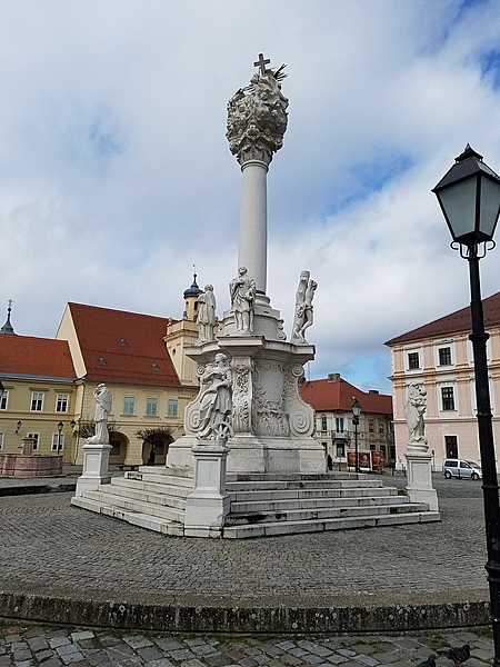
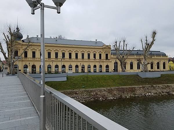
Osijek, the largest city and economic capital of eastern Croatia, lies on the the Drava River, 25 km upstream from the Danube. Its Old Town, referred to as Tvrda (Citadel), consists of a Habsburg-era fortress and has some of the best preserved baroque buildings in the country. The Holy Trinity column on the fort's main square dates to 1730 and was erected in thanksgiving for the lifting of a plague.
Osijek, the largest city and economic capital of eastern Croatia, lies on the the Drava River, 25 km upstream from the Danube. Its Old Town, referred to as Tvrda (Citadel), consists of a Habsburg-era fortress and has some of the best preserved baroque buildings in the country. The Holy Trinity column on the fort's main square dates to 1730 and was erected in thanksgiving for the lifting of a plague. • CIA World Factbook • 2020
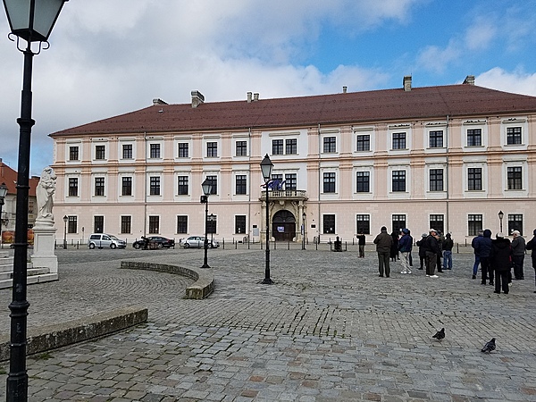
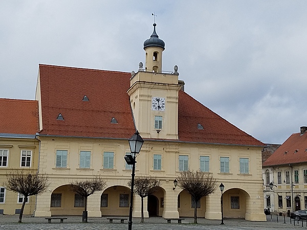
The Palace of the Slavonian General Command in Osijek is the former headquarters building for the Slavonian Military Frontier (part of the Habsburg Military Frontier guarding the border with Ottoman Empire). Constructed between 1724 and 1726, it is a synthesis of Renaissance and Baroque styles. Built on the orders of Prince Eugene of Savoy, it was the seat of the General Command between 1736 and 1786. From 1736 to 1745, it was also the administrative seat for the Kingdom of Slavonia. Today it serves as the office of the rector for the University of Osijek. Located on the northern side of the Holy Trinity square in Tvrđa, it is one of the symbols of Osijek and Croatia and is featured on the reverse of the Croatian 200-kuna banknote.
The Palace of the Slavonian General Command in Osijek is the former headquarters building for the Slavonian Military Frontier (part of the Habsburg Military Frontier guarding the border with Ottoman Empire). Constructed between 1724 and 1726, it is a synthesis of Renaissance and Baroque styles. Built on the orders of Prince Eugene of Savoy, it was the seat of the General Command between 1736 and 1786. From 1736 to 1745, it was also the administrative seat for the Kingdom of Slavonia. Today it serves as the office of the rector for the University of Osijek. Located on the northern side of the Holy Trinity square in Tvrđa, it is one of the symbols of Osijek and Croatia and is featured on the reverse of the Croatian 200-kuna banknote. • CIA World Factbook • 2020
Vukovar, on the confluence of the Vuka and Danube Rivers, is Croatia's largest river port. The city was almost completely destroyed during an 87-day siege by Yugoslav forces and Serbian militias from August to November 1991 after Croatia declared its independence from Yugoslavia. The city has been largely rebuilt but certain buildings remain unrepaired as reminders of the fighting that resulted in 2,000 defenders killed, several hundred soldiers and civilians massacred after the city fell, and at least 20,000 inhabitants expelled. The fighting for Vukovar has been described as the worst in Europe since World War II; the city's population today is only about 60% of its pre-war total.
Vukovar, on the confluence of the Vuka and Danube Rivers, is Croatia's largest river port. The city was almost completely destroyed during an 87-day siege by Yugoslav forces and Serbian militias from August to November 1991 after Croatia declared its independence from Yugoslavia. The city has been largely rebuilt but certain buildings remain unrepaired as reminders of the fighting that resulted in 2,000 defenders killed, several hundred soldiers and civilians massacred after the city fell, and at least 20,000 inhabitants expelled. The fighting for Vukovar has been described as the worst in Europe since World War II; the city's population today is only about 60% of its pre-war total. • CIA World Factbook • 2020
Osijek, the largest city and economic capital of eastern Croatia, lies on the the Drava River, 25 km upstream from the Danube. Its Old Town, referred to as Tvrda (Citadel), consists of a Habsburg-era fortress and has some of the best preserved baroque buildings in the country. The former Guardhouse, built in 1729, now hosts the Archaeological Museum.
Osijek, the largest city and economic capital of eastern Croatia, lies on the the Drava River, 25 km upstream from the Danube. Its Old Town, referred to as Tvrda (Citadel), consists of a Habsburg-era fortress and has some of the best preserved baroque buildings in the country. The former Guardhouse, built in 1729, now hosts the Archaeological Museum. • CIA World Factbook • 2020
Vukovar, on the confluence of the Vuka and Danube Rivers, is Croatia's largest river port. The city was almost completely destroyed during an 87-day siege by Yugoslav forces and Serbian militias from August to November 1991 after Croatia declared its independence from Yugoslavia. The city has been largely rebuilt but certain buildings remain unrepaired as reminders of the fighting that resulted in 2,000 defenders killed, several hundred soldiers and civilians massacred after the city fell, and at least 20,000 inhabitants expelled. The fighting for Vukovar has been described as the worst in Europe since World War II; the city's population today is only about 60% of its pre-war total.
Vukovar, on the confluence of the Vuka and Danube Rivers, is Croatia's largest river port. The city was almost completely destroyed during an 87-day siege by Yugoslav forces and Serbian militias from August to November 1991 after Croatia declared its independence from Yugoslavia. The city has been largely rebuilt but certain buildings remain unrepaired as reminders of the fighting that resulted in 2,000 defenders killed, several hundred soldiers and civilians massacred after the city fell, and at least 20,000 inhabitants expelled. The fighting for Vukovar has been described as the worst in Europe since World War II; the city's population today is only about 60% of its pre-war total. • CIA World Factbook • 2020
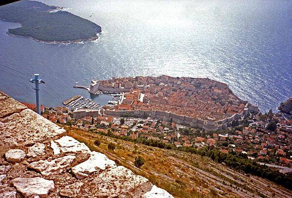
From a cliff overview, one can see the enormous walls and large harbor of old Dubrovnik.
From a cliff overview, one can see the enormous walls and large harbor of old Dubrovnik. • CIA World Factbook • 2020
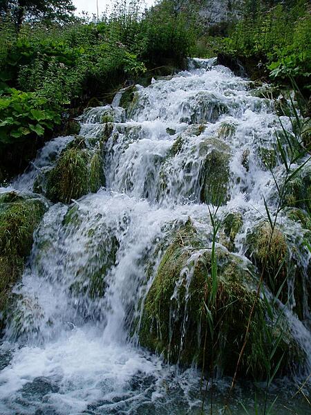
Close up of waterfalls in Plitvice Lakes National Park. The park is the largest and most popular of the eight national parks in Croatia and consists of 16 lakes linked but separated by natural dams.
Close up of waterfalls in Plitvice Lakes National Park. The park is the largest and most popular of the eight national parks in Croatia and consists of 16 lakes linked but separated by natural dams. • CIA World Factbook • 2020
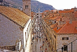
Stradun, the main street of Dubrovnik.
Stradun, the main street of Dubrovnik. • CIA World Factbook • 2020
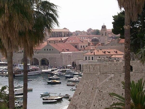
Dubrovnik harbor from outside of the city.
Dubrovnik harbor from outside of the city. • CIA World Factbook • 2020
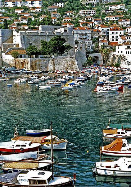
The inner harbor of Dubrovnik.
The inner harbor of Dubrovnik. • CIA World Factbook • 2020
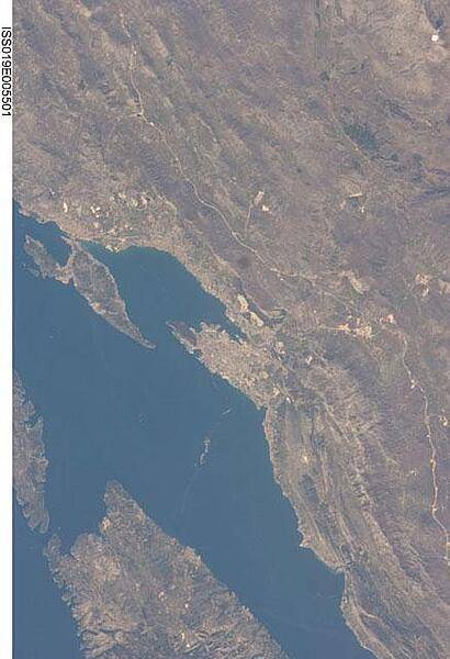
This view features the Dalmatian coastline of Croatia around the city of Split. Much of the region can be characterized by northwest-southeast oriented linear islands and embayments of the Adriatic Sea. This distinctive coastal geomorphology is the result of faulting caused by tectonic activity in the region and sea level rise. Photo courtesy of NASA.
This view features the Dalmatian coastline of Croatia around the city of Split. Much of the region can be characterized by northwest-southeast oriented linear islands and embayments of the Adriatic Sea. This distinctive coastal geomorphology is the result of faulting caused by tectonic activity in the region and sea level rise. Photo courtesy of NASA. • CIA World Factbook • 2020
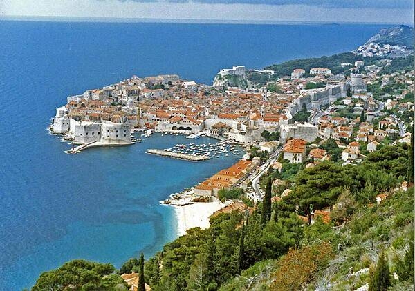
The beautiful port city of Dubrovnik on the Adriatic Sea. During the Middle Ages this maritime city-state (then called Ragusa) rivaled Venice for supremacy in the Adriatic. Walking along the crest of the massive walls that encircle most of Dubrovnik is an exhilarating, breathtaking experience. In 1979, the city became a UNESCO World Heritage Site.
The beautiful port city of Dubrovnik on the Adriatic Sea. During the Middle Ages this maritime city-state (then called Ragusa) rivaled Venice for supremacy in the Adriatic. Walking along the crest of the massive walls that encircle most of Dubrovnik is an exhilarating, breathtaking experience. In 1979, the city became a UNESCO World Heritage Site. • CIA World Factbook • 2020
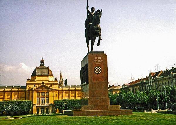
Statue of King Tomislav in his eponymous square in Zagreb. Tomislav reigned from 910 to 928, first as the Duke of Dalmatia and then as the first King of Croatia.
Statue of King Tomislav in his eponymous square in Zagreb. Tomislav reigned from 910 to 928, first as the Duke of Dalmatia and then as the first King of Croatia. • CIA World Factbook • 2020
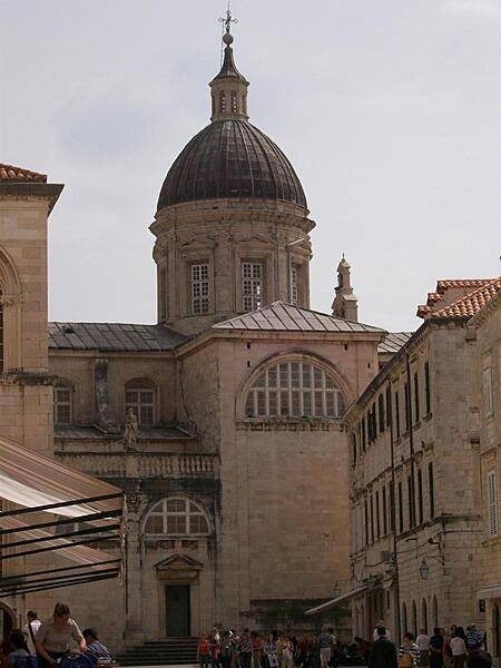
A cathedral within the city walls of Dubrovnik.
A cathedral within the city walls of Dubrovnik. • CIA World Factbook • 2020
Media source: CIA World Factbook (2020) — Public Domain