›››
Indonesia
Indonesia
Population
283.5M
Rank #4Source: World Bank
Capital
Jakarta
Source: REST Countries
Region
Asia
East Asia & Pacific
Source: REST Countries
GDP (Nominal)
$1.40T
Rank #16Source: World Bank
Land Area
1.9M km²
Rank #15Source: REST Countries
Life Expectancy
71.146 yrs
Source: World Bank
Historical Trends
Population Trend (5-Year)
Source: World Bank
GDP Trend (5-Year, Nominal USD)
Source: World Bank
Geography
Area: 1,904,569 km²
Landlocked: No
Independent: Yes
Climate: tropical; hot, humid; more moderate in highlands
Terrain: mostly coastal lowlands; larger islands have interior mountains
Elevation: mean elevation: 367 m lowest point: Indian Ocean 0 m highest point: Puncak Jaya 4,884 m
Natural Hazards: occasional floods; severe droughts; tsunamis; earthquakes; volcanoes; forest firesvolcanism: Indonesia contains the most volcanoes of any country in the world - some 76 are historically active;...
Environmental Issues: large-scale deforestation (much of it illegal) and related wildfires cause heavy smog; over-exploitation of marine resources; environmental problems associated with rapid urbanization and economic...
Land Use: agricultural land: 31.2% (2011 est.) forest: 51.7% (2011 est.) other: 17.1% (2011 est.)
Geography Note: note 1: according to Indonesia's National Coordinating Agency for Survey and Mapping, the total number of islands in the archipelago is 13,466, of which 922 are permanently inhabited (Indonesia is...
Natural Resources
petroleumtinnatural gasnickeltimberbauxitecopperfertile soilscoalgold
People & Society
Fertility Rate
2.13
Population
283.5M
Ethnic Groups
Javanese (40.1%)Sundanese (15.5%)Malay (3.7%)Batak (3.6%)Madurese (3%)Betawi (2.9%)Minangkabau (2.7%)Buginese (2.7%)Bantenese (2%)Banjarese (1.7%)Balinese (1.7%)Acehnese (1.4%)Dayak (1.4%)Sasak (1.3%)Chinese (1.2%)other (15%)
Religions
Muslim (87.2%)Protestant (7%)Roman Catholic (2.9%)Hindu (1.7%)other (0.9%)unspecified (0.4%)
Economy
GDP per Capita
$4,925.43
GDP per Capita PPP
16,448.276
(2024)
(2024)
GNI per Capita
4,910
(2024)
(2024)
Gini Index
34.9
(2024)
(2024)
Unemployment
3.301%
(2024)
(2024)
Inflation
2.182%
(2024)
(2024)
Public Debt
Not Available
Energy
Electricity Access
99.4%
(2023)
(2023)
Renewable Energy
20.2%
(2021)
(2021)
CO₂ Emissions
812.204 Mt
(2024)
(2024)
Energy Intensity
3.04 MJ/$
(2021)
(2021)
Renewable Electricity
15.53%
(2021)
(2021)
Environment
Forest Coverage
47.722% of land
(2023)
(2023)
Communications
Internet Users
72.781%
(2024)
(2024)
Mobile Penetration
125.238%
(2023)
(2023)
Broadband Subscribers
4.817%
(2023)
(2023)
Transportation
Air Transport Freight
870.513 M ton-km
(2023)
(2023)
Container Port Traffic
12,380,584 TEU
(2022)
(2022)
Airports
736,333.454
Rail Lines
5,483 km
Roads Total
543,720 km(©IRF)
Military
Military Forces
Indonesian National Armed Forces (Tentara Nasional Indonesia, TNI): Army (TNI-Angkatan Darat (TNI-AD)), Navy (TNI-Angkatan Laut (TNI-AL), includes marines (Korps Marinir, KorMar), naval air arm), Air...
Personnel Strength
the Indonesian National Armed Forces have an estimated 395,000 active duty troops (300,000 Army; 65,000 Navy; 30,000 Air Force); the Police Mobile Brigade Corps (BRIMOB) has an estimated 14,000...
Military Expenditure (USD)
$11.04B
Military Expenditure (% of GDP)
0.78%
Military Expenditure History
0.7% of GDP (2019) 0.7% of GDP (2018) 0.9% of GDP (2017) 0.8% of GDP (2016) 0.9% of GDP (2015)
Deployments
200 Central African Republic (MINUSCA); 1,025 Democratic Republic of the Congo (MONUSCO); 1,250 Lebanon (UNIFIL) (2020)
Equipment & Inventories
the Indonesian military inventory is comprised of equipment from a wide variety of sources; since 2010, the top suppliers are China, Germany, the Netherlands, Russia, South Korea, the UK, and the US...
Service Age & Obligation
18-45 years of age for voluntary military service, with selective conscription authorized; 2-year service obligation, with reserve obligation to age 45 (officers); Indonesian citizens only
Education
Pre-Primary Enrollment
62.344%
(2018)
(2018)
Primary Enrollment
100.036%
(2024)
(2024)
Secondary Enrollment
98.836%
(2024)
(2024)
Tertiary Enrollment
44.881%
(2023)
(2023)
Education Spending
1.275% of GDP
(2023)
(2023)
Adult Literacy Rate
96%
(2020)
(2020)
Pupil-Teacher Ratio
17.035:1
(2018)
(2018)
Health
Physicians per 1,000
0.524
(2023)
(2023)
Safe Water Access
89.009%
(2024)
(2024)
Safe Drinking Water
30.461%
(2024)
(2024)
Under-5 Mortality
20.6 per 1,000
(2023)
(2023)
Maternal Mortality (World Bank)
16.505 per 100,000
(2021)
(2021)
Hospital Beds per 1,000
68.262
(2021)
(2021)
UHC Coverage Index
67
(2023)
(2023)
Measles Immunization
78%
(2024)
(2024)
Social Indicators
Extreme Poverty Rate
5.4%
(2024)
(2024)
Food Insecurity
6.3%
(2023)
(2023)
Youth NEET Rate
13.119%
(2023)
(2023)
Governance
Women in Government
21.034%
(2024)
(2024)
Voice & Accountability
0.14
(Above Average)
(2023)
(Above Average)
(2023)
Political Stability
-0.40
(Below Average)
(2023)
(Below Average)
(2023)
Government Effectiveness
0.58
(Above Average)
(2023)
(Above Average)
(2023)
Regulatory Quality
0.30
(Above Average)
(2023)
(Above Average)
(2023)
Rule of Law
-0.15
(Below Average)
(2023)
(Below Average)
(2023)
Control of Corruption
-0.49
(Below Average)
(2023)
(Below Average)
(2023)
Government
Government Type
presidential republic
Legal System
civil law system based on the Roman-Dutch model and influenced by customary law
Executive Branch
chief of state: President Joko WIDODO (since 20 October 2014, reelected 17 April 2019, inauguration 19 October 2019); Vice President Ma'ruf AMIN (since 20 October 2019); note - the president is both...
Legislative Branch
description: bicameral People's Consultative Assembly or Majelis Permusyawaratan Rakyat consists of:Regional Representative Council or Dewan Perwakilan Daerah (136 seats; non-partisan members...
Judicial Branch
highest courts: Supreme Court or Mahkamah Agung (51 judges divided into 8 chambers); Constitutional Court or Mahkamah Konstitusi (consists of 9 judges) judge selection and term of office: Supreme...
National Symbols
Flag Description
two equal horizontal bands of red (top) and white; the colors derive from the banner of the Majapahit Empire of the 13th-15th centuries; red symbolizes courage, white represents puritynote: similar...
National Symbols
garuda (mythical bird); national colors: red, white
National Anthem
name: "Indonesia Raya" (Great Indonesia) lyrics/music: Wage Rudolf SOEPRATMAN note: adopted 1945
Safety
Homicide Rate
0.304 per 100,000
(2022)
(2022)
Travel Information
Language(s): Indonesian
Currency: IDR (Rp)
Timezone(s): UTC +07:00 to +09:00
Landlocked: No
Independent: Yes
Driving Side: Left
Calling Code: +62
Car Sign: RI
Week Starts: Monday
Photos
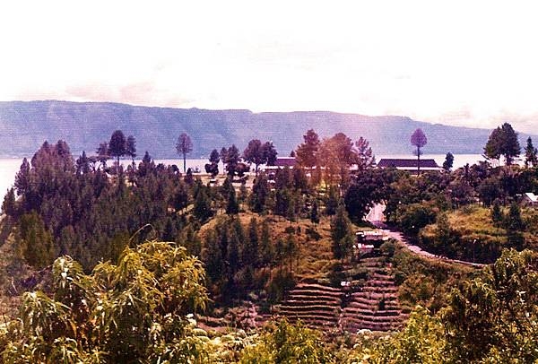
Lake Toba is located in the middle of the northern part of the island of Sumatra, occupying the caldera of a supervolcano. The lake is about 100 km (62 mi) long, 30 km (19 mi) wide, and up to 505 m (1,657 ft) deep. It is the largest lake in Indonesia and the largest volcanic lake in the world. Lake Toba is the site of a supervolcanic eruption estimated at a Volcanic Explosivity Index (VEI) of 8, the largest recorded value on the index. Recent advances in dating methods suggest the date was 74,000 years ago and that it represented a climate-changing event. It is the largest-known explosive eruption on earth in the last 25 million years.
Lake Toba is located in the middle of the northern part of the island of Sumatra, occupying the caldera of a supervolcano. The lake is about 100 km (62 mi) long, 30 km (19 mi) wide, and up to 505 m (1,657 ft) deep. It is the largest lake in Indonesia and the largest volcanic lake in the world.
Lake Toba is the site of a supervolcanic eruption estimated at a Volcanic Explosivity Index (VEI) of 8, the largest recorded value on the index. Recent advances in dating methods suggest the date was 74,000 years ago and that it represented a climate-changing event. It is the largest-known explosive eruption on earth in the last 25 million years. • CIA World Factbook • 2020
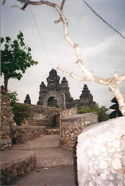
The Sea Temple of Pura Luhur at Uluwatu in south Bali dates back to the 11th century.
The Sea Temple of Pura Luhur at Uluwatu in south Bali dates back to the 11th century. • CIA World Factbook • 2020
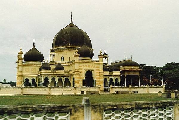
A mosque in Medan, the capital and largest city of the Indonesian province of North Sumatra.
A mosque in Medan, the capital and largest city of the Indonesian province of North Sumatra. • CIA World Factbook • 2020
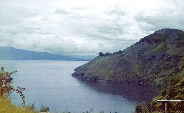
Lake Toba is located in the middle of the northern part of the island of Sumatra, occupying the caldera of a supervolcano. The lake is about 100 km (62 mi) long, 30 km (19 mi) wide, and up to 505 m (1,657 ft) deep. It is the largest lake in Indonesia and the largest volcanic lake in the world. Lake Toba is the site of a supervolcanic eruption estimated at a Volcanic Explosivity Index (VEI) of 8, the largest recorded value on the index. Recent advances in dating methods suggest the date was 74,000 years ago and that it represented a climate-changing event. It is the largest-known explosive eruption on earth in the last 25 million years.
Lake Toba is located in the middle of the northern part of the island of Sumatra, occupying the caldera of a supervolcano. The lake is about 100 km (62 mi) long, 30 km (19 mi) wide, and up to 505 m (1,657 ft) deep. It is the largest lake in Indonesia and the largest volcanic lake in the world.
Lake Toba is the site of a supervolcanic eruption estimated at a Volcanic Explosivity Index (VEI) of 8, the largest recorded value on the index. Recent advances in dating methods suggest the date was 74,000 years ago and that it represented a climate-changing event. It is the largest-known explosive eruption on earth in the last 25 million years. • CIA World Factbook • 2020
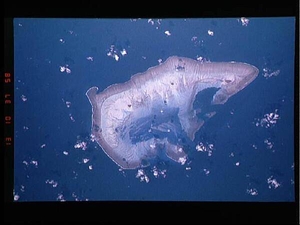
Ashmore Island (actually composed of three reef islets) is part of Ashmore Reef National Nature Reserve, established in August 1983, and covers 583 sq km (225 sq mi). It is of significant biodiversity value since it lies in the flow of the Indonesian Throughflow ocean current from the Pacific Ocean through the Malay archipelago to the Indian Ocean. It is also in a surface current west from the Arafura Sea and Timor Sea. The Reserve comprises several marine habitats, including seagrass meadows, intertidal sand flats, coral reef flats, and lagoons, and supports an important and diverse range of species, including 14 species of sea snakes, a population of dugong that may be genetically distinct, a diverse marine invertebrate fauna, and many endemic species, especially of sea snakes and molluscs. There are feeding and nesting sites for various turtle species. It also serves as a bird sanctuary and has 50,000 breeding pairs of various kinds of seabirds. A high abundance and diversity of sea cucumbers, over-exploited on other reefs in the region, is present, with 45 species recorded. This astronaut photo from 1992 shows that the reef making up the island is not continuous but has several breaks that allow for current and sediment inflow. Image courtesy of NASA.
Ashmore Island (actually composed of three reef islets) is part of Ashmore Reef National Nature Reserve, established in August 1983, and covers 583 sq km (225 sq mi). It is of significant biodiversity value since it lies in the flow of the Indonesian Throughflow ocean current from the Pacific Ocean through the Malay archipelago to the Indian Ocean. It is also in a surface current west from the Arafura Sea and Timor Sea.
The Reserve comprises several marine habitats, including seagrass meadows, intertidal sand flats, coral reef flats, and lagoons, and supports an important and diverse range of species, including 14 species of sea snakes, a population of dugong that may be genetically distinct, a diverse marine invertebrate fauna, and many endemic species, especially of sea snakes and molluscs. There are feeding and nesting sites for various turtle species. It also serves as a bird sanctuary and has 50,000 breeding pairs of various kinds of seabirds. A high abundance and diversity of sea cucumbers, over-exploited on other reefs in the region, is present, with 45 species recorded.
This astronaut photo from 1992 shows that the reef making up the island is not continuous but has several breaks that allow for current and sediment inflow. Image courtesy of NASA. • CIA World Factbook • 2020
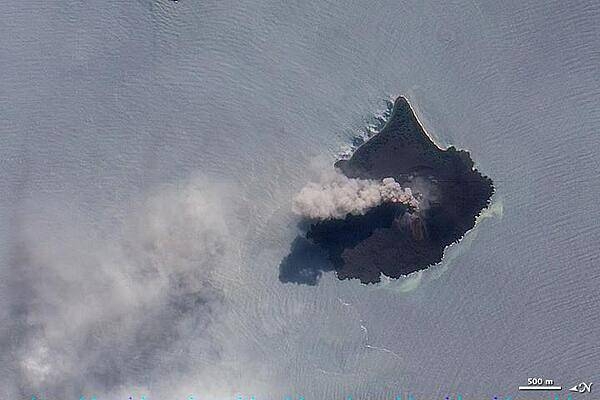
The thick brown plume of ash, steam, and volcanic gas rising from Anak Krakatau in this true-color image is a common sight at the volcano. Responsible for one of the largest and most destructive eruptions in Indonesia's history (1883), Krakatau still erupts frequently. For this reason, the volcano is one of 100 that NASA automatically monitors by satellite. Photo courtesy of NASA.
The thick brown plume of ash, steam, and volcanic gas rising from Anak Krakatau in this true-color image is a common sight at the volcano. Responsible for one of the largest and most destructive eruptions in Indonesia's history (1883), Krakatau still erupts frequently. For this reason, the volcano is one of 100 that NASA automatically monitors by satellite. Photo courtesy of NASA. • CIA World Factbook • 2020
17 photos available
View All Photos→Data sources: World Bank, UN Data • Updated daily •Learn about our data