›››
Indonesia — Media Gallery
17 items available (flags, maps, photos)
Photos
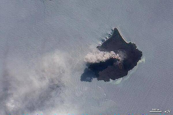
The thick brown plume of ash, steam, and volcanic gas rising from Anak Krakatau in this true-color image is a common sight at the volcano. Responsible for one of the largest and most destructive eruptions in Indonesia's history (1883), Krakatau still erupts frequently. For this reason, the volcano is one of 100 that NASA automatically monitors by satellite. Photo courtesy of NASA.
The thick brown plume of ash, steam, and volcanic gas rising from Anak Krakatau in this true-color image is a common sight at the volcano. Responsible for one of the largest and most destructive eruptions in Indonesia's history (1883), Krakatau still erupts frequently. For this reason, the volcano is one of 100 that NASA automatically monitors by satellite. Photo courtesy of NASA. • CIA World Factbook • 2020
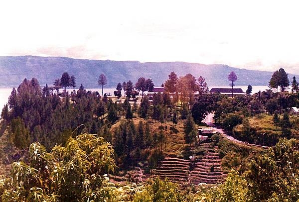
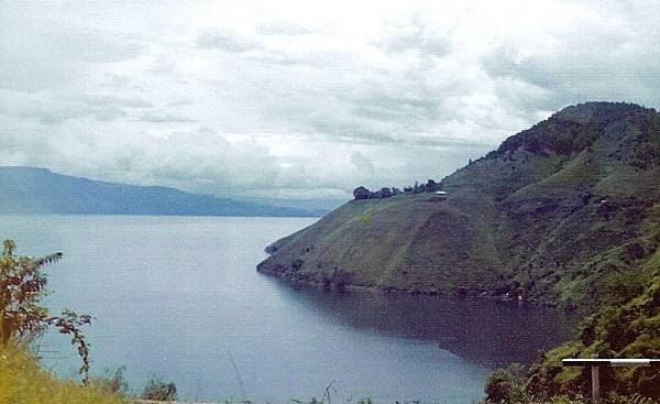
Lake Toba is located in the middle of the northern part of the island of Sumatra, occupying the caldera of a supervolcano. The lake is about 100 km (62 mi) long, 30 km (19 mi) wide, and up to 505 m (1,657 ft) deep. It is the largest lake in Indonesia and the largest volcanic lake in the world. Lake Toba is the site of a supervolcanic eruption estimated at a Volcanic Explosivity Index (VEI) of 8, the largest recorded value on the index. Recent advances in dating methods suggest the date was 74,000 years ago and that it represented a climate-changing event. It is the largest-known explosive eruption on earth in the last 25 million years.
Lake Toba is located in the middle of the northern part of the island of Sumatra, occupying the caldera of a supervolcano. The lake is about 100 km (62 mi) long, 30 km (19 mi) wide, and up to 505 m (1,657 ft) deep. It is the largest lake in Indonesia and the largest volcanic lake in the world.
Lake Toba is the site of a supervolcanic eruption estimated at a Volcanic Explosivity Index (VEI) of 8, the largest recorded value on the index. Recent advances in dating methods suggest the date was 74,000 years ago and that it represented a climate-changing event. It is the largest-known explosive eruption on earth in the last 25 million years. • CIA World Factbook • 2020
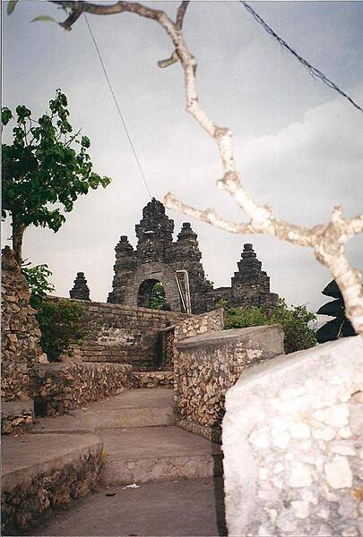
The Sea Temple of Pura Luhur at Uluwatu in south Bali dates back to the 11th century.
The Sea Temple of Pura Luhur at Uluwatu in south Bali dates back to the 11th century. • CIA World Factbook • 2020
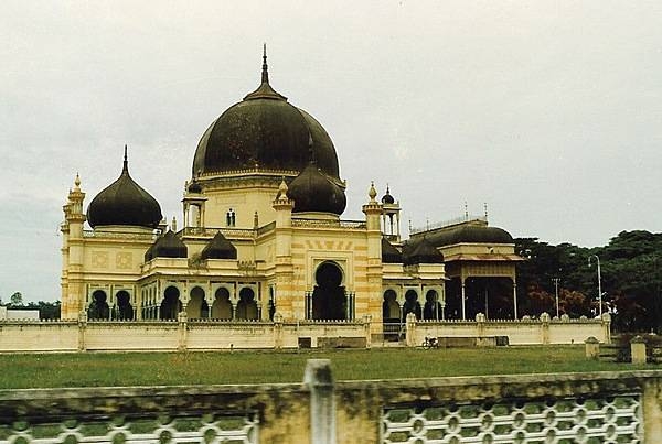
A mosque in Medan, the capital and largest city of the Indonesian province of North Sumatra.
A mosque in Medan, the capital and largest city of the Indonesian province of North Sumatra. • CIA World Factbook • 2020
Lake Toba is located in the middle of the northern part of the island of Sumatra, occupying the caldera of a supervolcano. The lake is about 100 km (62 mi) long, 30 km (19 mi) wide, and up to 505 m (1,657 ft) deep. It is the largest lake in Indonesia and the largest volcanic lake in the world. Lake Toba is the site of a supervolcanic eruption estimated at a Volcanic Explosivity Index (VEI) of 8, the largest recorded value on the index. Recent advances in dating methods suggest the date was 74,000 years ago and that it represented a climate-changing event. It is the largest-known explosive eruption on earth in the last 25 million years.
Lake Toba is located in the middle of the northern part of the island of Sumatra, occupying the caldera of a supervolcano. The lake is about 100 km (62 mi) long, 30 km (19 mi) wide, and up to 505 m (1,657 ft) deep. It is the largest lake in Indonesia and the largest volcanic lake in the world.
Lake Toba is the site of a supervolcanic eruption estimated at a Volcanic Explosivity Index (VEI) of 8, the largest recorded value on the index. Recent advances in dating methods suggest the date was 74,000 years ago and that it represented a climate-changing event. It is the largest-known explosive eruption on earth in the last 25 million years. • CIA World Factbook • 2020
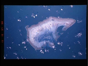
Ashmore Island (actually composed of three reef islets) is part of Ashmore Reef National Nature Reserve, established in August 1983, and covers 583 sq km (225 sq mi). It is of significant biodiversity value since it lies in the flow of the Indonesian Throughflow ocean current from the Pacific Ocean through the Malay archipelago to the Indian Ocean. It is also in a surface current west from the Arafura Sea and Timor Sea. The Reserve comprises several marine habitats, including seagrass meadows, intertidal sand flats, coral reef flats, and lagoons, and supports an important and diverse range of species, including 14 species of sea snakes, a population of dugong that may be genetically distinct, a diverse marine invertebrate fauna, and many endemic species, especially of sea snakes and molluscs. There are feeding and nesting sites for various turtle species. It also serves as a bird sanctuary and has 50,000 breeding pairs of various kinds of seabirds. A high abundance and diversity of sea cucumbers, over-exploited on other reefs in the region, is present, with 45 species recorded. This astronaut photo from 1992 shows that the reef making up the island is not continuous but has several breaks that allow for current and sediment inflow. Image courtesy of NASA.
Ashmore Island (actually composed of three reef islets) is part of Ashmore Reef National Nature Reserve, established in August 1983, and covers 583 sq km (225 sq mi). It is of significant biodiversity value since it lies in the flow of the Indonesian Throughflow ocean current from the Pacific Ocean through the Malay archipelago to the Indian Ocean. It is also in a surface current west from the Arafura Sea and Timor Sea.
The Reserve comprises several marine habitats, including seagrass meadows, intertidal sand flats, coral reef flats, and lagoons, and supports an important and diverse range of species, including 14 species of sea snakes, a population of dugong that may be genetically distinct, a diverse marine invertebrate fauna, and many endemic species, especially of sea snakes and molluscs. There are feeding and nesting sites for various turtle species. It also serves as a bird sanctuary and has 50,000 breeding pairs of various kinds of seabirds. A high abundance and diversity of sea cucumbers, over-exploited on other reefs in the region, is present, with 45 species recorded.
This astronaut photo from 1992 shows that the reef making up the island is not continuous but has several breaks that allow for current and sediment inflow. Image courtesy of NASA. • CIA World Factbook • 2020
Kuta Beach, Bali.
Kuta Beach, Bali. • CIA World Factbook • 2020
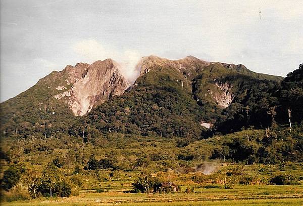
Inside the caldera of a dormant volcano on the island of Sumatra.
Inside the caldera of a dormant volcano on the island of Sumatra. • CIA World Factbook • 2020
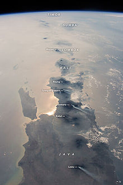
This photograph, taken from the International Space Station in 2015, looks eastward: Java is in the foreground, Bali and Lombok are near the center, and smaller islands trail off toward the horizon. The brightest reflection of the Sun off the sea surface silhouettes Surabaya, Indonesia’s second-largest city of almost 3 million. Against this background of glint as well as regional smoke, a line of volcanoes appears in sharp detail. Volcanoes are the backbone of the islands, which have been formed by the collision of the Australian tectonic plate (right) with the Asian plate (left). The name of each volcano appears in italics. White plumes - each about 80 km (50 mi) long - show that at least six volcanoes appeared to be emitting steam and smoke. The plumes are strikingly parallel, aligned with winds from the northeast. Image courtesy of NASA.
This photograph, taken from the International Space Station in 2015, looks eastward: Java is in the foreground, Bali and Lombok are near the center, and smaller islands trail off toward the horizon. The brightest reflection of the Sun off the sea surface silhouettes Surabaya, Indonesia’s second-largest city of almost 3 million. Against this background of glint as well as regional smoke, a line of volcanoes appears in sharp detail. Volcanoes are the backbone of the islands, which have been formed by the collision of the Australian tectonic plate (right) with the Asian plate (left). The name of each volcano appears in italics. White plumes - each about 80 km (50 mi) long - show that at least six volcanoes appeared to be emitting steam and smoke. The plumes are strikingly parallel, aligned with winds from the northeast. Image courtesy of NASA. • CIA World Factbook • 2020
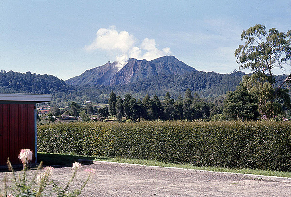
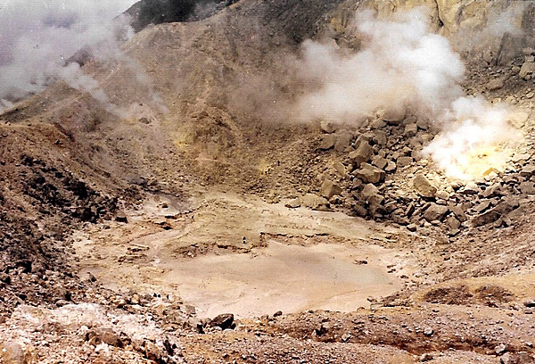
Indonesia is tectonically highly unstable, making it the site of numerous volcanoes and frequent earthquakes. The archipelago lies on the Pacific Ring of Fire where the Indo-Australian Plate and the Pacific Plate are pushed under the Eurasian plate and where they melt at about 100 km (62 mi) below the earths' surface. A string of volcanoes runs southeastward through Sumatra, Java, Bali, and Nusa Tenggara, and then fishhooks north and westward to the Banda Islands of Maluku and North Sulawesi. Indonesia has about 150 active volcanoes, the most of any country on earth. The photo shows a dormant but smoking volcano on the island of Sumatra.
Indonesia is tectonically highly unstable, making it the site of numerous volcanoes and frequent earthquakes. The archipelago lies on the Pacific Ring of Fire where the Indo-Australian Plate and the Pacific Plate are pushed under the Eurasian plate and where they melt at about 100 km (62 mi) below the earths' surface. A string of volcanoes runs southeastward through Sumatra, Java, Bali, and Nusa Tenggara, and then fishhooks north and westward to the Banda Islands of Maluku and North Sulawesi. Indonesia has about 150 active volcanoes, the most of any country on earth. The photo shows a dormant but smoking volcano on the island of Sumatra. • CIA World Factbook • 2020
Evidence of tectonic activity. A dormant but smoking volcano on the island of Sumatra.
Evidence of tectonic activity. A dormant but smoking volcano on the island of Sumatra. • CIA World Factbook • 2020
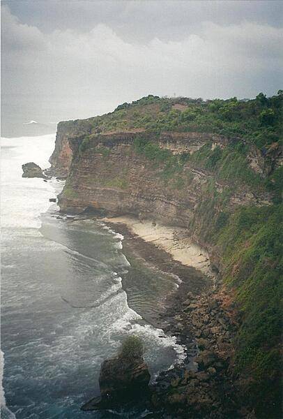
View from the cliffs at Pura Luhur Uluwatu, Bali.
View from the cliffs at Pura Luhur Uluwatu, Bali. • CIA World Factbook • 2020
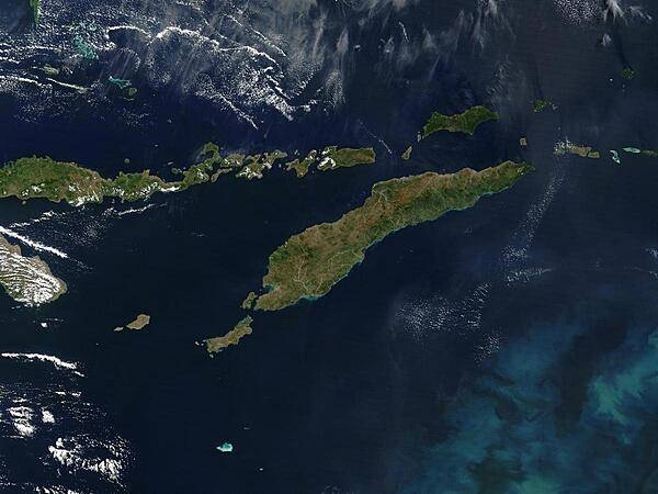
Southeast of the island of Timor (center), a phytoplankton bloom is coloring the waters of the Timor Sea, which separates Timor from northwestern Australia. To the north of Timor is Flores, which is home to numerous active volcanoes. (The red dots are due to fire, not volcanic activity.) The eastern half of Timor, as well as an exclave to the west and a few offshore islands, constitute the country of Timor-Leste. The western portion of Timor and the remaining islands (including Flores) belong to Indonesia. Image courtesy of NASA.
Southeast of the island of Timor (center), a phytoplankton bloom is coloring the waters of the Timor Sea, which separates Timor from northwestern Australia. To the north of Timor is Flores, which is home to numerous active volcanoes. (The red dots are due to fire, not volcanic activity.) The eastern half of Timor, as well as an exclave to the west and a few offshore islands, constitute the country of Timor-Leste. The western portion of Timor and the remaining islands (including Flores) belong to Indonesia. Image courtesy of NASA. • CIA World Factbook • 2020
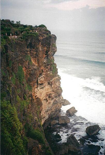
The Sea Temple of Pura Luhur at Uluwatu in south Bali perches on some very impressive cliffs.
The Sea Temple of Pura Luhur at Uluwatu in south Bali perches on some very impressive cliffs. • CIA World Factbook • 2020
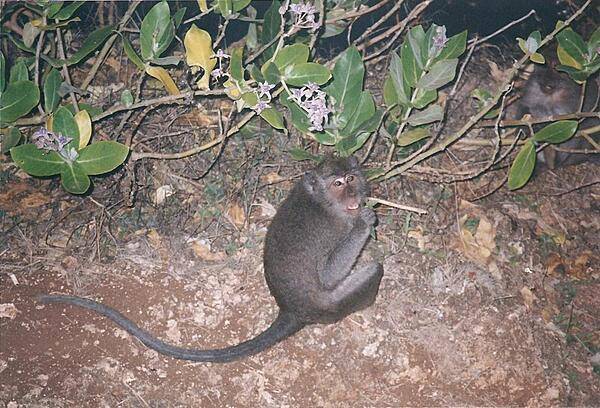
The monkeys at Pura Luhur Uluwatu on Bali are notorious pickpockets.
The monkeys at Pura Luhur Uluwatu on Bali are notorious pickpockets. • CIA World Factbook • 2020
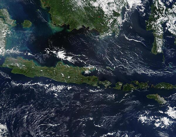
This true-color image of some of the Indonesian islands is from mid-May 2002. Fire season was not fully underway in the region, and skies over the large island of Borneo (top) were partially cloud-covered, but not hazy with air pollution. The horizontally situated island of Java appears to be experiencing some haze at its western end, and a few scattered fires (red dots) are apparent. Image courtesy of NASA.
This true-color image of some of the Indonesian islands is from mid-May 2002. Fire season was not fully underway in the region, and skies over the large island of Borneo (top) were partially cloud-covered, but not hazy with air pollution. The horizontally situated island of Java appears to be experiencing some haze at its western end, and a few scattered fires (red dots) are apparent. Image courtesy of NASA. • CIA World Factbook • 2020
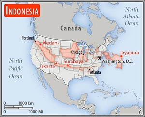
Area comparison map
Area comparison map • CIA World Factbook • 2020
Media source: CIA World Factbook (2020) — Public Domain