›››
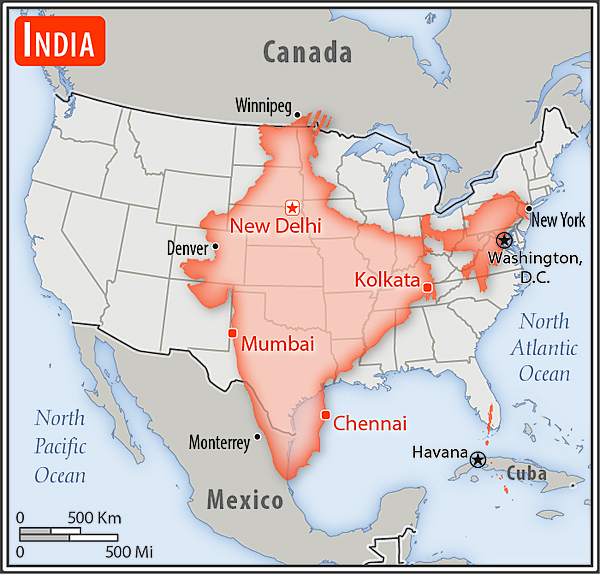
India
India
Population
1.5B
Rank #1Source: World Bank
Capital
New Delhi
Source: REST Countries
Region
Asia
South Asia
Source: REST Countries
GDP (Nominal)
$3.91T
Rank #5Source: World Bank
Land Area
3.3M km²
Rank #7Source: REST Countries
Life Expectancy
72.003 yrs
Source: World Bank
Historical Trends
Population Trend (5-Year)
Source: World Bank
GDP Trend (5-Year, Nominal USD)
Source: World Bank
Geography
Area: 3,287,263 km²
Landlocked: No
Independent: Yes
Climate: varies from tropical monsoon in south to temperate in north
Terrain: upland plain (Deccan Plateau) in south, flat to rolling plain along the Ganges, deserts in west, Himalayas in north
Elevation: mean elevation: 160 m lowest point: Indian Ocean 0 m highest point: Kanchenjunga 8,586 m
Natural Hazards: droughts; flash floods, as well as widespread and destructive flooding from monsoonal rains; severe thunderstorms; earthquakesvolcanism: Barren Island (354 m) in the Andaman Sea has been active in...
Environmental Issues: deforestation; soil erosion; overgrazing; desertification; air pollution from industrial effluents and vehicle emissions; water pollution from raw sewage and runoff of agricultural pesticides; tap...
Land Use: agricultural land: 60.5% (2011 est.) forest: 23.1% (2011 est.) other: 16.4% (2011 est.)
Geography Note: dominates South Asian subcontinent; near important Indian Ocean trade routes; Kanchenjunga, third tallest mountain in the world, lies on the border with Nepal
Natural Resources
coal (fourth-largest reserves in the world)antimonyiron oreleadmanganesemicabauxiterare earth elementstitanium orechromite
People & Society
Fertility Rate
1.98
Population
1.5B
Ethnic Groups
Indo-Aryan (72%)Dravidian (25%)Mongoloid and other (3%)
Religions
Hindu (79.8%)Muslim (14.2%)Christian (2.3%)Sikh (1.7%)other and unspecified (2%)
Economy
GDP per Capita
$2,694.738
GDP per Capita PPP
11,159.986
(2024)
(2024)
GNI per Capita
2,650
(2024)
(2024)
Gini Index
25.5
(2022)
(2022)
Unemployment
4.173%
(2024)
(2024)
Inflation
4.953%
(2024)
(2024)
Public Debt
46.522%
(2018)
(2018)
Energy
Electricity Access
99.5%
(2023)
(2023)
Renewable Energy
34.9%
(2021)
(2021)
CO₂ Emissions
3,153.829 Mt
(2024)
(2024)
Energy Intensity
4.21 MJ/$
(2021)
(2021)
Renewable Electricity
19.131%
(2021)
(2021)
Environment
Forest Coverage
24.539% of land
(2023)
(2023)
Communications
Internet Users
55.9%
(2022)
(2022)
Mobile Penetration
80.563%
(2023)
(2023)
Broadband Subscribers
2.745%
(2023)
(2023)
Transportation
Air Transport Freight
1,806.986 M ton-km
(2023)
(2023)
Container Port Traffic
19,717,168 TEU
(2022)
(2022)
Airports
1,234,696
Rail Lines
68,102.73 km
Roads Total
6,360,004 km(©IRF)
Military
Military Forces
Indian Armed Forces: Army, Navy (includes marines), Air Force, Coast Guard; Defense Security Corps (paramilitary forces); Ministry of Home Affairs paramilitary forces: Central Armed Police Force...
Personnel Strength
assessments of the size of the Indian Armed Forces vary; approximately 1.45 million active personnel (est. 1.25 million Army; 66,000 Navy; 140,000 Air Force; 11,000 Coast Guard); est. 1.5 million...
Military Expenditure (USD)
$86.13B
Military Expenditure (% of GDP)
2.27%
Military Expenditure History
2.4% of GDP (2019) 2.4% of GDP (2018) 2.5% of GDP (2017) 2.5% of GDP (2016) 2.4% of GDP (2015)
Deployments
1,900 Democratic Republic of the Congo (MONUSCO); 190 Golan Heights (UNDOF); 780 Lebanon (UNIFIL); 2,350 South Sudan (UNMISS) (2020)
Equipment & Inventories
the inventory of the Indian Armed Forces consists mostly of Russian-origin equipment, along with a smaller mix of Western and domestically-produced arms; since 2010, Russia is the leading supplier of...
Service Age & Obligation
16-18 years of age for voluntary military service (Army 17 1/2, Air Force 17, Navy 16 1/2); no conscription; women may join as officers, currently serve in combat roles as pilots, and under...
Education
Pre-Primary Enrollment
51.687%
(2021)
(2021)
Primary Enrollment
120.52%
(2024)
(2024)
Secondary Enrollment
78.106%
(2024)
(2024)
Tertiary Enrollment
34.418%
(2024)
(2024)
Education Spending
4.099% of GDP
(2022)
(2022)
Adult Literacy Rate
81.7%
(2023)
(2023)
Pupil-Teacher Ratio
32.75:1
(2017)
(2017)
Health
Physicians per 1,000
0.723
(2020)
(2020)
Safe Water Access
95.725%
(2024)
(2024)
Safe Drinking Water
76.442%
(2024)
(2024)
Under-5 Mortality
27.7 per 1,000
(2023)
(2023)
Maternal Mortality (World Bank)
16.512 per 100,000
(2021)
(2021)
Hospital Beds per 1,000
69.02
(2021)
(2021)
UHC Coverage Index
69
(2023)
(2023)
Measles Immunization
94%
(2024)
(2024)
Social Indicators
Extreme Poverty Rate
5.3%
(2022)
(2022)
Food Insecurity
12%
(2023)
(2023)
Youth NEET Rate
15.562%
(2024)
(2024)
Governance
Women in Government
13.653%
(2024)
(2024)
Voice & Accountability
0.09
(Above Average)
(2023)
(Above Average)
(2023)
Political Stability
-0.64
(Below Average)
(2023)
(Below Average)
(2023)
Government Effectiveness
0.47
(Above Average)
(2023)
(Above Average)
(2023)
Regulatory Quality
-0.14
(Below Average)
(2023)
(Below Average)
(2023)
Rule of Law
0.19
(Above Average)
(2023)
(Above Average)
(2023)
Control of Corruption
-0.37
(Below Average)
(2023)
(Below Average)
(2023)
Government
Government Type
federal parliamentary republic
Legal System
common law system based on the English model; separate personal law codes apply to Muslims, Christians, and Hindus; judicial review of legislative acts; note - in late 2019 the Government of India...
Executive Branch
chief of state: President Ram Nath KOVIND (since 25 July 2017); Vice President M. Venkaiah NAIDU (since 11 August 2017) head of government: Prime Minister Narendra MODI (since 26 May...
Legislative Branch
description: bicameral Parliament or Sansad consists of:Council of States or Rajya Sabha (245 seats; 233 members indirectly elected by state and territorial assemblies by proportional representation...
Judicial Branch
highest courts: Supreme Court (consists of 28 judges, including the chief justice) judge selection and term of office: justices appointed by the president to serve until age 65 subordinate...
International Organizations
National Symbols
Flag Description
three equal horizontal bands of saffron (subdued orange) (top), white, and green, with a blue chakra (24-spoked wheel) centered in the white band; saffron represents courage, sacrifice, and the...
National Symbols
the Lion Capital of Ashoka, which depicts four Asiatic lions standing back to back mounted on a circular abacus, is the official emblem; Bengal tiger; lotus flower; national colors: saffron, white,...
National Anthem
name: "Jana-Gana-Mana" (Thou Art the Ruler of the Minds of All People) lyrics/music: Rabindranath TAGORE note: adopted 1950; Rabindranath TAGORE, a Nobel laureate, also wrote Bangladesh's national...
Safety
Homicide Rate
2.815 per 100,000
(2022)
(2022)
Travel Information
Language(s): English, Hindi, Tamil
Currency: INR (₹)
Timezone(s): UTC+05:30
Landlocked: No
Independent: Yes
Driving Side: Left
Calling Code: +91
Car Sign: IND
Week Starts: Monday
Photos
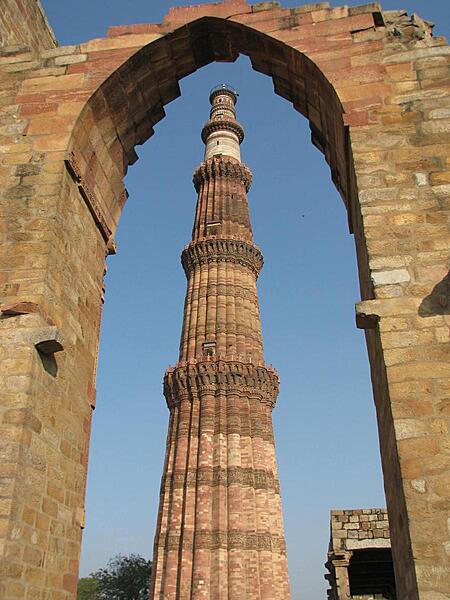
Qutab Minar, a tower in Delhi, is the world's tallest free standing brick and stone minaret. The structure is 72.5 m (238 ft) high with 379 steps leading to the top.
Qutab Minar, a tower in Delhi, is the world's tallest free standing brick and stone minaret. The structure is 72.5 m (238 ft) high with 379 steps leading to the top. • CIA World Factbook • 2020
This mound-like structure called the Dhamek Stupa is 143 feet high and 92 feet wide. Located in Sarnath, in the state of Uttar Pradesh, it is believed to be the location of Buddha's first sermon to his five disciples after attaining enlightenment.
This mound-like structure called the Dhamek Stupa is 143 feet high and 92 feet wide. Located in Sarnath, in the state of Uttar Pradesh, it is believed to be the location of Buddha's first sermon to his five disciples after attaining enlightenment. • CIA World Factbook • 2020
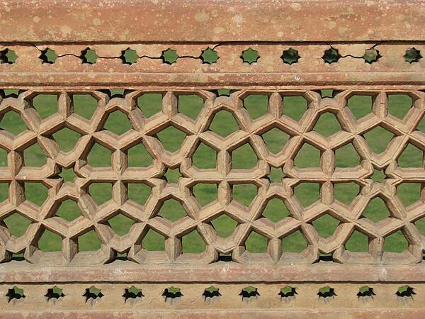
Complex carvings on the grounds of Humayun's Tomb.
Complex carvings on the grounds of Humayun's Tomb. • CIA World Factbook • 2020
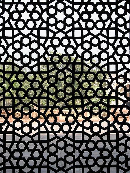
Elaborate latticework on the grounds of Humayun's Tomb.
Elaborate latticework on the grounds of Humayun's Tomb. • CIA World Factbook • 2020
Area comparison map
Area comparison map • CIA World Factbook • 2020
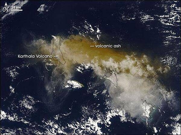
On 24 November 2005, some 2,000 people fled their homes hoping to escape the latest eruption of the Karthala Volcano. The volcano covered nearby villages in ash and locals had little means of protecting their lungs beyond covering their faces with scarves. Karthala is one of two volcanoes that make up Grande Comore (or N'gazidja) Island in the Comoros archipelago. These islands lie in the Indian Ocean, between Africa and Madagascar. In this image of 25 November 2005, Grande Comore appears only in outline as material from the eruption completely obscures the satellite's view of the land surface. The volcanic ash ranges in color from tan to beige; it has spread out around the volcano in all directions, but moves primarily eastward. With an altitude of 2,361 m (7,746 ft), Karthala is a shield volcano, with smooth slopes built from hardened lava. Comprising the southern portion of Grande Comore Island, Karthala is a regular troublemaker in its neighborhood. The volcano has erupted about 20 times in the last century. Photo courtesy of NASA.
On 24 November 2005, some 2,000 people fled their homes hoping to escape the latest eruption of the Karthala Volcano. The volcano covered nearby villages in ash and locals had little means of protecting their lungs beyond covering their faces with scarves.
Karthala is one of two volcanoes that make up Grande Comore (or N'gazidja) Island in the Comoros archipelago. These islands lie in the Indian Ocean, between Africa and Madagascar. In this image of 25 November 2005, Grande Comore appears only in outline as material from the eruption completely obscures the satellite's view of the land surface. The volcanic ash ranges in color from tan to beige; it has spread out around the volcano in all directions, but moves primarily eastward.
With an altitude of 2,361 m (7,746 ft), Karthala is a shield volcano, with smooth slopes built from hardened lava. Comprising the southern portion of Grande Comore Island, Karthala is a regular troublemaker in its neighborhood. The volcano has erupted about 20 times in the last century. Photo courtesy of NASA. • CIA World Factbook • 2020
55 photos available
View All Photos→Data sources: World Bank, UN Data • Updated daily •Learn about our data