›››
Korea, Rep.
Korea, Rep.
Population
51.8M
Rank #29Source: World Bank
Capital
Seoul
Source: REST Countries
Region
Asia
East Asia & Pacific
Source: REST Countries
GDP (Nominal)
$1.88T
Rank #12Source: World Bank
Land Area
100.2K km²
Rank #108Source: REST Countries
Life Expectancy
83.429 yrs
Source: World Bank
Historical Trends
Population Trend (5-Year)
Source: World Bank
GDP Trend (5-Year, Nominal USD)
Source: World Bank
Geography
Area: 100,210 km²
Landlocked: No
Independent: Yes
Climate: temperate, with rainfall heavier in summer than winter; cold winters
Terrain: mostly hills and mountains; wide coastal plains in west and south
Elevation: mean elevation: 282 m lowest point: Sea of Japan 0 m highest point: Halla-san 1,950 m
Natural Hazards: occasional typhoons bring high winds and floods; low-level seismic activity common in southwestvolcanism: Halla (1,950 m) is considered historically active although it has not erupted in many...
Environmental Issues: air pollution in large cities; acid rain; water pollution from the discharge of sewage and industrial effluents; drift net fishing; solid waste disposal; transboundary pollution
Land Use: agricultural land: 18.1% (2011 est.) forest: 63.9% (2011 est.) other: 18% (2011 est.)
Geography Note: strategic location on Korea Strait; about 3,000 mostly small and uninhabited islands lie off the western and southern coasts
Natural Resources
coaltungstengraphitemolybdenumleadhydropower potential
People & Society
Fertility Rate
0.72
Population
51.8M
Religions
Protestant (19.7%)Buddhist (15.5%)Catholic (7.9%)none (56.9%)
Economy
GDP per Capita
$36,238.64
GDP per Capita PPP
61,051.349
(2024)
(2024)
GNI per Capita
36,750
(2024)
(2024)
Gini Index
32.9
(2021)
(2021)
Unemployment
2.784%
(2024)
(2024)
Inflation
2.322%
(2024)
(2024)
Public Debt
48.554%
(2023)
(2023)
Energy
Electricity Access
100%
(2023)
(2023)
Renewable Energy
3.6%
(2021)
(2021)
CO₂ Emissions
588.009 Mt
(2024)
(2024)
Energy Intensity
5.11 MJ/$
(2022)
(2022)
Renewable Electricity
6.588%
(2021)
(2021)
Environment
Forest Coverage
64.109% of land
(2023)
(2023)
Communications
Internet Users
97.896%
(2024)
(2024)
Mobile Penetration
162.114%
(2023)
(2023)
Broadband Subscribers
46.568%
(2023)
(2023)
Transportation
Air Transport Freight
12,293.784 M ton-km
(2023)
(2023)
Container Port Traffic
28,502,044 TEU
(2022)
(2022)
Airports
459,734.8
Rail Lines
4,308.5 km
Roads Total
107,149 km(©IRF)
Military
Military Forces
Armed Forces of the Republic of Korea: Republic of Korea Army (ROKA), Navy (ROKN, includes Marine Corps, ROKMC), Air Force (ROKAF); Military reserves include Mobilization Reserve Forces (First Combat...
Personnel Strength
the Republic of Korea Armed Forces have approximately 600,000 active duty personnel (465,000 Army; 70,000 Navy/Marines; 65,000 Air Force)
Military Expenditure (USD)
$47.57B
Military Expenditure (% of GDP)
2.56%
Military Expenditure History
2.7% of GDP (2019) 2.6% of GDP (2018) 2.4% of GDP (2017) 2.5% of GDP (2016) 2.5% of GDP (2015)
Deployments
280 Lebanon (UNIFIL); 270 South Sudan (UNMISS); 170 United Arab Emirates; note - since 2009, the ROK has kept a naval flotilla with approximately 300 personnel in the waters off of the Horn of Africa...
Equipment & Inventories
the Republic of Korea Armed Forces are equipped with a mix of domestically-produced and imported weapons systems; domestic production includes armored fighting vehicles, artillery, aircraft, and...
Service Age & Obligation
18-28 years of age for compulsory military service; minimum conscript service obligation varies by service- 21 months (Army, Marines), 23 months (Navy), 24 months (Air Force); 18-26 years of age for...
Education
Pre-Primary Enrollment
91.782%
(2020)
(2020)
Primary Enrollment
100.301%
(2023)
(2023)
Secondary Enrollment
96.298%
(2023)
(2023)
Tertiary Enrollment
106.709%
(2023)
(2023)
Education Spending
5.814% of GDP
(2022)
(2022)
Pupil-Teacher Ratio
16.287:1
(2017)
(2017)
Health
Physicians per 1,000
2.61
(2022)
(2022)
Safe Water Access
100%
(2024)
(2024)
Safe Drinking Water
99.283%
(2024)
(2024)
Under-5 Mortality
2.8 per 1,000
(2023)
(2023)
Maternal Mortality (World Bank)
26.164 per 100,000
(2021)
(2021)
Hospital Beds per 1,000
86.658
(2021)
(2021)
UHC Coverage Index
88
(2023)
(2023)
Measles Immunization
97%
(2024)
(2024)
Social Indicators
Extreme Poverty Rate
0.2%
(2021)
(2021)
Food Insecurity
2.5%
(2023)
(2023)
Youth NEET Rate
6.48%
(2024)
(2024)
Governance
Women in Government
20%
(2024)
(2024)
Voice & Accountability
0.86
(Above Average)
(2023)
(Above Average)
(2023)
Political Stability
0.61
(Above Average)
(2023)
(Above Average)
(2023)
Government Effectiveness
1.41
(Strong)
(2023)
(Strong)
(2023)
Regulatory Quality
1.12
(Strong)
(2023)
(Strong)
(2023)
Rule of Law
1.25
(Strong)
(2023)
(Strong)
(2023)
Control of Corruption
0.89
(Above Average)
(2023)
(Above Average)
(2023)
Government
Government Type
presidential republic
Legal System
mixed legal system combining European civil law, Anglo-American law, and Chinese classical thought
Executive Branch
chief of state: President MOON Jae-in (since 10 May 2017); the president is both chief of state and head of government; Prime Minister CHUNG Sye-kyun (since 14 January 2020) serves as the principal...
Legislative Branch
description: unicameral National Assembly or Kuk Hoe (300 seats statutory); 253 members directly elected in single-seat constituencies by simple majority vote and 47 directly elected in a single...
Judicial Branch
highest courts: Supreme Court (consists of a chief justice and 13 justices); Constitutional Court (consists of a court head and 8 justices) judge selection and term of office: Supreme Court chief...
International Organizations
ADBAfDB (nonregional member)APECArctic Council (observer)ARFASEAN (dialogue partner)Australia GroupBIS
National Symbols
Flag Description
white with a red (top) and blue yin-yang symbol in the center; there is a different black trigram from the ancient I Ching (Book of Changes) in each corner of the white field; the South Korean...
National Symbols
taegeuk (yin yang symbol), Hibiscus syriacus (Rose of Sharon), Siberian tiger; national colors: red, white, blue, black
National Anthem
name: "Aegukga" (Patriotic Song) lyrics/music: YUN Ch'i-Ho or AN Ch'ang-Ho/AHN Eaktay note: adopted 1948, well-known by 1910; both North Korea's and South Korea's anthems share the same name and have...
Safety
Homicide Rate
0.477 per 100,000
(2023)
(2023)
Travel Information
Language(s): Korean
Currency: KRW (₩)
Timezone(s): UTC+09:00
Landlocked: No
Independent: Yes
Driving Side: Right
Calling Code: +82
Car Sign: ROK
Week Starts: Monday
Photos
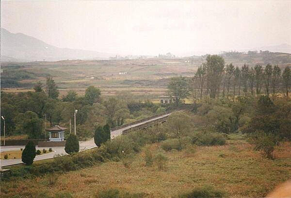
The "Bridge of No Return" in the Demilitarized Zone (DMZ) between North and South Korea was used for prisoner exchanges at the close of the Korean War.
The "Bridge of No Return" in the Demilitarized Zone (DMZ) between North and South Korea was used for prisoner exchanges at the close of the Korean War. • CIA World Factbook • 2020
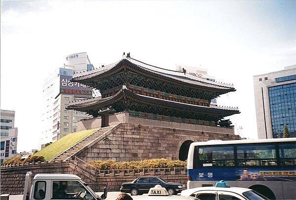
Namdaemun (Sungnyemun) in Seoul was the "Great Southern Gate" in the walls that once surrounded the city. This view was taken before the wooden upper portion was destroyed in a 2008 fire and subsequently restored.
Namdaemun (Sungnyemun) in Seoul was the "Great Southern Gate" in the walls that once surrounded the city. This view was taken before the wooden upper portion was destroyed in a 2008 fire and subsequently restored. • CIA World Factbook • 2020
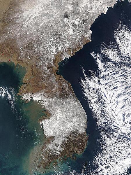
The central provinces of South Korea were crippled when heavy snow closed roads throughout the region, including many in the country's capital, Seoul. More snow fell on 6 March 2004, than ever recorded for a single March day in Korea since record keeping began in 1904. According to news reports, the city of Taejon received 49 cm (19 in) of snow on Friday, with an additional 15 cm (6 in) forecast for Saturday. The image shows the storm moving away from the peninsula on 7 March 2004, leaving much of South Korea under a blanket of snow. Image courtesy of NASA.
The central provinces of South Korea were crippled when heavy snow closed roads throughout the region, including many in the country's capital, Seoul. More snow fell on 6 March 2004, than ever recorded for a single March day in Korea since record keeping began in 1904. According to news reports, the city of Taejon received 49 cm (19 in) of snow on Friday, with an additional 15 cm (6 in) forecast for Saturday. The image shows the storm moving away from the peninsula on 7 March 2004, leaving much of South Korea under a blanket of snow. Image courtesy of NASA. • CIA World Factbook • 2020
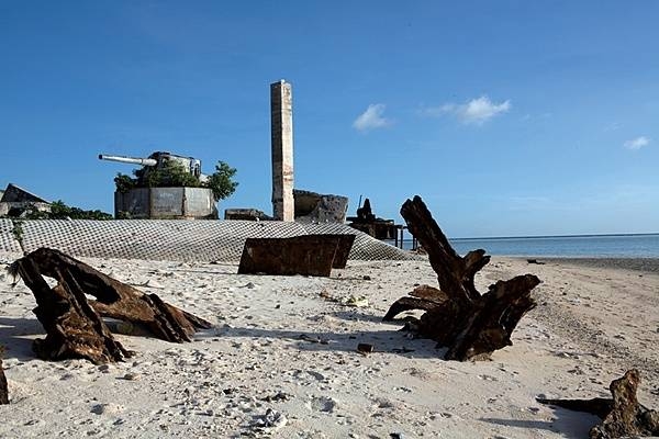
The remains of a Japanese 8-inch coastal defense gun mount sit on the point at Green Beach, Betio Island. Rising above the sand with its muzzle pointed inland, this was one of four 8-inch guns the Japanese emplaced on the island. Shrubs have overtaken the concrete and steel, and hundreds of red crabs race throughout the battlefield debris. Other than some graffiti and weathering, the area remains as it was following the Battle of Tarawa. Photo courtesy of the US Marine Corps/ Cpl. Aaron Hostutler.
The remains of a Japanese 8-inch coastal defense gun mount sit on the point at Green Beach, Betio Island. Rising above the sand with its muzzle pointed inland, this was one of four 8-inch guns the Japanese emplaced on the island. Shrubs have overtaken the concrete and steel, and hundreds of red crabs race throughout the battlefield debris. Other than some graffiti and weathering, the area remains as it was following the Battle of Tarawa. Photo courtesy of the US Marine Corps/ Cpl. Aaron Hostutler. • CIA World Factbook • 2020
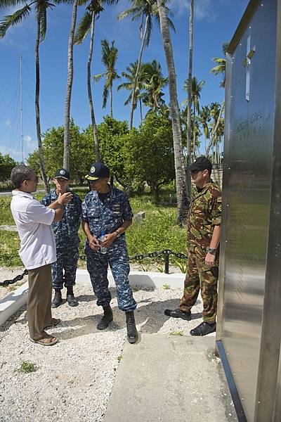
New Zealand High Commissioner of Tarawa Michael Wehi Mailetonga Walsh explains the Betio Memorial to Adm. Cecil D. Haney, commander of the US Pacific Fleet, during his visit to the Republic of Kiribati for Pacific Partnership 2013, 17 July 2013. The memorial is to 22 New Zealand, British, and Australian coastwatchers held prisoner and murdered by Imperial Japanese forces on Betio Island, Tarawa atoll, Kiribati. Photo courtesy of the US Navy/ Mass Communication Specialist 2nd Class Carlos M. Vazquez II.
New Zealand High Commissioner of Tarawa Michael Wehi Mailetonga Walsh explains the Betio Memorial to Adm. Cecil D. Haney, commander of the US Pacific Fleet, during his visit to the Republic of Kiribati for Pacific Partnership 2013, 17 July 2013. The memorial is to 22 New Zealand, British, and Australian coastwatchers held prisoner and murdered by Imperial Japanese forces on Betio Island, Tarawa atoll, Kiribati. Photo courtesy of the US Navy/ Mass Communication Specialist 2nd Class Carlos M. Vazquez II. • CIA World Factbook • 2020
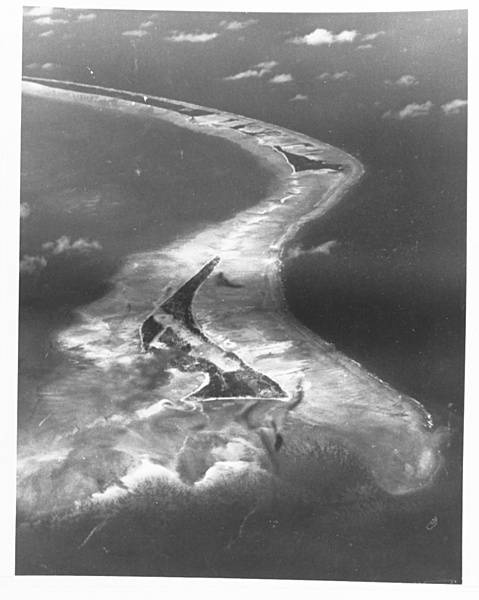
An aerial photograph of the south side of Tarawa Atoll, taken by Navy Squadron VC-24 on 9 September 1943, from an altitude of 3,660 m (12,000 ft). Betio Island is in the foreground, with Bairiki and Eita Islands beyond. The Battle of Tarawa took place on 20 November 1943 largely on Betio Island. Photo courtesy of the US Navy.
An aerial photograph of the south side of Tarawa Atoll, taken by Navy Squadron VC-24 on 9 September 1943, from an altitude of 3,660 m (12,000 ft). Betio Island is in the foreground, with Bairiki and Eita Islands beyond. The Battle of Tarawa took place on 20 November 1943 largely on Betio Island. Photo courtesy of the US Navy. • CIA World Factbook • 2020
10 photos available
View All Photos→Data sources: World Bank, UN Data • Updated daily •Learn about our data