›››
Kazakhstan
Kazakhstan
Population
20.6M
Rank #63Source: World Bank
Capital
Astana
Source: REST Countries
Region
Europe
Europe & Central Asia
Source: REST Countries
GDP (Nominal)
$291.48B
Rank #48Source: World Bank
Land Area
2.7M km²
Rank #9Source: REST Countries
Life Expectancy
74.402 yrs
Source: World Bank
Historical Trends
Population Trend (5-Year)
Source: World Bank
GDP Trend (5-Year, Nominal USD)
Source: World Bank
Geography
Area: 2,724,900 km²
Landlocked: Yes
Independent: Yes
Climate: continental, cold winters and hot summers, arid and semiarid
Terrain: vast flat steppe extending from the Volga in the west to the Altai Mountains in the east and from the plains of western Siberia in the north to oases and deserts of Central Asia in the south
Elevation: mean elevation: 387 m lowest point: Vpadina Kaundy -132 m highest point: Khan Tangiri Shyngy (Pik Khan-Tengri) 6,995 m
Natural Hazards: earthquakes in the south; mudslides around Almaty
Environmental Issues: radioactive or toxic chemical sites associated with former defense industries and test ranges scattered throughout the country pose health risks for humans and animals; industrial pollution is severe...
Land Use: agricultural land: 77.4% (2011 est.) forest: 1.2% (2011 est.) other: 21.4% (2011 est.)
Geography Note: world's largest landlocked country and one of only two landlocked countries in the world that extends into two continents (the other is Azerbaijan); Russia leases approximately 6,000 sq km of...
Natural Resources
major deposits of petroleumnatural gascoaliron oremanganesechrome orenickelcobaltcoppermolybdenum
People & Society
Fertility Rate
3.01
Population
20.6M
Ethnic Groups
Kazakh (Qazaq) (68%)Russian (19.3%)Uzbek (3.2%)Ukrainian (1.5%)Uighur (1.5%)Tatar (1.1%)German (1%)other (4.4%)
Religions
Muslim (70.2%)Christian (26.2%)other (0.2%)atheist (2.8%)unspecified (0.5%)
Economy
GDP per Capita
$14,154.632
GDP per Capita PPP
40,890.932
(2024)
(2024)
GNI per Capita
12,090
(2024)
(2024)
Gini Index
29.2
(2021)
(2021)
Unemployment
4.833%
(2024)
(2024)
Inflation
8.839%
(2024)
(2024)
Public Debt
20.886%
(2023)
(2023)
Energy
Electricity Access
100%
(2023)
(2023)
Renewable Energy
2%
(2021)
(2021)
CO₂ Emissions
258.804 Mt
(2024)
(2024)
Energy Intensity
5.81 MJ/$
(2021)
(2021)
Renewable Electricity
10.998%
(2021)
(2021)
Environment
Forest Coverage
1.312% of land
(2023)
(2023)
Communications
Internet Users
93.392%
(2024)
(2024)
Mobile Penetration
127.115%
(2023)
(2023)
Broadband Subscribers
14.346%
(2023)
(2023)
Transportation
Air Transport Freight
53.083 M ton-km
(2023)
(2023)
Container Port Traffic
Not Available
Airports
89,366.362
Rail Lines
16,005.6 km
Roads Total
94,901.9 km(©IRF)
Military
Military Forces
Armed Forces of the Republic of Kazakhstan: Land Forces, Navy, Air and Air Defense Force; Ministry of Internal Affairs: National Guard, Border Service (includes Coast Guard), State Security Service
Personnel Strength
estimates of the size of the Armed Forces of Kazakhstan vary; approximately 45,000 active duty personnel (25,000 Army; 3,000 Navy; 14,000 Air and Air Defense; 3,000 other)
Military Expenditure (USD)
$1.21B
Military Expenditure (% of GDP)
0.43%
Military Expenditure History
1.1% of GDP (2019) 0.9% of GDP (2018) 0.9% of GDP (2017) 0.9% of GDP (2016) 1.1% of GDP (2015)
Deployments
120 Lebanon (UNIFIL); as of mid-2019, Kazakhstan contributed a brigade to CSTO's Rapid Reaction Force (2020)
Equipment & Inventories
the Kazakh military's inventory is comprised of mostly older Russian and Soviet-era equipment; since 2010, Russia remains by far the leading supplier of weapons systems, but Kazakhstan has also...
Service Age & Obligation
All men 18-27 are required to serve in the military for at least one year.
Education
Pre-Primary Enrollment
74.135%
(2020)
(2020)
Primary Enrollment
97.537%
(2024)
(2024)
Secondary Enrollment
97.199%
(2024)
(2024)
Tertiary Enrollment
53.456%
(2024)
(2024)
Education Spending
4.85% of GDP
(2023)
(2023)
Pupil-Teacher Ratio
17.215:1
(2019)
(2019)
Health
Physicians per 1,000
3.754
(2023)
(2023)
Safe Water Access
97.834%
(2024)
(2024)
Safe Drinking Water
91.545%
(2024)
(2024)
Under-5 Mortality
9.6 per 1,000
(2023)
(2023)
Maternal Mortality (World Bank)
16.403 per 100,000
(2021)
(2021)
Hospital Beds per 1,000
70.275
(2021)
(2021)
UHC Coverage Index
83
(2023)
(2023)
Measles Immunization
98%
(2024)
(2024)
Social Indicators
Extreme Poverty Rate
Not Available
Food Insecurity
2.5%
(2023)
(2023)
Youth NEET Rate
3.81%
(2022)
(2022)
Governance
Women in Government
19.388%
(2024)
(2024)
Voice & Accountability
-1.00
(Weak)
(2023)
(Weak)
(2023)
Political Stability
-0.27
(Below Average)
(2023)
(Below Average)
(2023)
Government Effectiveness
0.15
(Above Average)
(2023)
(Above Average)
(2023)
Regulatory Quality
0.07
(Above Average)
(2023)
(Above Average)
(2023)
Rule of Law
-0.45
(Below Average)
(2023)
(Below Average)
(2023)
Control of Corruption
-0.27
(Below Average)
(2023)
(Below Average)
(2023)
Government
Government Type
presidential republic
Legal System
civil law system influenced by Roman-Germanic law and by the theory and practice of the Russian Federation
Executive Branch
chief of state: President Kasym-Zhomart TOKAYEV (since 20 March 2019); note - Nursultan NAZARBAYEV, who was president since 24 April 1990 (and in power since 22 June 1989 under the Soviet period),...
Legislative Branch
description: bicameral Parliament consists of:Senate (49 seats; 34 members indirectly elected by majority 2-round vote by the oblast-level assemblies and 15 members appointed by decree of the...
Judicial Branch
highest courts: Supreme Court of the Republic (consists of 44 members); Constitutional Council (consists of the chairman and 6 members) judge selection and term of office: Supreme Court judges...
National Symbols
Flag Description
a gold sun with 32 rays above a soaring golden steppe eagle, both centered on a sky blue background; the hoist side displays a national ornamental pattern "koshkar-muiz" (the horns of the ram) in...
National Symbols
golden eagle; national colors: blue, yellow
National Anthem
name: "Menin Qazaqstanim" (My Kazakhstan) lyrics/music: Zhumeken NAZHIMEDENOV and Nursultan NAZARBAYEV/Shamshi KALDAYAKOV note: adopted 2006; President Nursultan NAZARBAYEV played a role in revising...
Safety
Homicide Rate
2.551 per 100,000
(2022)
(2022)
Travel Information
Language(s): Kazakh, Russian
Currency: KZT (₸)
Timezone(s): UTC +05:00 to +06:00
Landlocked: Yes
Independent: Yes
Driving Side: Right
Calling Code: +7
Car Sign: KZ
Week Starts: Monday
Photos
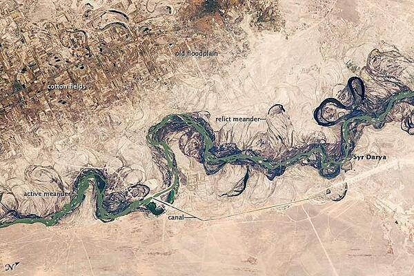
Central Asia's most important cotton-growing region is concentrated in the floodplain of the Syr Darya. The floodplain is shown here as a tangle of twisting meanders and loops (image center). The darkest areas are brushy vegetation along the present course (filled with blue-green water); wisps of vegetation are also visible along flanking swampy depressions, or sloughs. An older floodplain appears as more diffuse dark vegetation (image upper left), where relict bends are overlain by a rectangular pattern of cotton fields. The straight channel of a new diversion canal can be seen along the east bank of the river. Half the river flow is controlled from reservoirs, and half from direct water take-off from canals. In contrast to the intensive agricultural use of water shown here, water control in the mountain valleys upstream is oriented more toward power generation. The river flows for 2,200 km (1,370 mi), from the Tien Shan Mountains west and northwest to the Aral Sea. Control of the river is vested in the Syr Darya Basin Water Organization, run by nations with territory in the watershed. Some of the organization's main efforts include accurate gauging of water use and repair of canals to reduce widespread water leakage. Photo courtesy of NASA.
Central Asia's most important cotton-growing region is concentrated in the floodplain of the Syr Darya. The floodplain is shown here as a tangle of twisting meanders and loops (image center). The darkest areas are brushy vegetation along the present course (filled with blue-green water); wisps of vegetation are also visible along flanking swampy depressions, or sloughs. An older floodplain appears as more diffuse dark vegetation (image upper left), where relict bends are overlain by a rectangular pattern of cotton fields. The straight channel of a new diversion canal can be seen along the east bank of the river. Half the river flow is controlled from reservoirs, and half from direct water take-off from canals. In contrast to the intensive agricultural use of water shown here, water control in the mountain valleys upstream is oriented more toward power generation.
The river flows for 2,200 km (1,370 mi), from the Tien Shan Mountains west and northwest to the Aral Sea. Control of the river is vested in the Syr Darya Basin Water Organization, run by nations with territory in the watershed. Some of the organization's main efforts include accurate gauging of water use and repair of canals to reduce widespread water leakage. Photo courtesy of NASA. • CIA World Factbook • 2020
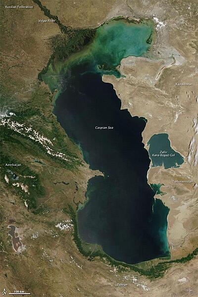
Measured by surface area, the Caspian Sea is the world's largest inland water body. It covers roughly 371,000 sq km (143,200 sq mi) and borders five countries. To the ancient Greeks and Persians, the lake's immense size suggested it was an ocean, hence its name. A large expanse of clear sky permitted this natural-color satellite image of the entire water body. The color of the Caspian Sea darkens from north to south, thanks to changes in depth and perhaps sediment and other runoff. The northern part of the lake is just 5 to 6 m (16 to 20 ft) deep. The southern end, however, plunges more than 1,000 m (3,300 ft). Just as the lake reaches a greater depth in the south, the nearby land reaches a greater height. The mountains of northern Iran line the southern end of the giant lake, and emerald green vegetation clings to those mountain slopes. In marked contrast to the mountains, sand seas line the southeastern and northern perimeters of the lake, and marshes occur along the lake shores in Azerbaijan to the west. Multiple rivers empty into the Caspian Sea, the Volga being the largest. Lacking an outlet, the Caspian Sea loses water only by evaporation, leading to the accumulation of salt. Although a lake, the Caspian is not a freshwater lake; the water delivered by the Volga River minimizes the lake's salt content at the northern end, but the Caspian grows more saline to the south. Kara-Bogaz-Gol is a saline inlet along the lake's eastern perimeter. Image courtesy of NASA.
Measured by surface area, the Caspian Sea is the world's largest inland water body. It covers roughly 371,000 sq km (143,200 sq mi) and borders five countries. To the ancient Greeks and Persians, the lake's immense size suggested it was an ocean, hence its name. A large expanse of clear sky permitted this natural-color satellite image of the entire water body. The color of the Caspian Sea darkens from north to south, thanks to changes in depth and perhaps sediment and other runoff. The northern part of the lake is just 5 to 6 m (16 to 20 ft) deep. The southern end, however, plunges more than 1,000 m (3,300 ft). Just as the lake reaches a greater depth in the south, the nearby land reaches a greater height. The mountains of northern Iran line the southern end of the giant lake, and emerald green vegetation clings to those mountain slopes. In marked contrast to the mountains, sand seas line the southeastern and northern perimeters of the lake, and marshes occur along the lake shores in Azerbaijan to the west. Multiple rivers empty into the Caspian Sea, the Volga being the largest. Lacking an outlet, the Caspian Sea loses water only by evaporation, leading to the accumulation of salt. Although a lake, the Caspian is not a freshwater lake; the water delivered by the Volga River minimizes the lake's salt content at the northern end, but the Caspian grows more saline to the south. Kara-Bogaz-Gol is a saline inlet along the lake's eastern perimeter. Image courtesy of NASA. • CIA World Factbook • 2020
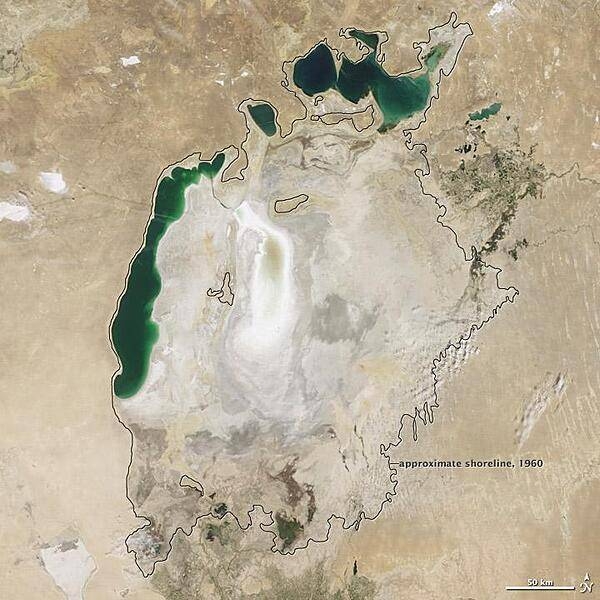
Throughout the first half of the 20th century, the Aral Sea was the world's fourth-largest lake. In the 1960s, the Soviet Union began a massive irrigation project in what are now Kazakhstan, Uzbekistan, and Turkmenistan, diverting water from the rivers that feed the Aral Sea to irrigate farmland. As its water levels dropped, the lake began splitting into smaller pieces: the Northern (Small) Aral Sea and the Southern (Large) Aral Sea. The Southern Aral Sea further split into eastern and western lobes. In August 2009 when this photo was taken, the Northern Aral Sea (upper right) still appeared healthy, the Southern Aral Sea consisted of two isolated water bodies: an irregular oval shape directly southwest of the Northern Aral Sea, and the long, thin remainder of the Southern Aral Sea's far western lobe. Much of what finally doomed the Southern Aral Sea was an attempt to save its neighbor to the north. In 2005, Kazakhstan built the Kok-Aral Dam between the lake's northern and southern portions to preserve water levels in the north. The Northern Aral Sea actually exceeded expectations with the speed of its recovery, but the dam ended prospects for a recovery of the Southern Aral Sea, which some authorities already regarded as beyond help. Lake sediments from this depleted water body have provided ample material for frequent dust storms. Image courtesy of NASA.
Throughout the first half of the 20th century, the Aral Sea was the world's fourth-largest lake. In the 1960s, the Soviet Union began a massive irrigation project in what are now Kazakhstan, Uzbekistan, and Turkmenistan, diverting water from the rivers that feed the Aral Sea to irrigate farmland. As its water levels dropped, the lake began splitting into smaller pieces: the Northern (Small) Aral Sea and the Southern (Large) Aral Sea. The Southern Aral Sea further split into eastern and western lobes. In August 2009 when this photo was taken, the Northern Aral Sea (upper right) still appeared healthy, the Southern Aral Sea consisted of two isolated water bodies: an irregular oval shape directly southwest of the Northern Aral Sea, and the long, thin remainder of the Southern Aral Sea's far western lobe. Much of what finally doomed the Southern Aral Sea was an attempt to save its neighbor to the north. In 2005, Kazakhstan built the Kok-Aral Dam between the lake's northern and southern portions to preserve water levels in the north. The Northern Aral Sea actually exceeded expectations with the speed of its recovery, but the dam ended prospects for a recovery of the Southern Aral Sea, which some authorities already regarded as beyond help. Lake sediments from this depleted water body have provided ample material for frequent dust storms. Image courtesy of NASA. • CIA World Factbook • 2020
CIA World Factbook • 2020
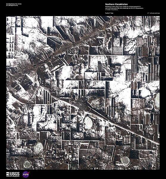
Mimicking a cubist collage, linear windbreaks of densely planted trees surround farmsteads in this winter landscape near the city of Komsomolets in northern Kazakhstan. Image courtesy of USGS.
Mimicking a cubist collage, linear windbreaks of densely planted trees surround farmsteads in this winter landscape near the city of Komsomolets in northern Kazakhstan. Image courtesy of USGS. • CIA World Factbook • 2020
CIA World Factbook • 2020
7 photos available
View All Photos→Data sources: World Bank, UN Data • Updated daily •Learn about our data