›››
Kazakhstan — Media Gallery
7 items available (flags, maps, photos)
Photos
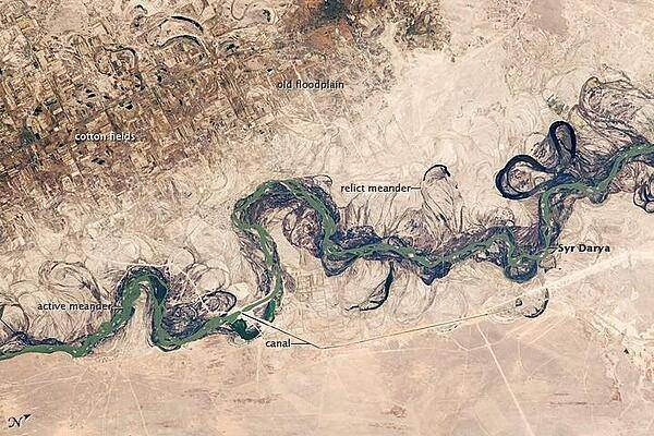
Central Asia's most important cotton-growing region is concentrated in the floodplain of the Syr Darya. The floodplain is shown here as a tangle of twisting meanders and loops (image center). The darkest areas are brushy vegetation along the present course (filled with blue-green water); wisps of vegetation are also visible along flanking swampy depressions, or sloughs. An older floodplain appears as more diffuse dark vegetation (image upper left), where relict bends are overlain by a rectangular pattern of cotton fields. The straight channel of a new diversion canal can be seen along the east bank of the river. Half the river flow is controlled from reservoirs, and half from direct water take-off from canals. In contrast to the intensive agricultural use of water shown here, water control in the mountain valleys upstream is oriented more toward power generation. The river flows for 2,200 km (1,370 mi), from the Tien Shan Mountains west and northwest to the Aral Sea. Control of the river is vested in the Syr Darya Basin Water Organization, run by nations with territory in the watershed. Some of the organization's main efforts include accurate gauging of water use and repair of canals to reduce widespread water leakage. Photo courtesy of NASA.
Central Asia's most important cotton-growing region is concentrated in the floodplain of the Syr Darya. The floodplain is shown here as a tangle of twisting meanders and loops (image center). The darkest areas are brushy vegetation along the present course (filled with blue-green water); wisps of vegetation are also visible along flanking swampy depressions, or sloughs. An older floodplain appears as more diffuse dark vegetation (image upper left), where relict bends are overlain by a rectangular pattern of cotton fields. The straight channel of a new diversion canal can be seen along the east bank of the river. Half the river flow is controlled from reservoirs, and half from direct water take-off from canals. In contrast to the intensive agricultural use of water shown here, water control in the mountain valleys upstream is oriented more toward power generation.
The river flows for 2,200 km (1,370 mi), from the Tien Shan Mountains west and northwest to the Aral Sea. Control of the river is vested in the Syr Darya Basin Water Organization, run by nations with territory in the watershed. Some of the organization's main efforts include accurate gauging of water use and repair of canals to reduce widespread water leakage. Photo courtesy of NASA. • CIA World Factbook • 2020
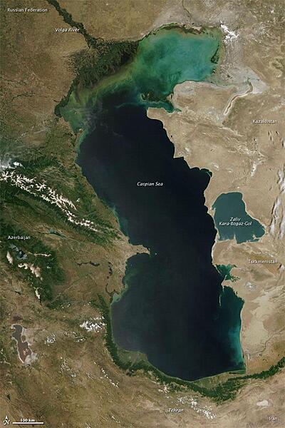
Measured by surface area, the Caspian Sea is the world's largest inland water body. It covers roughly 371,000 sq km (143,200 sq mi) and borders five countries. To the ancient Greeks and Persians, the lake's immense size suggested it was an ocean, hence its name. A large expanse of clear sky permitted this natural-color satellite image of the entire water body. The color of the Caspian Sea darkens from north to south, thanks to changes in depth and perhaps sediment and other runoff. The northern part of the lake is just 5 to 6 m (16 to 20 ft) deep. The southern end, however, plunges more than 1,000 m (3,300 ft). Just as the lake reaches a greater depth in the south, the nearby land reaches a greater height. The mountains of northern Iran line the southern end of the giant lake, and emerald green vegetation clings to those mountain slopes. In marked contrast to the mountains, sand seas line the southeastern and northern perimeters of the lake, and marshes occur along the lake shores in Azerbaijan to the west. Multiple rivers empty into the Caspian Sea, the Volga being the largest. Lacking an outlet, the Caspian Sea loses water only by evaporation, leading to the accumulation of salt. Although a lake, the Caspian is not a freshwater lake; the water delivered by the Volga River minimizes the lake's salt content at the northern end, but the Caspian grows more saline to the south. Kara-Bogaz-Gol is a saline inlet along the lake's eastern perimeter. Image courtesy of NASA.
Measured by surface area, the Caspian Sea is the world's largest inland water body. It covers roughly 371,000 sq km (143,200 sq mi) and borders five countries. To the ancient Greeks and Persians, the lake's immense size suggested it was an ocean, hence its name. A large expanse of clear sky permitted this natural-color satellite image of the entire water body. The color of the Caspian Sea darkens from north to south, thanks to changes in depth and perhaps sediment and other runoff. The northern part of the lake is just 5 to 6 m (16 to 20 ft) deep. The southern end, however, plunges more than 1,000 m (3,300 ft). Just as the lake reaches a greater depth in the south, the nearby land reaches a greater height. The mountains of northern Iran line the southern end of the giant lake, and emerald green vegetation clings to those mountain slopes. In marked contrast to the mountains, sand seas line the southeastern and northern perimeters of the lake, and marshes occur along the lake shores in Azerbaijan to the west. Multiple rivers empty into the Caspian Sea, the Volga being the largest. Lacking an outlet, the Caspian Sea loses water only by evaporation, leading to the accumulation of salt. Although a lake, the Caspian is not a freshwater lake; the water delivered by the Volga River minimizes the lake's salt content at the northern end, but the Caspian grows more saline to the south. Kara-Bogaz-Gol is a saline inlet along the lake's eastern perimeter. Image courtesy of NASA. • CIA World Factbook • 2020
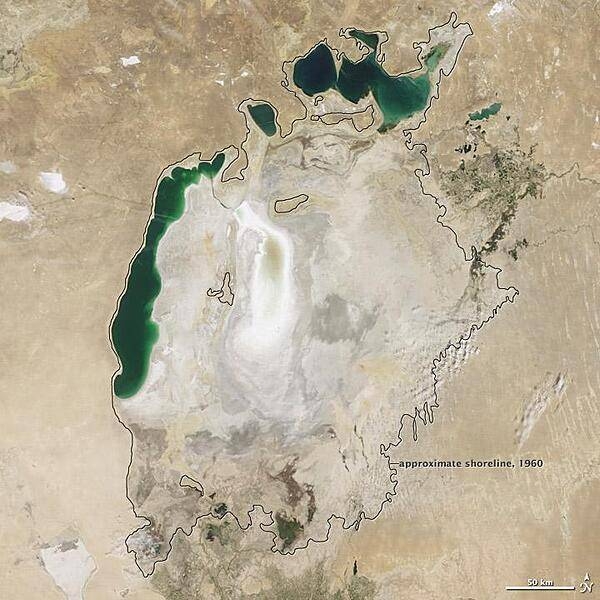
Throughout the first half of the 20th century, the Aral Sea was the world's fourth-largest lake. In the 1960s, the Soviet Union began a massive irrigation project in what are now Kazakhstan, Uzbekistan, and Turkmenistan, diverting water from the rivers that feed the Aral Sea to irrigate farmland. As its water levels dropped, the lake began splitting into smaller pieces: the Northern (Small) Aral Sea and the Southern (Large) Aral Sea. The Southern Aral Sea further split into eastern and western lobes. In August 2009 when this photo was taken, the Northern Aral Sea (upper right) still appeared healthy, the Southern Aral Sea consisted of two isolated water bodies: an irregular oval shape directly southwest of the Northern Aral Sea, and the long, thin remainder of the Southern Aral Sea's far western lobe. Much of what finally doomed the Southern Aral Sea was an attempt to save its neighbor to the north. In 2005, Kazakhstan built the Kok-Aral Dam between the lake's northern and southern portions to preserve water levels in the north. The Northern Aral Sea actually exceeded expectations with the speed of its recovery, but the dam ended prospects for a recovery of the Southern Aral Sea, which some authorities already regarded as beyond help. Lake sediments from this depleted water body have provided ample material for frequent dust storms. Image courtesy of NASA.
Throughout the first half of the 20th century, the Aral Sea was the world's fourth-largest lake. In the 1960s, the Soviet Union began a massive irrigation project in what are now Kazakhstan, Uzbekistan, and Turkmenistan, diverting water from the rivers that feed the Aral Sea to irrigate farmland. As its water levels dropped, the lake began splitting into smaller pieces: the Northern (Small) Aral Sea and the Southern (Large) Aral Sea. The Southern Aral Sea further split into eastern and western lobes. In August 2009 when this photo was taken, the Northern Aral Sea (upper right) still appeared healthy, the Southern Aral Sea consisted of two isolated water bodies: an irregular oval shape directly southwest of the Northern Aral Sea, and the long, thin remainder of the Southern Aral Sea's far western lobe. Much of what finally doomed the Southern Aral Sea was an attempt to save its neighbor to the north. In 2005, Kazakhstan built the Kok-Aral Dam between the lake's northern and southern portions to preserve water levels in the north. The Northern Aral Sea actually exceeded expectations with the speed of its recovery, but the dam ended prospects for a recovery of the Southern Aral Sea, which some authorities already regarded as beyond help. Lake sediments from this depleted water body have provided ample material for frequent dust storms. Image courtesy of NASA. • CIA World Factbook • 2020
CIA World Factbook • 2020
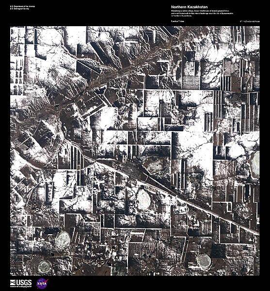
Mimicking a cubist collage, linear windbreaks of densely planted trees surround farmsteads in this winter landscape near the city of Komsomolets in northern Kazakhstan. Image courtesy of USGS.
Mimicking a cubist collage, linear windbreaks of densely planted trees surround farmsteads in this winter landscape near the city of Komsomolets in northern Kazakhstan. Image courtesy of USGS. • CIA World Factbook • 2020
CIA World Factbook • 2020
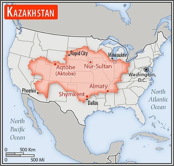
Area comparison map
Area comparison map • CIA World Factbook • 2020
Media source: CIA World Factbook (2020) — Public Domain