›››
Libya
Libya
Population
7.4M
Rank #105Source: World Bank
Capital
Tripoli
Source: REST Countries
Region
Africa
Middle East, North Africa, Afghanistan & Pakistan
Source: REST Countries
GDP (Nominal)
$48.49B
Rank #96Source: World Bank
Land Area
1.8M km²
Rank #17Source: REST Countries
Life Expectancy
69.339 yrs
Source: World Bank
Historical Trends
Population Trend (5-Year)
Source: World Bank
GDP Trend (5-Year, Nominal USD)
Source: World Bank
Geography
Area: 1,759,540 km²
Landlocked: No
Independent: Yes
Climate: Mediterranean along coast; dry, extreme desert interior
Terrain: mostly barren, flat to undulating plains, plateaus, depressions
Elevation: mean elevation: 423 m lowest point: Sabkhat Ghuzayyil -47 m highest point: Bikku Bitti 2,267 m
Natural Hazards: hot, dry, dust-laden ghibli is a southern wind lasting one to four days in spring and fall; dust storms, sandstorms
Environmental Issues: desertification; limited natural freshwater resources; the Great Manmade River Project, the largest water development scheme in the world, brings water from large aquifers under the Sahara to coastal...
Land Use: agricultural land: 8.8% (2011 est.) forest: 0.1% (2011 est.) other: 91.1% (2011 est.)
Geography Note: note 1: more than 90% of the country is desert or semidesertnote 2: the volcano Waw an Namus lies in south central Libya in the middle of the Sahara; the caldera is an oasis - the name means "oasis...
Natural Resources
petroleumnatural gasgypsum
People & Society
Fertility Rate
2.35
Population
7.4M
Ethnic Groups
Berber and Arab (97%)other (3%)
Religions
Muslim (official; virtually all Sunni) (96.6%)Christian (2.7%)Buddhist (0.3%)unafilliated (0.2%)
Economy
GDP per Capita
$6,569.164
GDP per Capita PPP
14,303.809
(2024)
(2024)
GNI per Capita
6,890
(2024)
(2024)
Gini Index
Not Available
Unemployment
19.085%
(2024)
(2024)
Inflation
2.126%
(2024)
(2024)
Public Debt
Not Available
Energy
Electricity Access
73.2%
(2023)
(2023)
Renewable Energy
3.1%
(2021)
(2021)
CO₂ Emissions
63.953 Mt
(2024)
(2024)
Energy Intensity
5.26 MJ/$
(2021)
(2021)
Renewable Electricity
0.022%
(2021)
(2021)
Environment
Forest Coverage
0.123% of land
(2023)
(2023)
Communications
Internet Users
88.499%
(2023)
(2023)
Mobile Penetration
192.973%
(2022)
(2022)
Broadband Subscribers
4.518%
(2022)
(2022)
Transportation
Air Transport Freight
60.053 M ton-km
(2023)
(2023)
Container Port Traffic
271,230.6 TEU
(2019)
(2019)
Airports
11,246
Rail Lines
N/A
Roads Total
N/A
Military
Military Forces
note - in transition; the Government of National Accord (GNA) has various ground, air, naval, and coast guard forces under its command; the forces are comprised of a mix of semi-regular military...
Personnel Strength
the sizes of the forces of both the Government of National Accord and the Libyan National Army are unknown
Military Expenditure (USD)
$1.57B
Military Expenditure (% of GDP)
5.29%
Equipment & Inventories
both the forces of the Government of National Accord and the Libyan National Army are largely equipped with weapons of Russian or Soviet origin (2020)
Health
Physicians per 1,000
2.042
(2017)
(2017)
Safe Water Access
96.355%
(2024)
(2024)
Safe Drinking Water
Not Available
Under-5 Mortality
30.8 per 1,000
(2023)
(2023)
Maternal Mortality (World Bank)
17.324 per 100,000
(2021)
(2021)
Hospital Beds per 1,000
72.178
(2021)
(2021)
UHC Coverage Index
71
(2023)
(2023)
Measles Immunization
86%
(2024)
(2024)
Social Indicators
Extreme Poverty Rate
Not Available
Food Insecurity
16.5%
(2023)
(2023)
Youth NEET Rate
48.7%
(2012)
(2012)
Governance
Women in Government
16.471%
(2024)
(2024)
Voice & Accountability
-1.39
(Weak)
(2023)
(Weak)
(2023)
Political Stability
-2.17
(Weak)
(2023)
(Weak)
(2023)
Government Effectiveness
-1.64
(Weak)
(2023)
(Weak)
(2023)
Regulatory Quality
-1.95
(Weak)
(2023)
(Weak)
(2023)
Rule of Law
-1.77
(Weak)
(2023)
(Weak)
(2023)
Control of Corruption
-1.52
(Weak)
(2023)
(Weak)
(2023)
Government
Government Type
in transition
Legal System
Libya's post-revolution legal system is in flux and driven by state and non-state entities
Executive Branch
chief of state: Chairman, Presidential Council, Fayiz al-SARAJ (since December 2015) head of government: Prime Minister Fayiz al-SARAJ (since December 2015) cabinet: GNA Presidency Council (pending...
Legislative Branch
description: unicameral House of Representatives (Majlis Al Nuwab) or HoR (200 seats including 32 reserved for women; members directly elected by majority vote; member term NA); note - the High...
Judicial Branch
NA; note - government is in transition
National Symbols
Flag Description
three horizontal bands of red (top), black (double width), and green with a white crescent and star centered on the black stripe; the National Transitional Council reintroduced this flag design of...
National Symbols
star and crescent, hawk; national colors: red, black, green
National Anthem
name: Libya, Libya, Libya lyrics/music: Al Bashir AL AREBI/Mohamad Abdel WAHAB note: also known as "Ya Beladi" or "Oh, My Country!"; adopted 1951; readopted 2011 with some modification to the lyrics;...
Travel Information
Language(s): Arabic
Currency: LYD (ل.د)
Timezone(s): UTC+01:00
Landlocked: No
Independent: Yes
Driving Side: Right
Calling Code: +218
Car Sign: LAR
Week Starts: Sunday
Photos
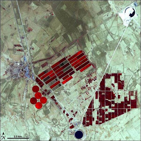
In the 1950s, oil exploration in Libya revealed that the country also had huge aquifers lurking underneath its scorching sands. Libyans weighed the costs of bringing water up from the aquifers against transporting water from Europe or the desalination of salt water, and chose the aquifers as the most cost-effective option. This false-color satellite image shows part of Libya's massive water project, known as the Grand Omar Mukhtar, near the city of Suluq. Libyans plan to make the Grand Omar Mukhtar the country's largest man-made reservoir. Water residing in reservoirs appears twice in this image, in the upper right and at the bottom. In both cases, the water appears dark blue. In this image, vegetation appears red, and the brighter the red, the more robust the vegetation. In this arid place, the vegetation results from irrigated agriculture, so the areas of red appear in the crisp geometric shapes of carefully planned fields. The circular spots of red are the result of result of center-pivot irrigation. Image courtesy of NASA.
In the 1950s, oil exploration in Libya revealed that the country also had huge aquifers lurking underneath its scorching sands. Libyans weighed the costs of bringing water up from the aquifers against transporting water from Europe or the desalination of salt water, and chose the aquifers as the most cost-effective option. This false-color satellite image shows part of Libya's massive water project, known as the Grand Omar Mukhtar, near the city of Suluq. Libyans plan to make the Grand Omar Mukhtar the country's largest man-made reservoir. Water residing in reservoirs appears twice in this image, in the upper right and at the bottom. In both cases, the water appears dark blue. In this image, vegetation appears red, and the brighter the red, the more robust the vegetation. In this arid place, the vegetation results from irrigated agriculture, so the areas of red appear in the crisp geometric shapes of carefully planned fields. The circular spots of red are the result of result of center-pivot irrigation. Image courtesy of NASA. • CIA World Factbook • 2020
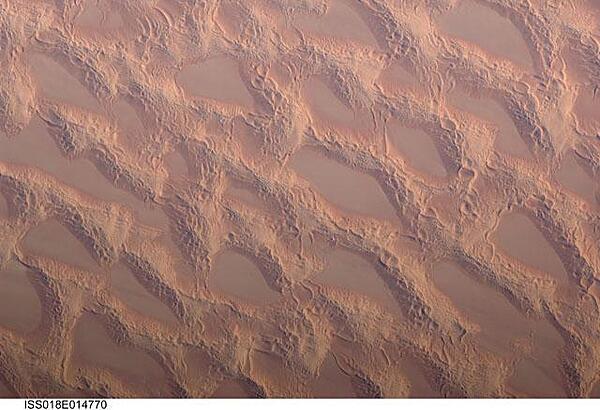
Photo shows classic large and small sand masses of the central Sahara Desert, where wind is a more powerful land-shaping agent than water. "Draa" dunes (from the Arabic for "arm") are very large masses of sand, and they appear here as the broad network of yellow-orange sand masses, with smooth-floored, almost sand-free basins between them. These sand masses lie in the western part of Libya's vast Marzuq Sand Sea. Geologists think that the draa of the Marzuq were probably formed by winds different from the prevailing north-northeast winds of today. Numerous smaller dunes have developed on the backs of the draa. Three distinct dune types are visible: longitudinal dunes, which are more or less parallel with the north winds; transverse dunes, which are usually more curved and formed at right angles to the wind; and star dunes, in which several linear arms converge towards a single peak. Image courtesy of NASA.
Photo shows classic large and small sand masses of the central Sahara Desert, where wind is a more powerful land-shaping agent than water. "Draa" dunes (from the Arabic for "arm") are very large masses of sand, and they appear here as the broad network of yellow-orange sand masses, with smooth-floored, almost sand-free basins between them. These sand masses lie in the western part of Libya's vast Marzuq Sand Sea. Geologists think that the draa of the Marzuq were probably formed by winds different from the prevailing north-northeast winds of today. Numerous smaller dunes have developed on the backs of the draa. Three distinct dune types are visible: longitudinal dunes, which are more or less parallel with the north winds; transverse dunes, which are usually more curved and formed at right angles to the wind; and star dunes, in which several linear arms converge towards a single peak. Image courtesy of NASA. • CIA World Factbook • 2020
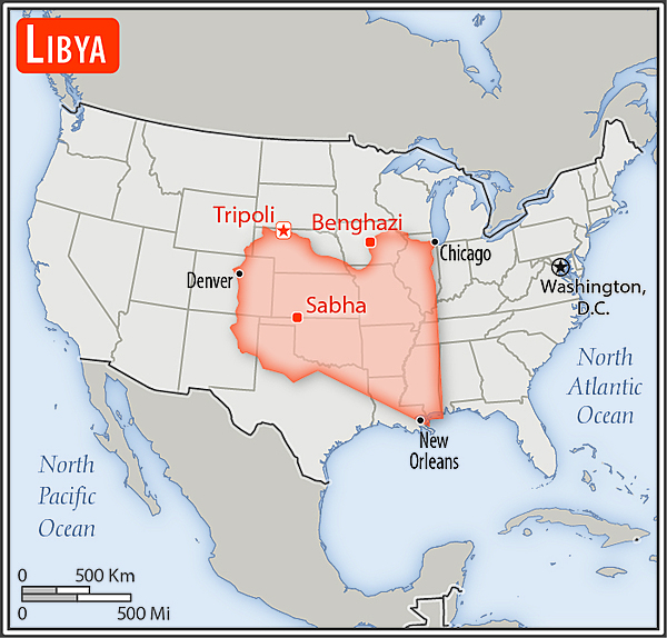
Area comparison map
Area comparison map • CIA World Factbook • 2020
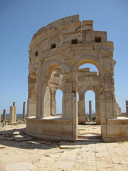
Leptis Magna, about 100 km (60 mi) east of Tripoli, is recognized as one of the most complete and best-preserved Roman ruins in the Mediterranean area.
Leptis Magna, about 100 km (60 mi) east of Tripoli, is recognized as one of the most complete and best-preserved Roman ruins in the Mediterranean area. • CIA World Factbook • 2020
CIA World Factbook • 2020
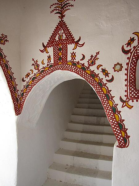
The traditionally decorated mud brick architecture of Ghadames' Old City is designed for natural cooling. Buildings are built directly adjacent to each other, which insulates the streets and living spaces below from the beating sun.
The traditionally decorated mud brick architecture of Ghadames' Old City is designed for natural cooling. Buildings are built directly adjacent to each other, which insulates the streets and living spaces below from the beating sun. • CIA World Factbook • 2020
18 photos available
View All Photos→Data sources: World Bank, UN Data • Updated daily •Learn about our data