›››
Mexico
Mexico
Population
130.9M
Rank #11Source: World Bank
Capital
Mexico City
Source: REST Countries
Region
Americas
Latin America & Caribbean
Source: REST Countries
GDP (Nominal)
$1.86T
Rank #13Source: World Bank
Land Area
2.0M km²
Rank #14Source: REST Countries
Life Expectancy
75.069 yrs
Source: World Bank
Historical Trends
Population Trend (5-Year)
Source: World Bank
GDP Trend (5-Year, Nominal USD)
Source: World Bank
Geography
Area: 1,964,375 km²
Landlocked: No
Independent: Yes
Climate: varies from tropical to desert
Terrain: high, rugged mountains; low coastal plains; high plateaus; desert
Elevation: mean elevation: 1,111 m lowest point: Laguna Salada -10 m highest point: Volcan Pico de Orizaba 5,636 m
Natural Hazards: tsunamis along the Pacific coast, volcanoes and destructive earthquakes in the center and south, and hurricanes on the Pacific, Gulf of Mexico, and Caribbean coastsvolcanism: volcanic activity in the...
Environmental Issues: scarcity of hazardous waste disposal facilities; rural to urban migration; natural freshwater resources scarce and polluted in north, inaccessible and poor quality in center and extreme southeast;...
Land Use: agricultural land: 54.9% (2011 est.) forest: 33.3% (2011 est.) other: 11.8% (2011 est.)
Geography Note: note 1: strategic location on southern border of the US; Mexico is one of the countries along the Ring of Fire, a belt of active volcanoes and earthquake epicenters bordering the Pacific Ocean; up to...
Natural Resources
petroleumsilverantimonycoppergoldleadzincnatural gastimber
People & Society
Fertility Rate
1.91
Population
130.9M
Ethnic Groups
Mestizo (Amerindian-Spanish) (62%)predominantly Amerindian (21%)Amerindian (7%)other (10%)
Religions
Roman Catholic (82.7%)Pentecostal (1.6%)Jehovah's Witness (1.4%)other Evangelical Churches (5%)other (1.9%)none (4.7%)unspecified (2.7%)
Economy
GDP per Capita
$14,185.781
GDP per Capita PPP
26,185.356
(2024)
(2024)
GNI per Capita
12,850
(2024)
(2024)
Gini Index
43.5
(2022)
(2022)
Unemployment
2.678%
(2024)
(2024)
Inflation
4.722%
(2024)
(2024)
Public Debt
45.03%
(2023)
(2023)
Energy
Electricity Access
99.7%
(2023)
(2023)
Renewable Energy
13%
(2021)
(2021)
CO₂ Emissions
475.992 Mt
(2024)
(2024)
Energy Intensity
3 MJ/$
(2022)
(2022)
Renewable Electricity
24.386%
(2021)
(2021)
Environment
Forest Coverage
33.596% of land
(2023)
(2023)
Protected Areas
13.047% of land
(2015)
(2015)
Communications
Internet Users
81.183%
(2023)
(2023)
Mobile Penetration
111.562%
(2023)
(2023)
Broadband Subscribers
20.088%
(2023)
(2023)
Transportation
Air Transport Freight
1,091.48 M ton-km
(2023)
(2023)
Container Port Traffic
8,307,884 TEU
(2022)
(2022)
Airports
556,879
Rail Lines
N/A
Roads Total
407,783.07 km(©IRF)
Military
Military Forces
Secretariat of National Defense (Secretaria de Defensa Nacional, SEDENA): Army (Ejercito), Mexican Air Force (Fuerza Aerea Mexicana, FAM); Secretariat of the Navy (Secretaria de Marina, SEMAR):...
Personnel Strength
the Mexican armed forces have approximately 270,000 active personnel (200,000 Army; 60,000 Navy; 8,000 Air Force); approximately 60-80,000 National Guard
Military Expenditure (USD)
$16.73B
Military Expenditure (% of GDP)
0.89%
Military Expenditure History
0.5% of GDP (2019) 0.5% of GDP (2018) 0.5% of GDP (2017) 0.6% of GDP (2016) 0.7% of GDP (2015)
Equipment & Inventories
the Mexican military inventory includes a mix of domestically-produced and imported equipment from a variety of mostly Western suppliers; since 2010, France, Spain, and the US are the leading...
Service Age & Obligation
18 years of age for compulsory military service (selection for service determined by lottery), conscript service obligation is 12 months; 16 years of age with consent for voluntary enlistment; cadets...
Education
Pre-Primary Enrollment
70.598%
(2020)
(2020)
Primary Enrollment
101.421%
(2023)
(2023)
Secondary Enrollment
102.055%
(2023)
(2023)
Tertiary Enrollment
47.475%
(2023)
(2023)
Education Spending
4.066% of GDP
(2022)
(2022)
Adult Literacy Rate
95.765%
(2024)
(2024)
Pupil-Teacher Ratio
26.552:1
(2017)
(2017)
Health
Physicians per 1,000
2.588
(2022)
(2022)
Safe Water Access
99.541%
(2024)
(2024)
Safe Drinking Water
42.967%
(2024)
(2024)
Under-5 Mortality
12.5 per 1,000
(2023)
(2023)
Maternal Mortality (World Bank)
16.796 per 100,000
(2021)
(2021)
Hospital Beds per 1,000
70.833
(2021)
(2021)
UHC Coverage Index
79
(2023)
(2023)
Measles Immunization
78%
(2024)
(2024)
Social Indicators
Extreme Poverty Rate
2.3%
(2022)
(2022)
Food Insecurity
2.7%
(2023)
(2023)
Youth NEET Rate
5.702%
(2024)
(2024)
Governance
Women in Government
50.2%
(2024)
(2024)
Voice & Accountability
-0.12
(Below Average)
(2023)
(Below Average)
(2023)
Political Stability
-0.63
(Below Average)
(2023)
(Below Average)
(2023)
Government Effectiveness
-0.20
(Below Average)
(2023)
(Below Average)
(2023)
Regulatory Quality
-0.17
(Below Average)
(2023)
(Below Average)
(2023)
Rule of Law
-0.81
(Below Average)
(2023)
(Below Average)
(2023)
Control of Corruption
-1.02
(Weak)
(2023)
(Weak)
(2023)
Government
Government Type
federal presidential republic
Legal System
civil law system with US constitutional law influence; judicial review of legislative acts
Executive Branch
chief of state: President Andres Manuel LOPEZ OBRADOR (since 1 December 2018); note - the president is both chief of state and head of government head of government: President Andres Manuel LOPEZ...
Legislative Branch
description: bicameral National Congress or Congreso de la Union consists of:Senate or Camara de Senadores (128 seats; 96 members directly elected in multi-seat constituencies by simple majority vote...
Judicial Branch
highest courts: Supreme Court of Justice or Suprema Corte de Justicia de la Nacion (consists of the chief justice and 11 justices and organized into civil, criminal, administrative, and labor panels)...
International Organizations
National Symbols
Flag Description
three equal vertical bands of green (hoist side), white, and red; Mexico's coat of arms (an eagle with a snake in its beak perched on a cactus) is centered in the white band; green signifies hope,...
National Symbols
golden eagle; national colors: green, white, red
National Anthem
name: "Himno Nacional Mexicano" (National Anthem of Mexico) lyrics/music: Francisco Gonzalez BOCANEGRA/Jaime Nuno ROCA note: adopted 1943, in use since 1854; also known as "Mexicanos, al grito de...
Safety
Homicide Rate
24.859 per 100,000
(2023)
(2023)
Travel Information
Language(s): Spanish
Currency: MXN ($)
Timezone(s): UTC -06:00 to -08:00
Landlocked: No
Independent: Yes
Driving Side: Right
Calling Code: +52
Car Sign: MEX
Week Starts: Monday
Photos
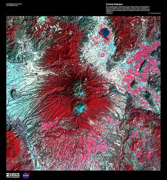
Snow-capped Colima Volcano, the most active volcano in Mexico, rises abruptly from the surrounding landscape in the state of Jalisco in the center of this false-color satellite image. Part of the trans-Mexican volcanic belt, Colima is actually a melding of two volcanoes, the older Nevado de Colima to the north and the younger, historically active Volcan de Colima to the south. Approximately 300,000 people live within 40 km (25 mi) of the volcano earning it designation as a Decade Volcano by the International Association of Volcanology and Chemistry of the Earth's Interior. Legend has it that gods sit atop the volcano on thrones of fire and ice. For other active volcanoes in Mexico, see the Natural hazards-volcanism subfield in the Geography section. Image courtesy of USGS.
Snow-capped Colima Volcano, the most active volcano in Mexico, rises abruptly from the surrounding landscape in the state of Jalisco in the center of this false-color satellite image. Part of the trans-Mexican volcanic belt, Colima is actually a melding of two volcanoes, the older Nevado de Colima to the north and the younger, historically active Volcan de Colima to the south. Approximately 300,000 people live within 40 km (25 mi) of the volcano earning it designation as a Decade Volcano by the International Association of Volcanology and Chemistry of the Earth's Interior. Legend has it that gods sit atop the volcano on thrones of fire and ice. For other active volcanoes in Mexico, see the Natural hazards-volcanism subfield in the Geography section. Image courtesy of USGS. • CIA World Factbook • 2020

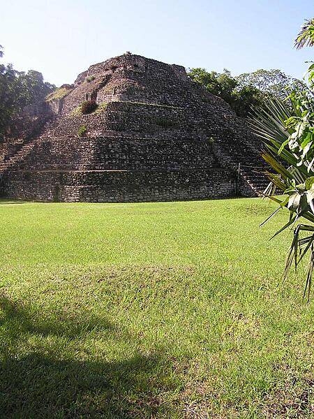
Traces of red paint still visible on Maya carving at Chacchoben.
Traces of red paint still visible on Maya carving at Chacchoben. • CIA World Factbook • 2020
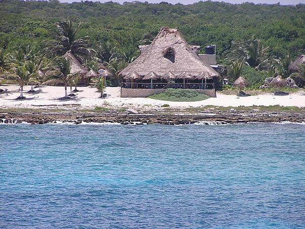
Beach resort of Costa Maya at Quintana Roo.
Beach resort of Costa Maya at Quintana Roo. • CIA World Factbook • 2020

CIA World Factbook • 2020
CIA World Factbook • 2020
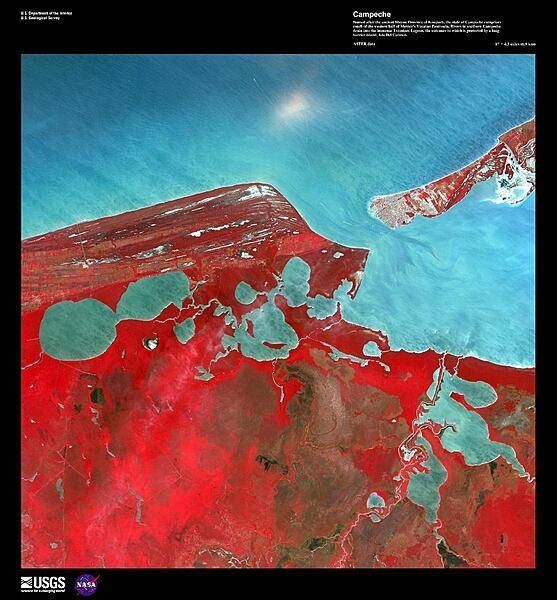
Named after the ancient Mayan Province of Kimpech, the state of Campeche comprises much of the western half of Mexico's Yucatan Peninsula. Rivers in southern Campeche drain into the immense Terminos Lagoon, the entrance to which is protected by a long barrier island, Isla Del Carmen (upper right). In this false-color satellite image the green jungle canopy shows up as bright red. Image courtesy of USGS.
Named after the ancient Mayan Province of Kimpech, the state of Campeche comprises much of the western half of Mexico's Yucatan Peninsula. Rivers in southern Campeche drain into the immense Terminos Lagoon, the entrance to which is protected by a long barrier island, Isla Del Carmen (upper right). In this false-color satellite image the green jungle canopy shows up as bright red. Image courtesy of USGS. • CIA World Factbook • 2020
15 photos available
View All Photos→Data sources: World Bank, UN Data • Updated daily •Learn about our data