›››
Netherlands
Netherlands
Population
18.0M
Rank #71Source: World Bank
Capital
Amsterdam
Source: REST Countries
Region
Europe
Europe & Central Asia
Source: REST Countries
GDP (Nominal)
$1.21T
Rank #19Source: World Bank
Land Area
41.9K km²
Rank #132Source: REST Countries
Life Expectancy
81.915 yrs
Source: World Bank
Historical Trends
Population Trend (5-Year)
Source: World Bank
GDP Trend (5-Year, Nominal USD)
Source: World Bank
Geography
Area: 41,865 km²
Landlocked: No
Independent: Yes
Climate: temperate; marine; cool summers and mild winters
Terrain: mostly coastal lowland and reclaimed land (polders); some hills in southeast
Elevation: mean elevation: 30 m lowest point: Zuidplaspolder -7 m highest point: Mount Scenery (on the island of Saba in the Caribbean, now considered an integral part of the Netherlands following the...
Natural Hazards: floodingvolcanism: Mount Scenery (887 m), located on the island of Saba in the Caribbean, last erupted in 1640;; Round Hill (601 m), a dormant volcano also known as The Quill, is located on the...
Environmental Issues: water and air pollution are significant environmental problems; pollution of the country's rivers from industrial and agricultural chemicals, including heavy metals, organic compounds, nitrates, and...
Land Use: agricultural land: 55.1% (2011 est.) forest: 10.8% (2011 est.) other: 34.1% (2011 est.)
Geography Note: located at mouths of three major European rivers (Rhine, Maas or Meuse, and Schelde); about a quarter of the country lies below sea level and only about half of the land exceeds one meter above sea...
Natural Resources
natural gaspetroleumpeatlimestonesaltsand and gravelarable land
People & Society
Fertility Rate
1.43
Population
18.0M
Ethnic Groups
Dutch (76.9%)EU (6.4%)Turkish (2.4%)Moroccan (2.3%)Indonesian (2.1%)German (2.1%)Surinamese (2%)Polish (1%)other (4.8%)
Religions
Roman Catholic (23.6%)Protestant 14.9% (includes Dutch Reformed (6.4%)Protestant Church of The Netherlands (5.6%)Calvinist (2.9%)Muslim (5.1%)other (5.6%)none (50.7%)
Economy
GDP per Capita
$67,520.422
GDP per Capita PPP
86,173.629
(2024)
(2024)
GNI per Capita
62,520
(2024)
(2024)
Gini Index
25.7
(2021)
(2021)
Unemployment
3.7%
(2024)
(2024)
Inflation
3.348%
(2024)
(2024)
Public Debt
Not Available
Energy
Electricity Access
100%
(2023)
(2023)
Renewable Energy
12.2%
(2021)
(2021)
CO₂ Emissions
118.791 Mt
(2024)
(2024)
Energy Intensity
2.53 MJ/$
(2022)
(2022)
Renewable Electricity
33.127%
(2021)
(2021)
Environment
Forest Coverage
11.057% of land
(2023)
(2023)
Communications
Internet Users
97.007%
(2023)
(2023)
Mobile Penetration
117.352%
(2023)
(2023)
Broadband Subscribers
43.264%
(2023)
(2023)
Transportation
Air Transport Freight
3,285.748 M ton-km
(2023)
(2023)
Container Port Traffic
14,929,333 TEU
(2022)
(2022)
Airports
307,432
Rail Lines
3,041 km
Roads Total
187,620 km(©IRF)
Military
Military Forces
Royal Netherlands Army, Royal Netherlands Navy (includes Naval Air Service and Marine Corps), Royal Netherlands Air Force (Koninklijke Luchtmacht, KLu), Royal Netherlands Marechaussee (Military...
Personnel Strength
the Netherlands Armed Forces have approximately 41,000 active duty personnel (19,000 Army; 8,500 Navy; 8,000 Air Force; 5,800 Constabulary)
Military Expenditure (USD)
$23.18B
Military Expenditure (% of GDP)
1.92%
Military Expenditure History
1.36% of GDP (2019 est.) 1.21% of GDP (2018) 1.15% of GDP (2017) 1.16% of GDP (2016) 1.13% of GDP (2015)
Deployments
160 Afghanistan (NATO); 270 Lithuania (NATO) (2020)
Equipment & Inventories
the inventory of the Netherlands Armed Forces consists of a mix of domestically-produced and modern European- and US-sourced equipment; since 2010, the US is the leading supplier of weapons systems...
Service Age & Obligation
17 years of age for an all-volunteer force
Education
Pre-Primary Enrollment
91.953%
(2020)
(2020)
Primary Enrollment
104.157%
(2023)
(2023)
Secondary Enrollment
137.515%
(2023)
(2023)
Tertiary Enrollment
86.594%
(2023)
(2023)
Education Spending
5.179% of GDP
(2022)
(2022)
Pupil-Teacher Ratio
11.806:1
(2017)
(2017)
Health
Physicians per 1,000
3.876
(2022)
(2022)
Safe Water Access
100%
(2024)
(2024)
Safe Drinking Water
99.96%
(2024)
(2024)
Under-5 Mortality
4 per 1,000
(2023)
(2023)
Maternal Mortality (World Bank)
23.47 per 100,000
(2021)
(2021)
Hospital Beds per 1,000
81.125
(2021)
(2021)
UHC Coverage Index
85
(2023)
(2023)
Measles Immunization
91%
(2024)
(2024)
Social Indicators
Extreme Poverty Rate
0.1%
(2021)
(2021)
Food Insecurity
2.5%
(2023)
(2023)
Youth NEET Rate
8.683%
(2024)
(2024)
Governance
Women in Government
38.667%
(2024)
(2024)
Voice & Accountability
1.56
(Strong)
(2023)
(Strong)
(2023)
Political Stability
0.66
(Above Average)
(2023)
(Above Average)
(2023)
Government Effectiveness
1.63
(Strong)
(2023)
(Strong)
(2023)
Regulatory Quality
1.79
(Strong)
(2023)
(Strong)
(2023)
Rule of Law
1.64
(Strong)
(2023)
(Strong)
(2023)
Control of Corruption
1.87
(Strong)
(2023)
(Strong)
(2023)
Government
Government Type
parliamentary constitutional monarchy; part of the Kingdom of the Netherlands
Legal System
civil law system based on the French system; constitution does not permit judicial review of acts of the States General
Executive Branch
chief of state: King WILLEM-ALEXANDER (since 30 April 2013); Heir Apparent Princess Catharina-Amalia (daughter of King WILLEM-ALEXANDER, born 7 December 2003) head of government: Prime Minister Mark...
Legislative Branch
description: bicameral States General or Staten Generaal consists of:First Chamber or Eerste Kamer (75 seats; members indirectly elected by the country's 12 provincial council members by proportional...
Judicial Branch
highest courts: Supreme Court or Hoge Raad (consists of 41 judges: the president, 6 vice presidents, 31 justices or raadsheren, and 3 justices in exceptional service, referred to as buitengewone...
International Organizations
ADB (nonregional member)AfDB (nonregional member)Arctic Council (observer)Australia GroupBeneluxBISCBSS (observer)CD
National Symbols
Flag Description
three equal horizontal bands of red (bright vermilion; top), white, and blue (cobalt); similar to the flag of Luxembourg, which uses a lighter blue and is longer; the colors were derived from those...
National Symbols
lion, tulip; national color: orange
National Anthem
name: "Het Wilhelmus" (The William) lyrics/music: Philips VAN MARNIX van Sint Aldegonde (presumed)/unknown note: adopted 1932, in use since the 17th century, making it the oldest national anthem in...
Safety
Homicide Rate
0.691 per 100,000
(2023)
(2023)
Travel Information
Language(s): Dutch
Currency: EUR (€)
Timezone(s): UTC+01:00
Landlocked: No
Independent: Yes
Driving Side: Right
Calling Code: +31
Car Sign: NL
Week Starts: Monday
Photos
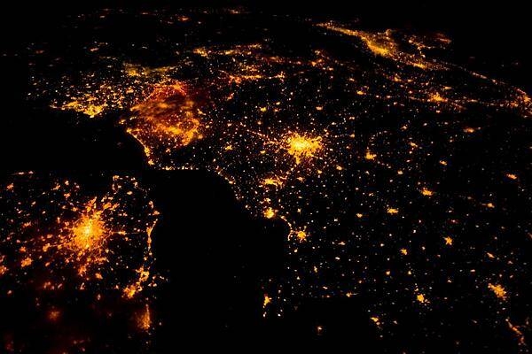
Several of the oldest cities of northwestern Europe are highlighted in this astronaut photo of 10 August 2011. While the landscape is dotted with clusters of lights from individual urban areas, the metropolitan areas of London (lower left), Paris (center), Brussels, and Amsterdam (upper left) stand out due to their large light "footprints." The metropolitan area of Milan is also visible at image upper right. While each of these cities is, or has been, the capital of a kingdom, republic, or empire - Paris and London have been all three - Brussels is also the capital city of the European Union. To give a sense of scale, the centers of the London and Paris metropolitan areas are approximately 340 km (210 mi) from each other. The image is also oblique making the distance between Paris and Milan (640 km, or 400 mi) appear less than that of Paris to London. In contrast to the land surface defined by the city lights, the English Channel presents a uniform dark appearance. Similarly, the Alps near Milan are also largely devoid of lights. While much of the atmosphere was clear at the time the image was taken, the lights of Brussels are dimmed by thin cloud cover. Image courtesy of NASA.
Several of the oldest cities of northwestern Europe are highlighted in this astronaut photo of 10 August 2011. While the landscape is dotted with clusters of lights from individual urban areas, the metropolitan areas of London (lower left), Paris (center), Brussels, and Amsterdam (upper left) stand out due to their large light "footprints." The metropolitan area of Milan is also visible at image upper right. While each of these cities is, or has been, the capital of a kingdom, republic, or empire - Paris and London have been all three - Brussels is also the capital city of the European Union. To give a sense of scale, the centers of the London and Paris metropolitan areas are approximately 340 km (210 mi) from each other. The image is also oblique making the distance between Paris and Milan (640 km, or 400 mi) appear less than that of Paris to London. In contrast to the land surface defined by the city lights, the English Channel presents a uniform dark appearance. Similarly, the Alps near Milan are also largely devoid of lights. While much of the atmosphere was clear at the time the image was taken, the lights of Brussels are dimmed by thin cloud cover. Image courtesy of NASA. • CIA World Factbook • 2020
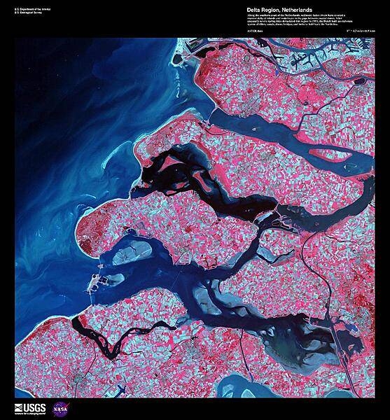
Along the southern coast of the Netherlands, sediment-laden rivers have created a massive delta of islands and waterways in the gaps between coastal dunes. The area in this false-color satellite image is extensively farmed, giving the photo its patchwork look. The Dutch have built an elaborate system of dikes, canals, dams, bridges, and locks to hold back the North Sea because of rising sea levels and devastating historic floods. The Dutch coastline has changed significantly over time due to these floods, such as the 1134 storm that formed the Zeeland archipelago when water covered massive swaths of land. Other major floods include St. Lucia's Day flood in 1287, St. Elizabeth's Day flood in 1421, and a massive flood in 1953 that sparked the building of the Delta works system in place today. The Delta works will be under stress in coming years as sea levels continue to rise. Image courtesy of USGS.
Along the southern coast of the Netherlands, sediment-laden rivers have created a massive delta of islands and waterways in the gaps between coastal dunes. The area in this false-color satellite image is extensively farmed, giving the photo its patchwork look. The Dutch have built an elaborate system of dikes, canals, dams, bridges, and locks to hold back the North Sea because of rising sea levels and devastating historic floods. The Dutch coastline has changed significantly over time due to these floods, such as the 1134 storm that formed the Zeeland archipelago when water covered massive swaths of land. Other major floods include St. Lucia's Day flood in 1287, St. Elizabeth's Day flood in 1421, and a massive flood in 1953 that sparked the building of the Delta works system in place today. The Delta works will be under stress in coming years as sea levels continue to rise. Image courtesy of USGS. • CIA World Factbook • 2020
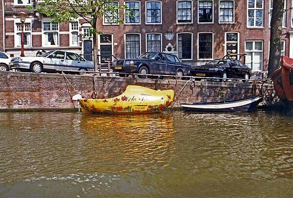
A wooden shoe-shaped boat on an Amsterdam canal. Most of the city's canals were built in the 17th century. The old city center of Amsterdam is the focal point for architectural styles prior the end of the 19th century; outlying areas display more recent architectural styles.
A wooden shoe-shaped boat on an Amsterdam canal. Most of the city's canals were built in the 17th century. The old city center of Amsterdam is the focal point for architectural styles prior the end of the 19th century; outlying areas display more recent architectural styles. • CIA World Factbook • 2020
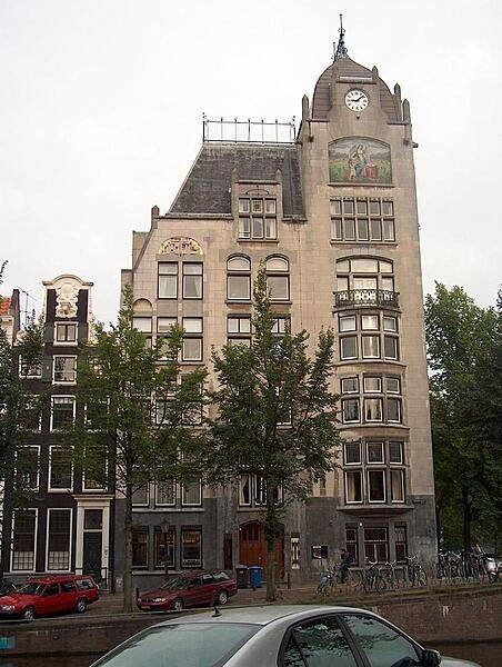
The Astoria building in Amsterdam, built 1904-05, is indicative of a more reserved style of Art-Nouveau (Jugendstil) that came to be known as "New Art" (Nieuwe Kunst). Though difficult to distinguish, typical Art-Nouveau engravings appear in the gray stone around the doorway.
The Astoria building in Amsterdam, built 1904-05, is indicative of a more reserved style of Art-Nouveau (Jugendstil) that came to be known as "New Art" (Nieuwe Kunst). Though difficult to distinguish, typical Art-Nouveau engravings appear in the gray stone around the doorway. • CIA World Factbook • 2020
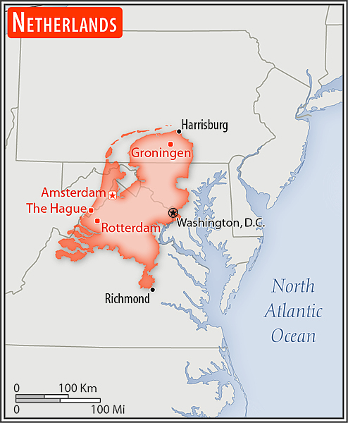
Area comparison map
Area comparison map • CIA World Factbook • 2020
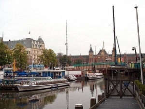
The Amsterdam Centraal railway station overlooks the city's harbor.
The Amsterdam Centraal railway station overlooks the city's harbor. • CIA World Factbook • 2020
19 photos available
View All Photos→Data sources: World Bank, UN Data • Updated daily •Learn about our data