›››
Norway
Norway
Population
5.6M
Rank #118Source: World Bank
Capital
Oslo
Source: REST Countries
Region
Europe
Europe & Central Asia
Source: REST Countries
GDP (Nominal)
$483.59B
Rank #31Source: World Bank
Land Area
386.2K km²
Rank #62Source: REST Countries
Life Expectancy
83.112 yrs
Source: World Bank
Historical Trends
Population Trend (5-Year)
Source: World Bank
GDP Trend (5-Year, Nominal USD)
Source: World Bank
Geography
Area: 386,224 km²
Landlocked: No
Independent: Yes
Climate: temperate along coast, modified by North Atlantic Current; colder interior with increased precipitation and colder summers; rainy year-round on west coast
Terrain: glaciated; mostly high plateaus and rugged mountains broken by fertile valleys; small, scattered plains; coastline deeply indented by fjords; arctic tundra in north
Elevation: mean elevation: 460 m lowest point: Norwegian Sea 0 m highest point: Galdhopiggen 2,469 m
Natural Hazards: rockslides, avalanchesvolcanism: Beerenberg (2,227 m) on Jan Mayen Island in the Norwegian Sea is the country's only active volcano
Environmental Issues: water pollution; acid rain damaging forests and adversely affecting lakes, threatening fish stocks; air pollution from vehicle emissions
Land Use: agricultural land: 2.7% (2011 est.) forest: 27.8% (2011 est.) other: 69.5% (2011 est.)
Geography Note: about two-thirds mountains; some 50,000 islands off its much-indented coastline; strategic location adjacent to sea lanes and air routes in North Atlantic; one of the most rugged and longest...
Natural Resources
petroleumnatural gasiron orecopperleadzinctitaniumpyritesnickelfish
People & Society
Fertility Rate
1.40
Population
5.6M
Ethnic Groups
Norwegian (83.2%)other European (8.3%)other (8.5%)
Religions
Church of Norway (Evangelical Lutheran - official) (70.6%)Muslim (3.2%)Roman Catholic (3%)other Christian (3.7%)other (2.5%)unspecified (17%)
Economy
GDP per Capita
$86,785.433
GDP per Capita PPP
102,037.527
(2024)
(2024)
GNI per Capita
98,170
(2024)
(2024)
Gini Index
26.5
(2023)
(2023)
Unemployment
4%
(2024)
(2024)
Inflation
3.145%
(2024)
(2024)
Public Debt
Not Available
Energy
Electricity Access
100%
(2023)
(2023)
Renewable Energy
61.4%
(2021)
(2021)
CO₂ Emissions
40 Mt
(2024)
(2024)
Energy Intensity
3.21 MJ/$
(2022)
(2022)
Renewable Electricity
99.104%
(2021)
(2021)
Environment
Forest Coverage
33.501% of land
(2023)
(2023)
Communications
Internet Users
99%
(2023)
(2023)
Mobile Penetration
111.657%
(2022)
(2022)
Broadband Subscribers
45.438%
(2023)
(2023)
Transportation
Air Transport Freight
Not Available
Container Port Traffic
933,300 TEU
(2022)
(2022)
Airports
N/A
Rail Lines
3,885 km
Roads Total
N/A
Military
Military Forces
Norwegian Armed Forces: Norwegian Army (Haeren), Royal Norwegian Navy (Kongelige Norske Sjoeforsvaret; includes Coastal Rangers and Coast Guard (Kystvakt)), Royal Norwegian Air Force (Kongelige...
Personnel Strength
the Norwegian Armed Forces have approximately 23,000 active personnel (8,400 Army; 3,500 Navy; 3,500 Air Force; 600 active Home Guard; 7,000 other, including special operations, cyber, joint staff,...
Military Expenditure (USD)
$10.44B
Military Expenditure (% of GDP)
2.09%
Military Expenditure History
1.8% of GDP (2019 est.) 1.73% of GDP (2018) 1.71% of GDP (2017) 1.73% of GDP (2016) 1.59% of GDP (2015)
Deployments
120 Lithuania (NATO) (2020)
Equipment & Inventories
the Norwegian Armed Forces inventory includes mostly imported European and US weapons systems, as well as a limited mix of domestically-produced equipment, particularly small naval craft; since 2010,...
Service Age & Obligation
19-35 years of age for male and female selective compulsory military service; 17 years of age for male volunteers (16 in wartime); 18 years of age for women; 19-month service obligation; conscripts...
Education
Pre-Primary Enrollment
96.339%
(2020)
(2020)
Primary Enrollment
98.61%
(2023)
(2023)
Secondary Enrollment
117.775%
(2023)
(2023)
Tertiary Enrollment
95.057%
(2023)
(2023)
Education Spending
5.456% of GDP
(2022)
(2022)
Pupil-Teacher Ratio
8.594:1
(2017)
(2017)
Health
Physicians per 1,000
4.975
(2023)
(2023)
Safe Water Access
100%
(2024)
(2024)
Safe Drinking Water
99.062%
(2024)
(2024)
Under-5 Mortality
2.4 per 1,000
(2023)
(2023)
Maternal Mortality (World Bank)
24.834 per 100,000
(2021)
(2021)
Hospital Beds per 1,000
84.253
(2021)
(2021)
UHC Coverage Index
89
(2023)
(2023)
Measles Immunization
97%
(2024)
(2024)
Social Indicators
Extreme Poverty Rate
0.2%
(2023)
(2023)
Food Insecurity
2.5%
(2023)
(2023)
Youth NEET Rate
12.059%
(2024)
(2024)
Governance
Women in Government
44.379%
(2024)
(2024)
Voice & Accountability
1.78
(Strong)
(2023)
(Strong)
(2023)
Political Stability
0.89
(Above Average)
(2023)
(Above Average)
(2023)
Government Effectiveness
1.80
(Strong)
(2023)
(Strong)
(2023)
Regulatory Quality
1.60
(Strong)
(2023)
(Strong)
(2023)
Rule of Law
1.83
(Strong)
(2023)
(Strong)
(2023)
Control of Corruption
2.11
(Strong)
(2023)
(Strong)
(2023)
Government
Government Type
parliamentary constitutional monarchy
Legal System
mixed legal system of civil, common, and customary law; Supreme Court can advise on legislative acts
Executive Branch
chief of state: King HARALD V (since 17 January 1991); Heir Apparent Crown Prince HAAKON MAGNUS (son of the monarch, born 20 July 1973) head of government: Prime Minister Erna SOLBERG (since 16...
Legislative Branch
description: unicameral Parliament or Storting (169 seats; members directly elected in multi-seat constituencies by proportional representation vote; members serve 4-year terms) elections: last held...
Judicial Branch
highest courts: Supreme Court or Hoyesterett (consists of the chief justice and 18 associate justices) judge selection and term of office: justices appointed by the monarch (King in Council) upon the...
International Organizations
National Symbols
Flag Description
red with a blue cross outlined in white that extends to the edges of the flag; the vertical part of the cross is shifted to the hoist side in the style of the Dannebrog (Danish flag); the colors...
National Symbols
lion; national colors: red, white, blue
National Anthem
name: "Ja, vi elsker dette landet" (Yes, We Love This Country) lyrics/music: lyrics/music: Bjornstjerne BJORNSON/Rikard NORDRAAK note: adopted 1864; in addition to the national anthem, "Kongesangen"...
Safety
Homicide Rate
0.725 per 100,000
(2023)
(2023)
Travel Information
Language(s): Norwegian Nynorsk, Norwegian Bokmål, Sami
Currency: NOK (kr)
Timezone(s): UTC+01:00
Landlocked: No
Independent: Yes
Driving Side: Right
Calling Code: +47
Car Sign: N
Week Starts: Monday
Photos
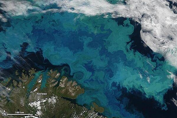
Brilliant shades of blue and green explode across the Barents Sea in this natural-color satellite image taken on 14 August 2011. The color was created by a massive bloom of phytoplankton that is common in the area each August. The clear view is a rare treat since the Barents Sea is cloud-covered roughly 80 percent of the time in summer. Plankton blooms spanning hundreds or even thousands of kilometers occur across the North Atlantic and Arctic Oceans every year. Many species thrive in the cooler ocean waters, which tend to be richer in nutrients and plant life than tropical waters. The area in this image is located immediately north of the Scandinavian peninsula. The region is a junction where several ocean current systems - including the Norwegian Atlantic, the Persey, and east Spitsbergen currents - merge and form a front known as the North Cape Current. The intersecting waters, plus stiff winds, promote mixing of waters and of nutrients from the deep. Image courtesy of NASA.
Brilliant shades of blue and green explode across the Barents Sea in this natural-color satellite image taken on 14 August 2011. The color was created by a massive bloom of phytoplankton that is common in the area each August. The clear view is a rare treat since the Barents Sea is cloud-covered roughly 80 percent of the time in summer. Plankton blooms spanning hundreds or even thousands of kilometers occur across the North Atlantic and Arctic Oceans every year. Many species thrive in the cooler ocean waters, which tend to be richer in nutrients and plant life than tropical waters.
The area in this image is located immediately north of the Scandinavian peninsula. The region is a junction where several ocean current systems - including the Norwegian Atlantic, the Persey, and east Spitsbergen currents - merge and form a front known as the North Cape Current. The intersecting waters, plus stiff winds, promote mixing of waters and of nutrients from the deep. Image courtesy of NASA. • CIA World Factbook • 2020
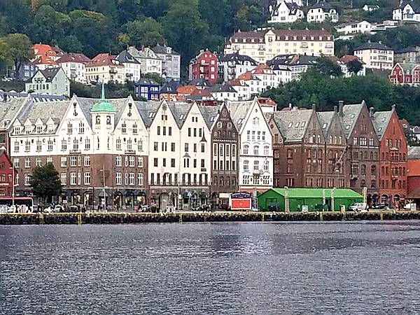
The wharf at Bergen, Norway's second largest city. Bergen served as Norway's capital during the 13th century.
The wharf at Bergen, Norway's second largest city. Bergen served as Norway's capital during the 13th century. • CIA World Factbook • 2020
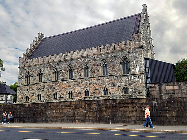
The Berghus Fortress at the Bergen harbor entrance dates from A.D. 1240; it is one of the oldest and best-preserved stone buildings in Norway.
The Berghus Fortress at the Bergen harbor entrance dates from A.D. 1240; it is one of the oldest and best-preserved stone buildings in Norway. • CIA World Factbook • 2020
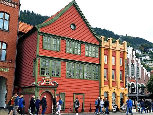
Brightly painted warehouses along the Hanseatic Wharf in Bryggen, the dock area of historic Bergen. Bryggen has been a UNESCO World Cultural Heritage site since 1979.
Brightly painted warehouses along the Hanseatic Wharf in Bryggen, the dock area of historic Bergen. Bryggen has been a UNESCO World Cultural Heritage site since 1979. • CIA World Factbook • 2020
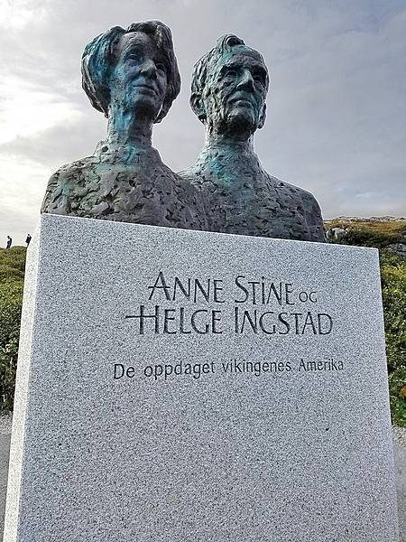
Statue of Anne Stine and Helge Ingstad, the co-discoverers of the archeological site, dedicated by the king of Norway at L’Anse Aux Meadows in 2002.
Statue of Anne Stine and Helge Ingstad, the co-discoverers of the archeological site, dedicated by the king of Norway at L’Anse Aux Meadows in 2002. • CIA World Factbook • 2020
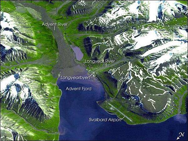
Spitsbergen, the largest of the islands in the Svalbard Archipelago, sits well inside the Arctic Circle, just south of 80 degrees north latitude. This image of the island and its topography was captured by NASA's Terra satellite. The rugged mountains are capped with snow and glaciers, with only the river valleys and low elevations supporting vegetation. Braided, shallow rivers filled with glacial sediment occupy the valleys. The vertical scale is exaggerated by a factor of two to emphasize the rugged terrain. The small town of Longyearbyen serves as the capital; its small airport provides the most northerly public airline service on earth. Although coal mining is still an important economic activity on the frigid island, scientists have recently become as interested in what can be tucked away in the frozen mountains of Spitsbergen as what can be extracted from them. In late February 2008, Norway accepted the first deposit for a so-called "Doomsday" agricultural seed vault, drilled deep into the mountains overlooking the Svalbard Airport. Financed by Norway, the Svalbard Global Seed Vault will safeguard seeds of human food crops from all over the world in the event a natural or human-caused catastrophic event would threaten the human food supply. Photo courtesy of NASA.
Spitsbergen, the largest of the islands in the Svalbard Archipelago, sits well inside the Arctic Circle, just south of 80 degrees north latitude. This image of the island and its topography was captured by NASA's Terra satellite. The rugged mountains are capped with snow and glaciers, with only the river valleys and low elevations supporting vegetation. Braided, shallow rivers filled with glacial sediment occupy the valleys. The vertical scale is exaggerated by a factor of two to emphasize the rugged terrain. The small town of Longyearbyen serves as the capital; its small airport provides the most northerly public airline service on earth. Although coal mining is still an important economic activity on the frigid island, scientists have recently become as interested in what can be tucked away in the frozen mountains of Spitsbergen as what can be extracted from them. In late February 2008, Norway accepted the first deposit for a so-called "Doomsday" agricultural seed vault, drilled deep into the mountains overlooking the Svalbard Airport. Financed by Norway, the Svalbard Global Seed Vault will safeguard seeds of human food crops from all over the world in the event a natural or human-caused catastrophic event would threaten the human food supply. Photo courtesy of NASA. • CIA World Factbook • 2020
22 photos available
View All Photos→Data sources: World Bank, UN Data • Updated daily •Learn about our data