›››
Norway — Media Gallery
22 items available (flags, maps, photos)
Photos
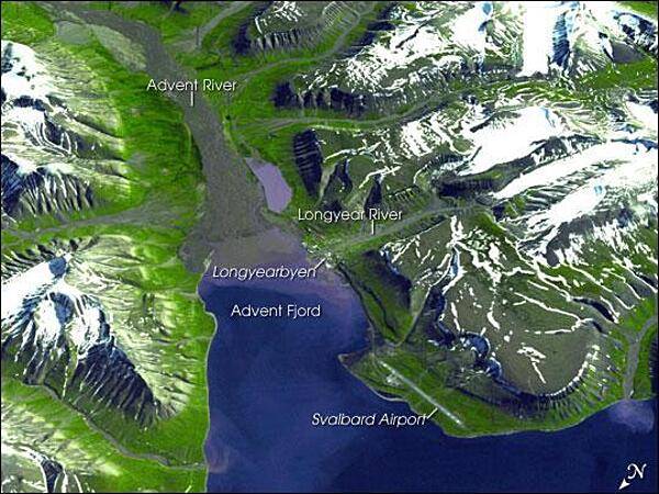
Spitsbergen, the largest of the islands in the Svalbard Archipelago, sits well inside the Arctic Circle, just south of 80 degrees north latitude. This image of the island and its topography was captured by NASA's Terra satellite. The rugged mountains are capped with snow and glaciers, with only the river valleys and low elevations supporting vegetation. Braided, shallow rivers filled with glacial sediment occupy the valleys. The vertical scale is exaggerated by a factor of two to emphasize the rugged terrain. The small town of Longyearbyen serves as the capital; its small airport provides the most northerly public airline service on earth. Although coal mining is still an important economic activity on the frigid island, scientists have recently become as interested in what can be tucked away in the frozen mountains of Spitsbergen as what can be extracted from them. In late February 2008, Norway accepted the first deposit for a so-called "Doomsday" agricultural seed vault, drilled deep into the mountains overlooking the Svalbard Airport. Financed by Norway, the Svalbard Global Seed Vault will safeguard seeds of human food crops from all over the world in the event a natural or human-caused catastrophic event would threaten the human food supply. Photo courtesy of NASA.
Spitsbergen, the largest of the islands in the Svalbard Archipelago, sits well inside the Arctic Circle, just south of 80 degrees north latitude. This image of the island and its topography was captured by NASA's Terra satellite. The rugged mountains are capped with snow and glaciers, with only the river valleys and low elevations supporting vegetation. Braided, shallow rivers filled with glacial sediment occupy the valleys. The vertical scale is exaggerated by a factor of two to emphasize the rugged terrain. The small town of Longyearbyen serves as the capital; its small airport provides the most northerly public airline service on earth. Although coal mining is still an important economic activity on the frigid island, scientists have recently become as interested in what can be tucked away in the frozen mountains of Spitsbergen as what can be extracted from them. In late February 2008, Norway accepted the first deposit for a so-called "Doomsday" agricultural seed vault, drilled deep into the mountains overlooking the Svalbard Airport. Financed by Norway, the Svalbard Global Seed Vault will safeguard seeds of human food crops from all over the world in the event a natural or human-caused catastrophic event would threaten the human food supply. Photo courtesy of NASA. • CIA World Factbook • 2020
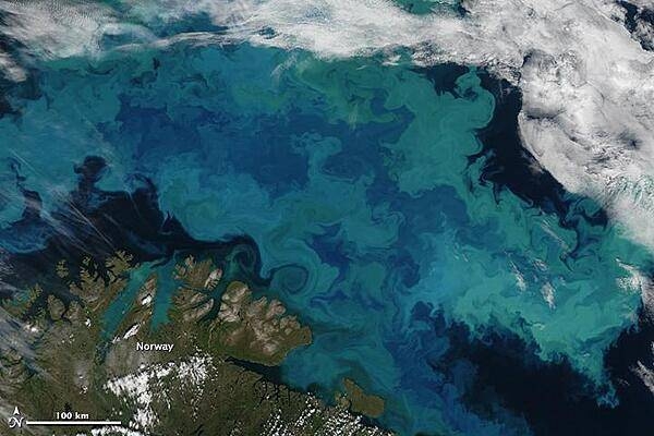
Brilliant shades of blue and green explode across the Barents Sea in this natural-color satellite image taken on 14 August 2011. The color was created by a massive bloom of phytoplankton that is common in the area each August. The clear view is a rare treat since the Barents Sea is cloud-covered roughly 80 percent of the time in summer. Plankton blooms spanning hundreds or even thousands of kilometers occur across the North Atlantic and Arctic Oceans every year. Many species thrive in the cooler ocean waters, which tend to be richer in nutrients and plant life than tropical waters. The area in this image is located immediately north of the Scandinavian peninsula. The region is a junction where several ocean current systems - including the Norwegian Atlantic, the Persey, and east Spitsbergen currents - merge and form a front known as the North Cape Current. The intersecting waters, plus stiff winds, promote mixing of waters and of nutrients from the deep. Image courtesy of NASA.
Brilliant shades of blue and green explode across the Barents Sea in this natural-color satellite image taken on 14 August 2011. The color was created by a massive bloom of phytoplankton that is common in the area each August. The clear view is a rare treat since the Barents Sea is cloud-covered roughly 80 percent of the time in summer. Plankton blooms spanning hundreds or even thousands of kilometers occur across the North Atlantic and Arctic Oceans every year. Many species thrive in the cooler ocean waters, which tend to be richer in nutrients and plant life than tropical waters.
The area in this image is located immediately north of the Scandinavian peninsula. The region is a junction where several ocean current systems - including the Norwegian Atlantic, the Persey, and east Spitsbergen currents - merge and form a front known as the North Cape Current. The intersecting waters, plus stiff winds, promote mixing of waters and of nutrients from the deep. Image courtesy of NASA. • CIA World Factbook • 2020
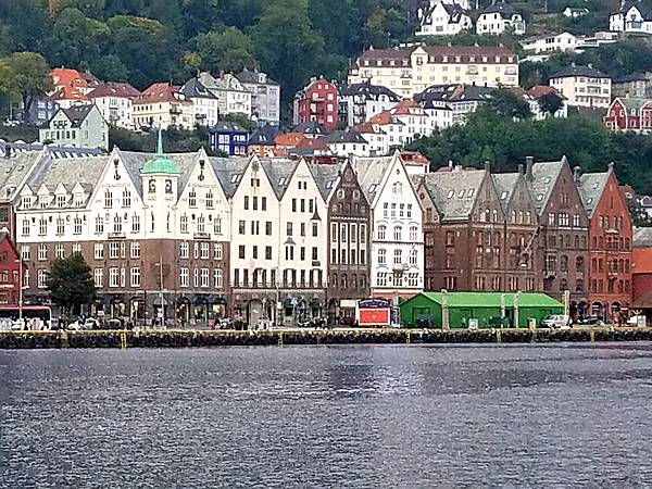
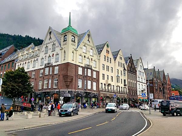
The wharf at Bergen, Norway's second largest city. Bergen served as Norway's capital during the 13th century.
The wharf at Bergen, Norway's second largest city. Bergen served as Norway's capital during the 13th century. • CIA World Factbook • 2020
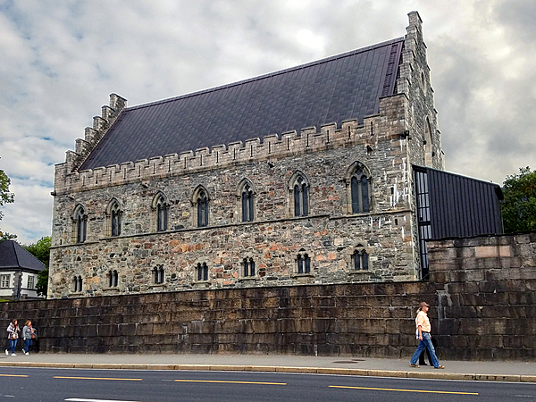
The Berghus Fortress at the Bergen harbor entrance dates from A.D. 1240; it is one of the oldest and best-preserved stone buildings in Norway.
The Berghus Fortress at the Bergen harbor entrance dates from A.D. 1240; it is one of the oldest and best-preserved stone buildings in Norway. • CIA World Factbook • 2020
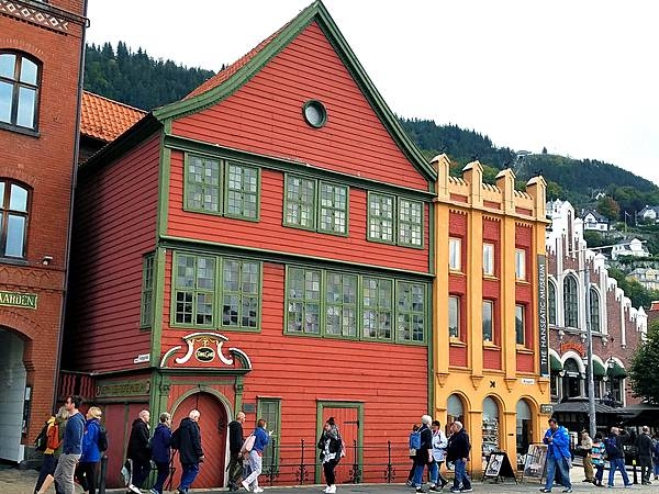
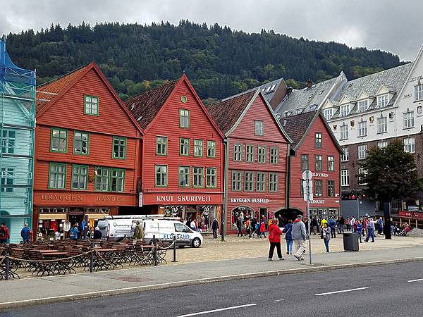
Brightly painted warehouses along the Hanseatic Wharf in Bryggen, the dock area of historic Bergen. Bryggen has been a UNESCO World Cultural Heritage site since 1979.
Brightly painted warehouses along the Hanseatic Wharf in Bryggen, the dock area of historic Bergen. Bryggen has been a UNESCO World Cultural Heritage site since 1979. • CIA World Factbook • 2020
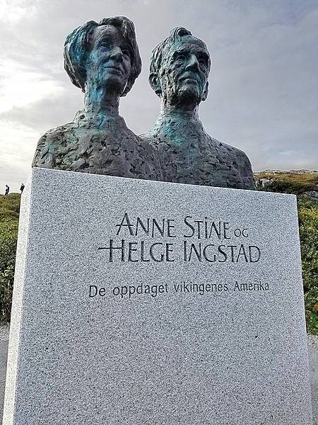
Statue of Anne Stine and Helge Ingstad, the co-discoverers of the archeological site, dedicated by the king of Norway at L’Anse Aux Meadows in 2002.
Statue of Anne Stine and Helge Ingstad, the co-discoverers of the archeological site, dedicated by the king of Norway at L’Anse Aux Meadows in 2002. • CIA World Factbook • 2020
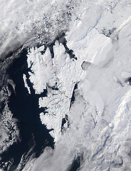
Satellite image shows the island of Svalbard, which is part of Norway, and is located east of Greenland and north of Norway. Photo courtesy of NASA.
Satellite image shows the island of Svalbard, which is part of Norway, and is located east of Greenland and north of Norway. Photo courtesy of NASA. • CIA World Factbook • 2020
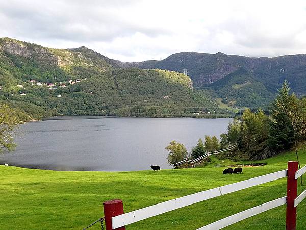
Countryside outside Bergen.
Countryside outside Bergen. • CIA World Factbook • 2020
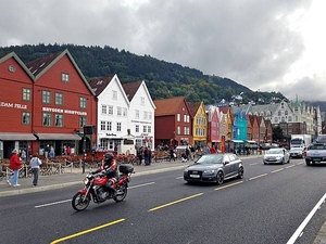
Larger warehouses were built along the Hanseatic Wharf in Bergen after periodic fires destroyed the original buildings.
Larger warehouses were built along the Hanseatic Wharf in Bergen after periodic fires destroyed the original buildings. • CIA World Factbook • 2020
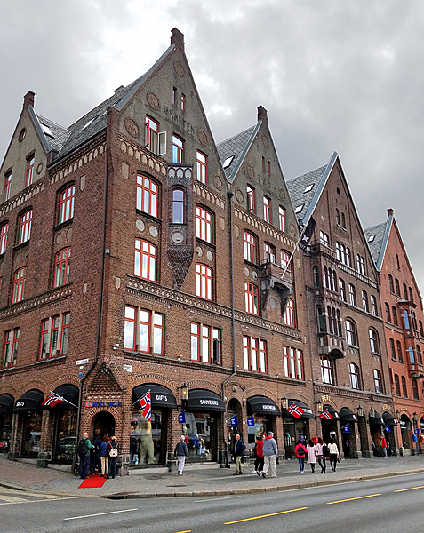
Reconstructed warehouses on the Bergen Hanseatic Wharf. Bergen was one of the major foreign trading posts in the Hanseatic League.
Reconstructed warehouses on the Bergen Hanseatic Wharf. Bergen was one of the major foreign trading posts in the Hanseatic League. • CIA World Factbook • 2020
Reconstructed warehouses on the Bergen Hanseatic Wharf. Bergen was one of the major foreign trading posts in the Hanseatic League.
Reconstructed warehouses on the Bergen Hanseatic Wharf. Bergen was one of the major foreign trading posts in the Hanseatic League. • CIA World Factbook • 2020
Larger warehouses were built along the Hanseatic Wharf in Bergen after periodic fires destroyed the original buildings.
Larger warehouses were built along the Hanseatic Wharf in Bergen after periodic fires destroyed the original buildings. • CIA World Factbook • 2020
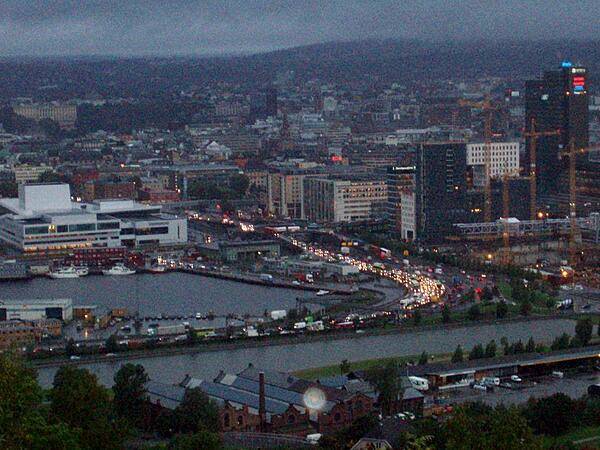
A view of the city of Oslo at dusk.
A view of the city of Oslo at dusk. • CIA World Factbook • 2020
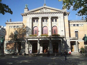
The National Theater in Oslo, opened in 1899.
The National Theater in Oslo, opened in 1899. • CIA World Factbook • 2020
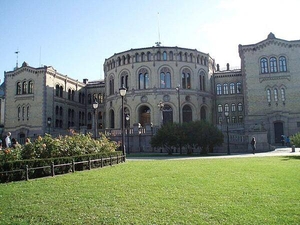
The Parliament Building (Stortinget) in Oslo, constructed between 1861 and 1866.
The Parliament Building (Stortinget) in Oslo, constructed between 1861 and 1866. • CIA World Factbook • 2020
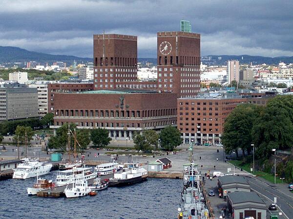
The City Hall (Radhus) in Oslo. Although construction began in 1931, completion was delayed because of World War II. The building was finally inaugurated in 1950. The Nobel Peace Prize ceremony takes place in the City Hall every year on 10 December.
The City Hall (Radhus) in Oslo. Although construction began in 1931, completion was delayed because of World War II. The building was finally inaugurated in 1950. The Nobel Peace Prize ceremony takes place in the City Hall every year on 10 December. • CIA World Factbook • 2020
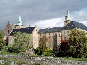
Akershus Fortress is is a medieval castle built to protect the city of Oslo; construction dates back to the late 1290s.
Akershus Fortress is is a medieval castle built to protect the city of Oslo; construction dates back to the late 1290s. • CIA World Factbook • 2020
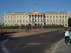
The Royal Palace (Slottet) in Oslo, constructed between 1825 and 1849.
The Royal Palace (Slottet) in Oslo, constructed between 1825 and 1849. • CIA World Factbook • 2020
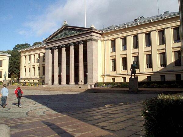
Constructed between 1839 and 1854, what was the former National University in Oslo is today the Law School.
Constructed between 1839 and 1854, what was the former National University in Oslo is today the Law School. • CIA World Factbook • 2020
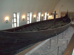
The Gogstad Ship, excavated in 1880, dates to the late 9th century; it is housed in the Viking Ship Museum in Oslo. Constructed largely of oak, the vessel is the largest preserved Viking ship in Norway (24 m long and 5 m wide) and was built to carry 32 oarsmen. The Vikings were able to terrorize much of Europe because of their state-of-the-art ships, which had a shallow draft hull and were able to navigate rivers only one meter deep. Additionally, they were relatively light and could be portaged (carried by the crew) between rivers.
The Gogstad Ship, excavated in 1880, dates to the late 9th century; it is housed in the Viking Ship Museum in Oslo. Constructed largely of oak, the vessel is the largest preserved Viking ship in Norway (24 m long and 5 m wide) and was built to carry 32 oarsmen. The Vikings were able to terrorize much of Europe because of their state-of-the-art ships, which had a shallow draft hull and were able to navigate rivers only one meter deep. Additionally, they were relatively light and could be portaged (carried by the crew) between rivers. • CIA World Factbook • 2020
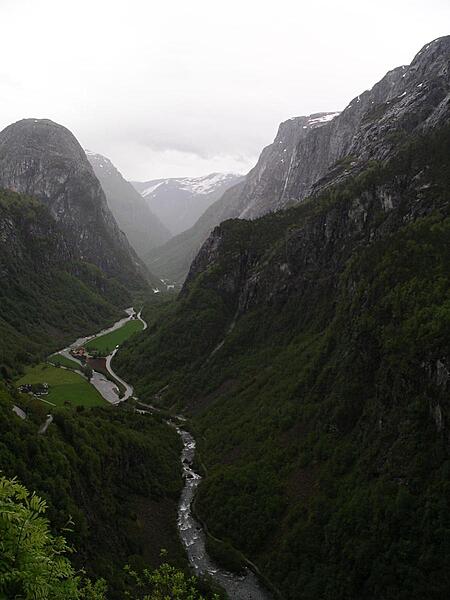
Majestic Naeroy Fjord.
Majestic Naeroy Fjord. • CIA World Factbook • 2020
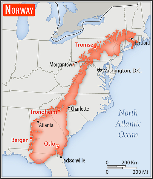
Area comparison map
Area comparison map • CIA World Factbook • 2020
Media source: CIA World Factbook (2020) — Public Domain