›››
New Zealand
New Zealand
Population
5.3M
Rank #123Source: World Bank
Capital
Wellington
Source: REST Countries
Region
Oceania
East Asia & Pacific
Source: REST Countries
GDP (Nominal)
$260.17B
Rank #52Source: World Bank
Land Area
268.8K km²
Rank #76Source: REST Countries
Life Expectancy
83.005 yrs
Source: World Bank
Historical Trends
Population Trend (5-Year)
Source: World Bank
GDP Trend (5-Year, Nominal USD)
Source: World Bank
Geography
Area: 268,838 km²
Landlocked: No
Independent: Yes
Climate: temperate with sharp regional contrasts
Terrain: predominately mountainous with large coastal plains
Elevation: mean elevation: 388 m lowest point: Pacific Ocean 0 m highest point: Aoraki/Mount Cook 3,724 m; note - the mountain's height was 3,764 m until 14 December 1991 when it lost about 10 m in an avalanche...
Natural Hazards: earthquakes are common, though usually not severe; volcanic activityvolcanism: significant volcanism on North Island; Ruapehu (2,797 m), which last erupted in 2007, has a history of large eruptions...
Environmental Issues: water quality and availability; rapid urbanisation; deforestation; soil erosion and degradation; native flora and fauna hard-hit by invasive species; negative effects of climate change
Land Use: agricultural land: 43.2% (2011 est.) forest: 31.4% (2011 est.) other: 25.4% (2011 est.)
Geography Note: note 1: consists of two main islands and a number of smaller islands; South Island, the larger main island, is the 12th largest island in the world and is divided along its length by the Southern...
Natural Resources
natural gasiron oresandcoaltimberhydropowergoldlimestone
People & Society
Fertility Rate
1.56
Population
5.3M
Ethnic Groups
European (64.1%)Maori (16.5%)Chinese (4.9%)Indian (4.7%)Samoan (3.9%)Tongan (1.8%)Cook Islands Maori (1.7%)English (1.5%)Filipino (1.5%)New Zealander (1%)other 13.7%
note: based on the 2018 census of the usually resident population; percentages add up to more than (100%)
Religions
Christian 37.3% (Catholic (10.1%)Anglican (6.8%)Presbyterian and Congregational (5.2%)Pentecostal (1.8%)Methodist (1.6%)Mormon (1.2%)other (10.7%)Hindu (2.7%)Maori (1.3%)Buddhist (1.1%)other religion (1.6%)no religion (48.6%)objected to answering 6.7%
note: based on the 2018 census of the usually resident population; percentages add up to more than (100%)
Economy
GDP per Capita
$49,205.179
GDP per Capita PPP
55,551.144
(2024)
(2024)
GNI per Capita
47,580
(2024)
(2024)
Gini Index
Not Available
Unemployment
4.724%
(2024)
(2024)
Inflation
2.923%
(2024)
(2024)
Public Debt
54.053%
(2023)
(2023)
Energy
Electricity Access
100%
(2023)
(2023)
Renewable Energy
28.9%
(2021)
(2021)
CO₂ Emissions
31.815 Mt
(2024)
(2024)
Energy Intensity
3.52 MJ/$
(2022)
(2022)
Renewable Electricity
81.435%
(2021)
(2021)
Environment
Forest Coverage
37.789% of land
(2023)
(2023)
Communications
Internet Users
96.164%
(2023)
(2023)
Mobile Penetration
126.855%
(2023)
(2023)
Broadband Subscribers
37.853%
(2023)
(2023)
Transportation
Air Transport Freight
767.758 M ton-km
(2023)
(2023)
Container Port Traffic
3,426,030 TEU
(2022)
(2022)
Airports
178,456.983
Rail Lines
N/A
Roads Total
N/A
Military
Military Forces
New Zealand Defence Force (NZDF): New Zealand Army, Royal New Zealand Navy, Royal New Zealand Air Force
Personnel Strength
the New Zealand Defense Force (NZDF) has about 9,600 active duty troops (4,700 Army; 2,300 Navy; 2,600 Air Force)
Military Expenditure (USD)
$3.00B
Military Expenditure (% of GDP)
1.19%
Military Expenditure History
1.5% of GDP (2019) 1.3% of GDP (2018) 1.2% of GDP (2017) 1.2% of GDP (2016) 1.2% of GDP (2015)
Deployments
up to 220 Antarctica (summer season only) (2020)
Equipment & Inventories
NZDF is equipped mostly with imported weapons and equipment from Western suppliers; Australia, France, and the US are the leading suppliers since 2010 (2019 est.)
Service Age & Obligation
17 years of age for voluntary military service; soldiers cannot be deployed until the age of 18; no conscription
Education
Pre-Primary Enrollment
91.681%
(2020)
(2020)
Primary Enrollment
96.867%
(2023)
(2023)
Secondary Enrollment
113.396%
(2023)
(2023)
Tertiary Enrollment
76.381%
(2023)
(2023)
Education Spending
5.276% of GDP
(2023)
(2023)
Pupil-Teacher Ratio
14.916:1
(2017)
(2017)
Health
Physicians per 1,000
3.611
(2022)
(2022)
Safe Water Access
100%
(2024)
(2024)
Safe Drinking Water
100%
(2024)
(2024)
Under-5 Mortality
4.7 per 1,000
(2023)
(2023)
Maternal Mortality (World Bank)
23.777 per 100,000
(2021)
(2021)
Hospital Beds per 1,000
82.201
(2021)
(2021)
UHC Coverage Index
89
(2023)
(2023)
Measles Immunization
89%
(2024)
(2024)
Social Indicators
Extreme Poverty Rate
Not Available
Food Insecurity
2.5%
(2023)
(2023)
Youth NEET Rate
14.142%
(2024)
(2024)
Governance
Women in Government
45.528%
(2024)
(2024)
Voice & Accountability
1.69
(Strong)
(2023)
(Strong)
(2023)
Political Stability
1.36
(Strong)
(2023)
(Strong)
(2023)
Government Effectiveness
1.53
(Strong)
(2023)
(Strong)
(2023)
Regulatory Quality
1.91
(Strong)
(2023)
(Strong)
(2023)
Rule of Law
1.71
(Strong)
(2023)
(Strong)
(2023)
Control of Corruption
2.08
(Strong)
(2023)
(Strong)
(2023)
Government
Government Type
parliamentary democracy under a constitutional monarchy; a Commonwealth realm
Legal System
common law system, based on English model, with special legislation and land courts for the Maori
Executive Branch
chief of state: Queen ELIZABETH II (since 6 February 1952); represented by Governor-General Dame Patricia Lee REDDY (since 28 September 2016) head of government: Prime Minister Jacinda ARDERN (since...
Legislative Branch
description: unicameral House of Representatives - commonly called Parliament (120 seats for 2020-23 term); 72 members directly elected in 65 single-seat constituencies and 7 Maori constituencies by...
Judicial Branch
highest courts: Supreme Court (consists of 5 justices, including the chief justice); note - the Supreme Court in 2004 replaced the Judicial Committee of the Privy Council (in London) as the final...
International Organizations
National Symbols
Flag Description
blue with the flag of the UK in the upper hoist-side quadrant with four red five-pointed stars edged in white centered in the outer half of the flag; the stars represent the Southern Cross...
National Symbols
Southern Cross constellation (four, five-pointed stars), kiwi (bird), silver fern; national colors: black, white, red (ochre)
National Anthem
name: God Defend New Zealand lyrics/music: Thomas BRACKEN [English], Thomas Henry SMITH [Maori]/John Joseph WOODS note: adopted 1940 as national song, adopted 1977 as co-national anthem; New Zealand...
Safety
Homicide Rate
1.461 per 100,000
(2022)
(2022)
Travel Information
Language(s): English, Māori, New Zealand Sign Language
Currency: NZD ($)
Timezone(s): UTC +12:00 to -11:00
Landlocked: No
Independent: Yes
Driving Side: Left
Calling Code: +64
Car Sign: NZ
Week Starts: Monday
Photos
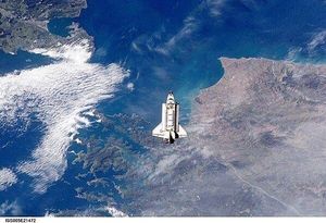
The Space Shuttle Endeavour approaches the International Space Station during rendezvous and docking operations. The spacecraft floats over Cook Strait, the body of water separating New Zealand's North Island (on the left) from South Island (to the right). Click on photo to increase resolution. Image courtesy of NASA.
The Space Shuttle Endeavour approaches the International Space Station during rendezvous and docking operations. The spacecraft floats over Cook Strait, the body of water separating New Zealand's North Island (on the left) from South Island (to the right). Click on photo to increase resolution. Image courtesy of NASA. • CIA World Factbook • 2020
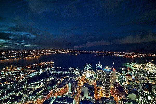
The city of Auckland, the largest in New Zealand, is home to almost a third of the country's population. This is a view of the North Island city at night as seen from its tallest tower.
The city of Auckland, the largest in New Zealand, is home to almost a third of the country's population. This is a view of the North Island city at night as seen from its tallest tower. • CIA World Factbook • 2020
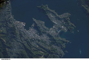
A view of New Zealand's capital of Wellington, located at the southwestern tip of North Island near the Cook Strait. The city is the second largest in New Zealand (after Auckland), and at 41 degrees south latitude, it is the southernmost capital city in the world. Five major geologic faults run through the Wellington municipality. Recognition of the potential seismic hazard in the metropolitan area has led to the adoption of building codes to maximize structural resistance to earthquake damage. Click on photo to increase resolution. Image courtesy of NASA.
A view of New Zealand's capital of Wellington, located at the southwestern tip of North Island near the Cook Strait. The city is the second largest in New Zealand (after Auckland), and at 41 degrees south latitude, it is the southernmost capital city in the world. Five major geologic faults run through the Wellington municipality. Recognition of the potential seismic hazard in the metropolitan area has led to the adoption of building codes to maximize structural resistance to earthquake damage. Click on photo to increase resolution. Image courtesy of NASA. • CIA World Factbook • 2020
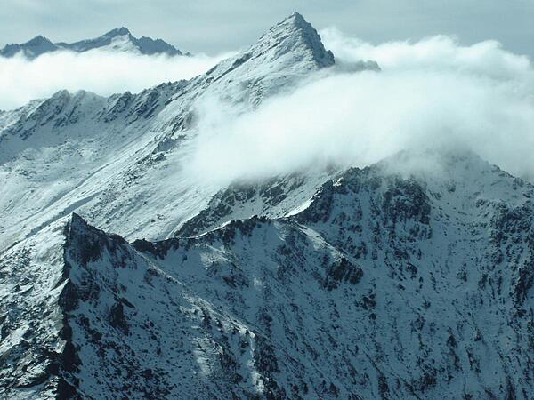
Over the peaks in Fiordland National Park, South Island, the largest of New Zealand's national parks.
Over the peaks in Fiordland National Park, South Island, the largest of New Zealand's national parks. • CIA World Factbook • 2020
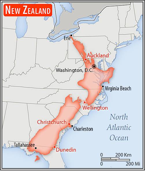
Area comparison map
Area comparison map • CIA World Factbook • 2020
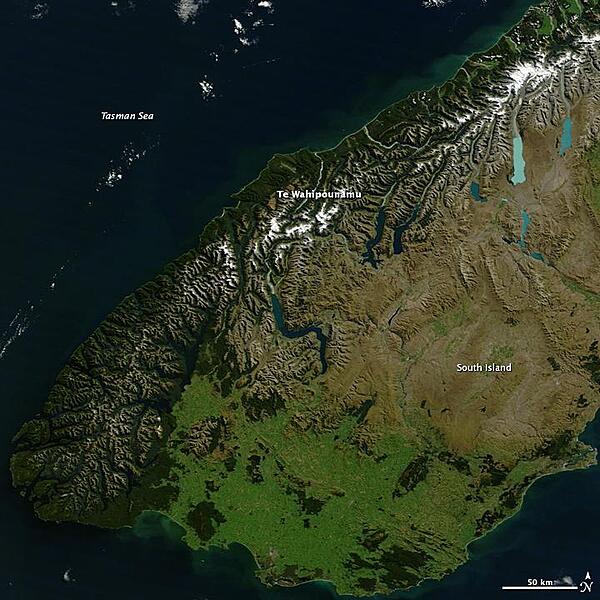
Te Wahipounamu, "the greenstone waters," is a sacred place in the Maori culture of New Zealand. The foreboding mountains and steep-walled valleys on New Zealand's southwest coast are the places of Atua, "the gods." Additionally, the streams that wash down from the glacier-capped peaks carry a highly prized stone, a hard, translucent, green rock that the Maori carved into jewelry and blades, for both tools and weapons. Most New Zealand greenstone is nephrite - a form of jade - though some is bowenite, another mineral. From space, the west coast of New Zealand resembles the greenstone for which it is named. Dark green native forest extends from the mountain tree line to the shore. The forest harbors unique and endangered animals like the kiwi and takahe, both flightless birds, and the kea, the only alpine parrot. The lighter green land in the southeast was once forested, but is now grassland or agriculture. Te Wahipounamu is wilderness, and New Zealand has set the land aside to conserve it. The entire 2.6 million ha (6.4 million acres) that make up the southwest coast of the South Island (about 10 percent of New Zealand's land area) is divided between four national parks, state forests, and other conservation areas. The natural and cultural significance of Te Wahipounamu led UNESCO to declare it a World Heritage area in 1990. Image courtesy of NASA.
Te Wahipounamu, "the greenstone waters," is a sacred place in the Maori culture of New Zealand. The foreboding mountains and steep-walled valleys on New Zealand's southwest coast are the places of Atua, "the gods." Additionally, the streams that wash down from the glacier-capped peaks carry a highly prized stone, a hard, translucent, green rock that the Maori carved into jewelry and blades, for both tools and weapons. Most New Zealand greenstone is nephrite - a form of jade - though some is bowenite, another mineral. From space, the west coast of New Zealand resembles the greenstone for which it is named. Dark green native forest extends from the mountain tree line to the shore. The forest harbors unique and endangered animals like the kiwi and takahe, both flightless birds, and the kea, the only alpine parrot. The lighter green land in the southeast was once forested, but is now grassland or agriculture. Te Wahipounamu is wilderness, and New Zealand has set the land aside to conserve it. The entire 2.6 million ha (6.4 million acres) that make up the southwest coast of the South Island (about 10 percent of New Zealand's land area) is divided between four national parks, state forests, and other conservation areas. The natural and cultural significance of Te Wahipounamu led UNESCO to declare it a World Heritage area in 1990. Image courtesy of NASA. • CIA World Factbook • 2020
35 photos available
View All Photos→Data sources: World Bank, UN Data • Updated daily •Learn about our data