›››
New Zealand — Media Gallery
35 items available (flags, maps, photos)
Photos
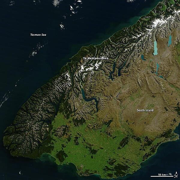
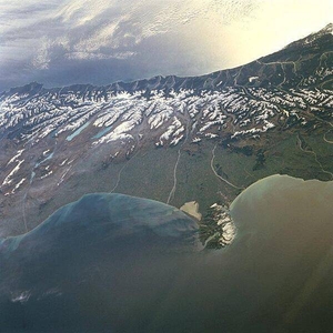
Te Wahipounamu, "the greenstone waters," is a sacred place in the Maori culture of New Zealand. The foreboding mountains and steep-walled valleys on New Zealand's southwest coast are the places of Atua, "the gods." Additionally, the streams that wash down from the glacier-capped peaks carry a highly prized stone, a hard, translucent, green rock that the Maori carved into jewelry and blades, for both tools and weapons. Most New Zealand greenstone is nephrite - a form of jade - though some is bowenite, another mineral. From space, the west coast of New Zealand resembles the greenstone for which it is named. Dark green native forest extends from the mountain tree line to the shore. The forest harbors unique and endangered animals like the kiwi and takahe, both flightless birds, and the kea, the only alpine parrot. The lighter green land in the southeast was once forested, but is now grassland or agriculture. Te Wahipounamu is wilderness, and New Zealand has set the land aside to conserve it. The entire 2.6 million ha (6.4 million acres) that make up the southwest coast of the South Island (about 10 percent of New Zealand's land area) is divided between four national parks, state forests, and other conservation areas. The natural and cultural significance of Te Wahipounamu led UNESCO to declare it a World Heritage area in 1990. Image courtesy of NASA.
Te Wahipounamu, "the greenstone waters," is a sacred place in the Maori culture of New Zealand. The foreboding mountains and steep-walled valleys on New Zealand's southwest coast are the places of Atua, "the gods." Additionally, the streams that wash down from the glacier-capped peaks carry a highly prized stone, a hard, translucent, green rock that the Maori carved into jewelry and blades, for both tools and weapons. Most New Zealand greenstone is nephrite - a form of jade - though some is bowenite, another mineral. From space, the west coast of New Zealand resembles the greenstone for which it is named. Dark green native forest extends from the mountain tree line to the shore. The forest harbors unique and endangered animals like the kiwi and takahe, both flightless birds, and the kea, the only alpine parrot. The lighter green land in the southeast was once forested, but is now grassland or agriculture. Te Wahipounamu is wilderness, and New Zealand has set the land aside to conserve it. The entire 2.6 million ha (6.4 million acres) that make up the southwest coast of the South Island (about 10 percent of New Zealand's land area) is divided between four national parks, state forests, and other conservation areas. The natural and cultural significance of Te Wahipounamu led UNESCO to declare it a World Heritage area in 1990. Image courtesy of NASA. • CIA World Factbook • 2020
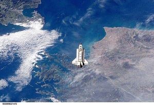
The Space Shuttle Endeavour approaches the International Space Station during rendezvous and docking operations. The spacecraft floats over Cook Strait, the body of water separating New Zealand's North Island (on the left) from South Island (to the right). Click on photo to increase resolution. Image courtesy of NASA.
The Space Shuttle Endeavour approaches the International Space Station during rendezvous and docking operations. The spacecraft floats over Cook Strait, the body of water separating New Zealand's North Island (on the left) from South Island (to the right). Click on photo to increase resolution. Image courtesy of NASA. • CIA World Factbook • 2020
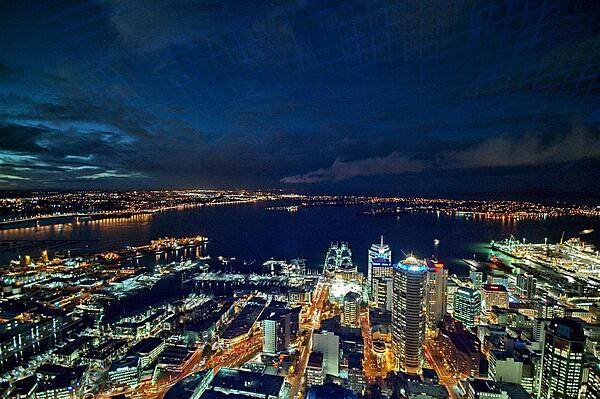
The city of Auckland, the largest in New Zealand, is home to almost a third of the country's population. This is a view of the North Island city at night as seen from its tallest tower.
The city of Auckland, the largest in New Zealand, is home to almost a third of the country's population. This is a view of the North Island city at night as seen from its tallest tower. • CIA World Factbook • 2020
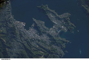
A view of New Zealand's capital of Wellington, located at the southwestern tip of North Island near the Cook Strait. The city is the second largest in New Zealand (after Auckland), and at 41 degrees south latitude, it is the southernmost capital city in the world. Five major geologic faults run through the Wellington municipality. Recognition of the potential seismic hazard in the metropolitan area has led to the adoption of building codes to maximize structural resistance to earthquake damage. Click on photo to increase resolution. Image courtesy of NASA.
A view of New Zealand's capital of Wellington, located at the southwestern tip of North Island near the Cook Strait. The city is the second largest in New Zealand (after Auckland), and at 41 degrees south latitude, it is the southernmost capital city in the world. Five major geologic faults run through the Wellington municipality. Recognition of the potential seismic hazard in the metropolitan area has led to the adoption of building codes to maximize structural resistance to earthquake damage. Click on photo to increase resolution. Image courtesy of NASA. • CIA World Factbook • 2020

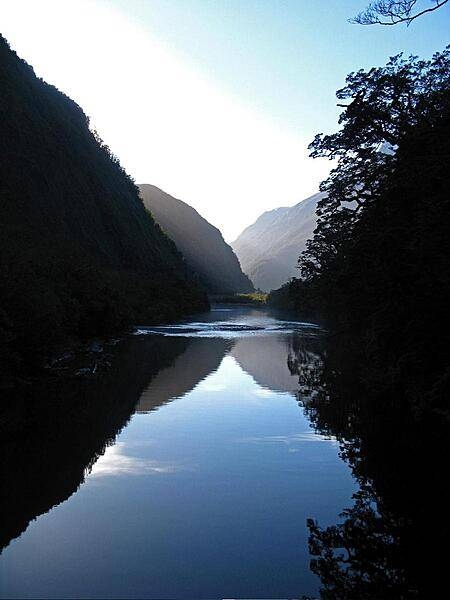
Over the peaks in Fiordland National Park, South Island, the largest of New Zealand's national parks.
Over the peaks in Fiordland National Park, South Island, the largest of New Zealand's national parks. • CIA World Factbook • 2020
Area comparison map
Area comparison map • CIA World Factbook • 2020
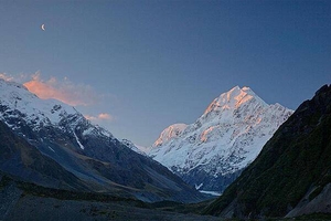
Sunset over Mount Cook (Aoraki) in Mount Cook National Park, South Island.
Sunset over Mount Cook (Aoraki) in Mount Cook National Park, South Island. • CIA World Factbook • 2020
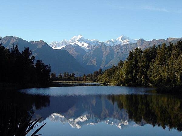
Lake Matheson, on the South Island, is a mirror in the early morning light.
Lake Matheson, on the South Island, is a mirror in the early morning light. • CIA World Factbook • 2020
CIA World Factbook • 2020
CIA World Factbook • 2020
CIA World Factbook • 2020
CIA World Factbook • 2020
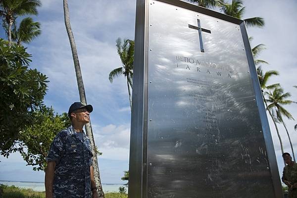
The memorial to 22 New Zealand, British, and Australian coastwatchers on Betio Island, Tarawa atoll, Kiribati. The seventeen New Zealand coastwatchers and five civilians were captured by the Japanese in the Gilbert Islands (now Kiribati) early in World War II and held prisoner on Tarawa, where they were murdered on 15 October 1942. The memorial reads, in part, "Standing unarmed at their posts, they matched brutality with gallantry, and met death with fortitude." Photo courtesy of the US Navy/ Mass Communication Specialist 2nd Class Carlos M. Vazquez II.
The memorial to 22 New Zealand, British, and Australian coastwatchers on Betio Island, Tarawa atoll, Kiribati. The seventeen New Zealand coastwatchers and five civilians were captured by the Japanese in the Gilbert Islands (now Kiribati) early in World War II and held prisoner on Tarawa, where they were murdered on 15 October 1942. The memorial reads, in part, "Standing unarmed at their posts, they matched brutality with gallantry, and met death with fortitude." Photo courtesy of the US Navy/ Mass Communication Specialist 2nd Class Carlos M. Vazquez II. • CIA World Factbook • 2020
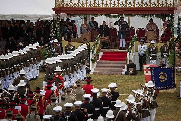
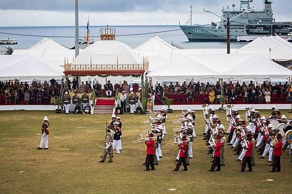
King Tupou VI salutes troops as they pass in review during his coronation celebration in Nuku'alofa, on 6 July 2015. The US Marine Corps Pacific Forces Band performed alongside the Australian Army Band, Tonga's Royal Corps of Musicians, and the New Zealand Army Band in the King's coronation celebration. Photo courtesy of the US Marine Corps/ Cpl. Brittney Vito.
King Tupou VI salutes troops as they pass in review during his coronation celebration in Nuku'alofa, on 6 July 2015. The US Marine Corps Pacific Forces Band performed alongside the Australian Army Band, Tonga's Royal Corps of Musicians, and the New Zealand Army Band in the King's coronation celebration. Photo courtesy of the US Marine Corps/ Cpl. Brittney Vito. • CIA World Factbook • 2020
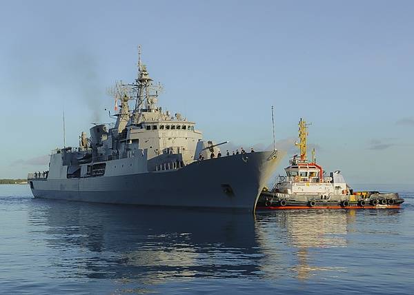
The New Zealand frigate HMNZS Te Mana (F111) makes a port call at Diego Garcia on 23 November 2013. The island's lagoon provides a sheltered anchorage where allied naval vessels can replenish. Diego Garcia provides critical logistical infrastructure support to US and Allied Forces forward deployed to the Indian Ocean and Arabian Gulf. Photo courtesy of US Navy/ Mass Communication Specialist Seaman Alex Smedegard.
The New Zealand frigate HMNZS Te Mana (F111) makes a port call at Diego Garcia on 23 November 2013. The island's lagoon provides a sheltered anchorage where allied naval vessels can replenish. Diego Garcia provides critical logistical infrastructure support to US and Allied Forces forward deployed to the Indian Ocean and Arabian Gulf. Photo courtesy of US Navy/ Mass Communication Specialist Seaman Alex Smedegard. • CIA World Factbook • 2020
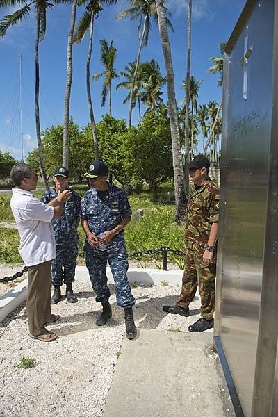
New Zealand High Commissioner of Tarawa Michael Wehi Mailetonga Walsh explains the Betio Memorial to Adm. Cecil D. Haney, commander of the US Pacific Fleet, during his visit to the Republic of Kiribati for Pacific Partnership 2013, 17 July 2013. The memorial is to 22 New Zealand, British, and Australian coastwatchers held prisoner and murdered by Imperial Japanese forces on Betio Island, Tarawa atoll, Kiribati. Photo courtesy of the US Navy/ Mass Communication Specialist 2nd Class Carlos M. Vazquez II.
New Zealand High Commissioner of Tarawa Michael Wehi Mailetonga Walsh explains the Betio Memorial to Adm. Cecil D. Haney, commander of the US Pacific Fleet, during his visit to the Republic of Kiribati for Pacific Partnership 2013, 17 July 2013. The memorial is to 22 New Zealand, British, and Australian coastwatchers held prisoner and murdered by Imperial Japanese forces on Betio Island, Tarawa atoll, Kiribati. Photo courtesy of the US Navy/ Mass Communication Specialist 2nd Class Carlos M. Vazquez II. • CIA World Factbook • 2020
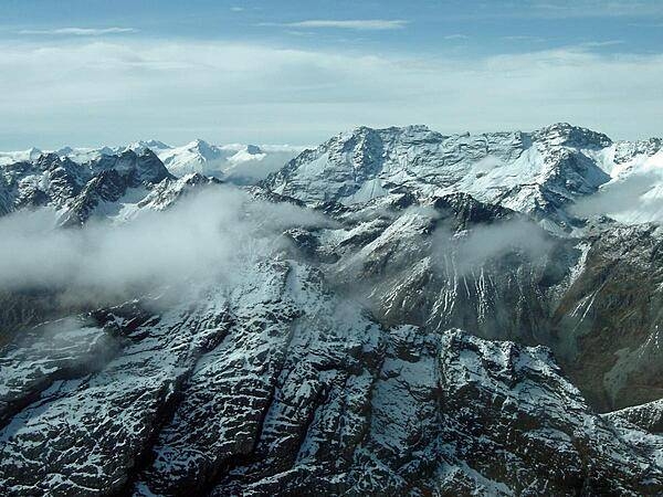
A westward-looking view of central South Island, showing the snow-covered Southern Alps fronted by the Canterbury Plain, the largest area of fertile, flat land in New Zealand. Running southwest to northeast along the western coast of South Island, the Southern Alps are rugged mountains made up of numerous peaks in excess of 3,000 m (9,840 ft). Within the Southern Alps, there are over 3,100 active glaciers. Click on photo to increase resolution. Image courtesy of NASA.
A westward-looking view of central South Island, showing the snow-covered Southern Alps fronted by the Canterbury Plain, the largest area of fertile, flat land in New Zealand. Running southwest to northeast along the western coast of South Island, the Southern Alps are rugged mountains made up of numerous peaks in excess of 3,000 m (9,840 ft). Within the Southern Alps, there are over 3,100 active glaciers. Click on photo to increase resolution. Image courtesy of NASA. • CIA World Factbook • 2020
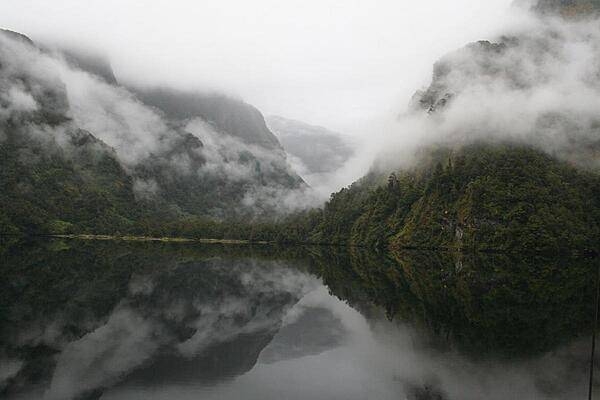
The placid waters and lush foliage of Milford Sound in Fiordland National Park, South Island.
The placid waters and lush foliage of Milford Sound in Fiordland National Park, South Island. • CIA World Factbook • 2020
The US Marine Corps Pacific Forces Band performed for King Tupou VI alongside the Australian Army Band, Tonga's Royal Corps of Musicians, and the New Zealand Army Band during the King's coronation celebration in Nuku’alofa, on 6 July 2015. The US and Tonga have sustained strong partnerships for years that continue to improve through participation in cultural events, such as the King’s coronation. Photo courtesy of the US Marine Corps/ Cpl. Brittney Vito.
The US Marine Corps Pacific Forces Band performed for King Tupou VI alongside the Australian Army Band, Tonga's Royal Corps of Musicians, and the New Zealand Army Band during the King's coronation celebration in Nuku’alofa, on 6 July 2015. The US and Tonga have sustained strong partnerships for years that continue to improve through participation in cultural events, such as the King’s coronation. Photo courtesy of the US Marine Corps/ Cpl. Brittney Vito. • CIA World Factbook • 2020

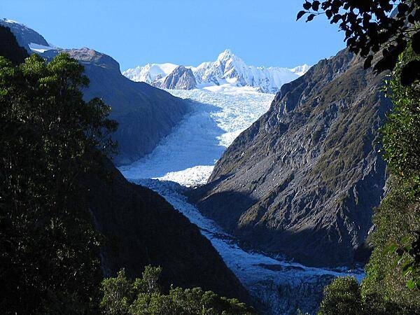
Fox Glacier in Mount Cook National Park, South Island.
Fox Glacier in Mount Cook National Park, South Island. • CIA World Factbook • 2020
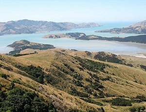
This photo was taken looking southeast on the Banks Peninsula on South Island. The peninsula was formed from eroded remnants of two large composite shield volcanoes, the dominate craters forming the Lyttelton and Akoroa Harbors. The mountainous nature of the peninsula is atypical within the surrounding region.
This photo was taken looking southeast on the Banks Peninsula on South Island. The peninsula was formed from eroded remnants of two large composite shield volcanoes, the dominate craters forming the Lyttelton and Akoroa Harbors. The mountainous nature of the peninsula is atypical within the surrounding region. • CIA World Factbook • 2020
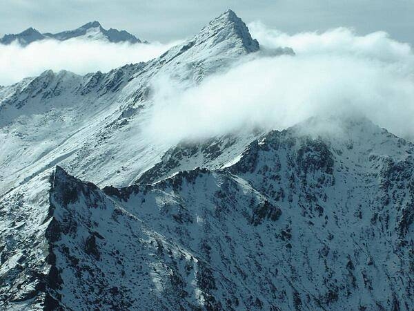
The rugged mountains in Fiordland National Park, South Island.
The rugged mountains in Fiordland National Park, South Island. • CIA World Factbook • 2020
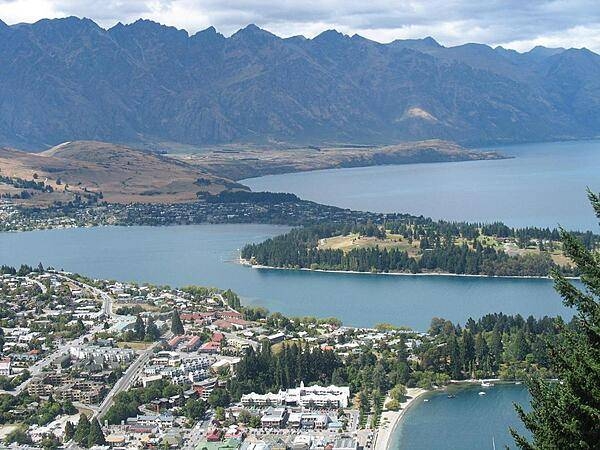
The resort town of Queenstown on South Island is known for its adventure and ski tourism. This photo was taken from one of the hills surrounding the town, looking southeast across the harbor. Queenstown is situated at one of the turns in a Z-shaped mountain lake - Lake Wakatipu - which was formed by glacial processes.
The resort town of Queenstown on South Island is known for its adventure and ski tourism. This photo was taken from one of the hills surrounding the town, looking southeast across the harbor. Queenstown is situated at one of the turns in a Z-shaped mountain lake - Lake Wakatipu - which was formed by glacial processes. • CIA World Factbook • 2020
CIA World Factbook • 2020

A blue-colored lake in South Island.
A blue-colored lake in South Island. • CIA World Factbook • 2020
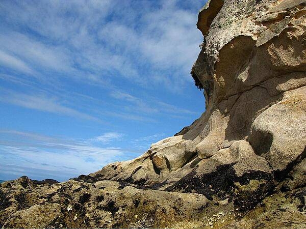
A distinctive rock formation near the town of Motueka - by the Cook Strait - on the South Island.
A distinctive rock formation near the town of Motueka - by the Cook Strait - on the South Island. • CIA World Factbook • 2020
CIA World Factbook • 2020
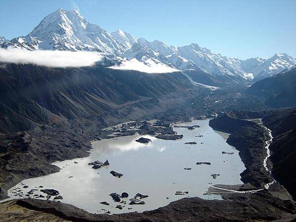
A glacier lake in Fiordland National Park, South Island.
A glacier lake in Fiordland National Park, South Island. • CIA World Factbook • 2020
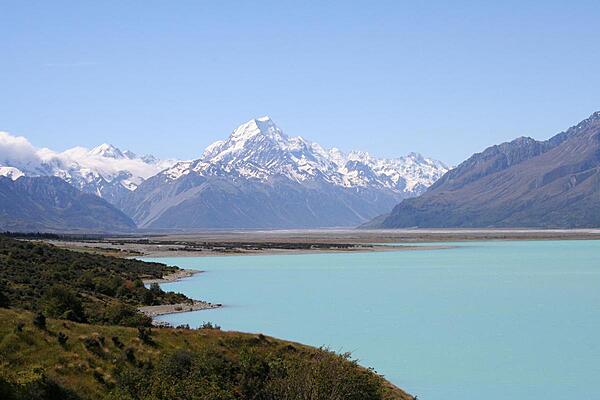
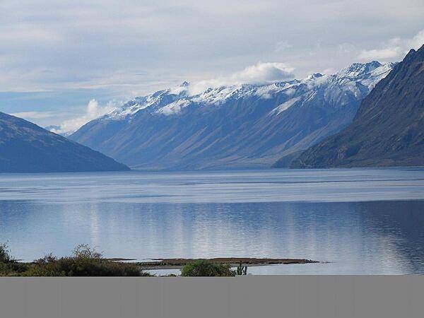
Mount Cook over Lake Pukaki.
Mount Cook over Lake Pukaki. • CIA World Factbook • 2020
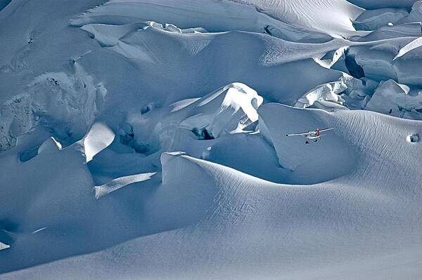
A sightseeing plane over Fox Glacier in Mount Cook National Park, South Island.
A sightseeing plane over Fox Glacier in Mount Cook National Park, South Island. • CIA World Factbook • 2020
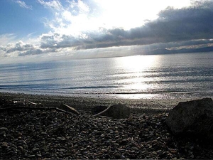
Sunrise over Nelson Bay on the South Island.
Sunrise over Nelson Bay on the South Island. • CIA World Factbook • 2020
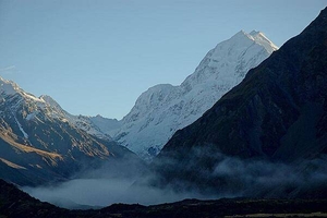
Mount Cook (Aoraki), the tallest mountain in New Zealand, in Mount Cook National Park, South Island.
Mount Cook (Aoraki), the tallest mountain in New Zealand, in Mount Cook National Park, South Island. • CIA World Factbook • 2020

CIA World Factbook • 2020
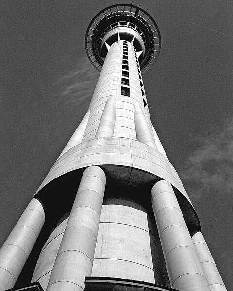
The 328 m (1,076 ft) observation and telecommunications Sky Tower in Auckland is the tallest free-standing structure in the Southern Hemisphere.
The 328 m (1,076 ft) observation and telecommunications Sky Tower in Auckland is the tallest free-standing structure in the Southern Hemisphere. • CIA World Factbook • 2020

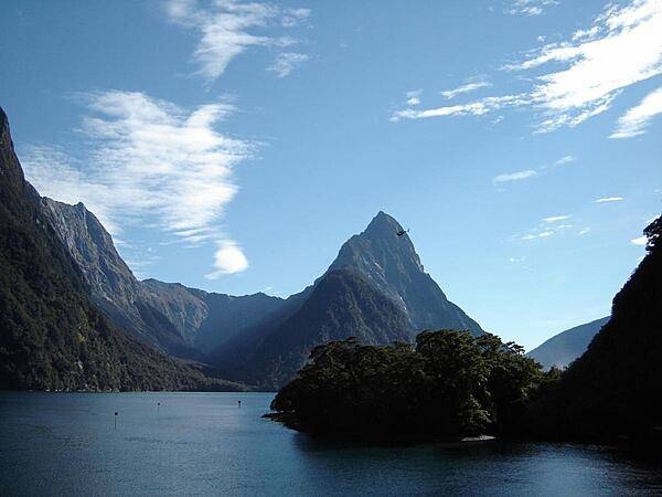
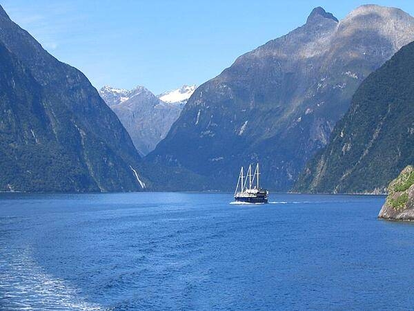
Milford Sound in Fiordland National Park, South Island.
Milford Sound in Fiordland National Park, South Island. • CIA World Factbook • 2020
Media source: CIA World Factbook (2020) — Public Domain