›››
Peru
Peru
Population
34.2M
Rank #48Source: World Bank
Capital
Lima
Source: REST Countries
Region
Americas
Latin America & Caribbean
Source: REST Countries
GDP (Nominal)
$289.22B
Rank #49Source: World Bank
Land Area
1.3M km²
Rank #20Source: REST Countries
Life Expectancy
77.74 yrs
Source: World Bank
Historical Trends
Population Trend (5-Year)
Source: World Bank
GDP Trend (5-Year, Nominal USD)
Source: World Bank
Geography
Area: 1,285,216 km²
Landlocked: No
Independent: Yes
Climate: varies from tropical in east to dry desert in west; temperate to frigid in Andes
Terrain: western coastal plain (costa), high and rugged Andes in center (sierra), eastern lowland jungle of Amazon Basin (selva)
Elevation: mean elevation: 1,555 m lowest point: Pacific Ocean 0 m highest point: Nevado Huascaran 6,746 m
Natural Hazards: earthquakes, tsunamis, flooding, landslides, mild volcanic activityvolcanism: volcanic activity in the Andes Mountains; Ubinas (5,672 m), which last erupted in 2009, is the country's most active...
Environmental Issues: deforestation (some the result of illegal logging); overgrazing of the slopes of the costa and sierra leading to soil erosion; desertification; air pollution in Lima; pollution of rivers and coastal...
Land Use: agricultural land: 18.8% (2011 est.) forest: 53% (2011 est.) other: 28.2% (2011 est.)
Geography Note: note 1: shares control of Lago Titicaca, world's highest navigable lake, with Bolivia; a remote slope of Nevado Mismi, a 5,316 m peak, is the ultimate source of the Amazon River note 2: Peru is one...
Natural Resources
coppersilvergoldpetroleumtimberfishiron orecoalphosphatepotash
People & Society
Fertility Rate
1.98
Population
34.2M
Ethnic Groups
Mestizo (mixed Amerindian and white) (60.2%)Amerindian (25.8%)White (5.9%)African descent (3.6%)other (includes Chinese and Japanese descent) (1.2%)unspecified (3.3%)
Religions
Roman Catholic (60%)Christian 14.6% (includes evangelical (11.1%)other (3.5%)other (0.3%)none (4%)unspecified (21.1%)
Economy
GDP per Capita
$8,452.372
GDP per Capita PPP
17,802.418
(2024)
(2024)
GNI per Capita
7,500
(2024)
(2024)
Gini Index
40.1
(2024)
(2024)
Unemployment
5.199%
(2024)
(2024)
Inflation
2.008%
(2024)
(2024)
Public Debt
35.249%
(2021)
(2021)
Energy
Electricity Access
96.2%
(2023)
(2023)
Renewable Energy
30.6%
(2021)
(2021)
CO₂ Emissions
69.265 Mt
(2024)
(2024)
Energy Intensity
2.3 MJ/$
(2021)
(2021)
Renewable Electricity
61.27%
(2021)
(2021)
Environment
Forest Coverage
56.103% of land
(2023)
(2023)
Communications
Internet Users
81.957%
(2024)
(2024)
Mobile Penetration
121.975%
(2023)
(2023)
Broadband Subscribers
10.436%
(2023)
(2023)
Transportation
Air Transport Freight
299.232 M ton-km
(2023)
(2023)
Container Port Traffic
2,865,239 TEU
(2022)
(2022)
Airports
125,564
Rail Lines
N/A
Roads Total
174,107.8 km(©IRF)
Military
Military Forces
Joint Command of the Armed Forces of Peru: Peruvian Army (Ejercito del Peru), Peruvian Navy (Marina de Guerra del Peru, MGP, includes naval air, naval infantry, and Coast Guard), Air Force of Peru...
Personnel Strength
Peruvian military size estimates vary widely; approximately 95,000 active personnel (55,000 Army; 25,000 Navy; 15,000 Air Force)
Military Expenditure (USD)
$2.57B
Military Expenditure (% of GDP)
0.91%
Military Expenditure History
1.2% of GDP (2019) 1.2% of GDP (2018) 1.2% of GDP (2017) 1.3% of GDP (2016) 1.7% of GDP (2015)
Deployments
200 Central African Republic (MINUSCA) (2020)
Equipment & Inventories
the Peruvian military's inventory is a mix of mostly older equipment from a wide variety of suppliers, including Brazil, Europe, the former Soviet Union, and the US; the leading suppliers of military...
Service Age & Obligation
18-50 years of age for male and 18-45 years of age for female voluntary military service; no conscription
Education
Pre-Primary Enrollment
96.442%
(2021)
(2021)
Primary Enrollment
113.901%
(2023)
(2023)
Secondary Enrollment
111.395%
(2023)
(2023)
Tertiary Enrollment
71.24%
(2017)
(2017)
Education Spending
4.235% of GDP
(2023)
(2023)
Adult Literacy Rate
93.66%
(2024)
(2024)
Pupil-Teacher Ratio
17.387:1
(2018)
(2018)
Health
Physicians per 1,000
1.688
(2023)
(2023)
Safe Water Access
95.637%
(2024)
(2024)
Safe Drinking Water
49.428%
(2024)
(2024)
Under-5 Mortality
15.8 per 1,000
(2023)
(2023)
Maternal Mortality (World Bank)
16.693 per 100,000
(2021)
(2021)
Hospital Beds per 1,000
71.667
(2021)
(2021)
UHC Coverage Index
68
(2023)
(2023)
Measles Immunization
80%
(2024)
(2024)
Social Indicators
Extreme Poverty Rate
5.1%
(2024)
(2024)
Food Insecurity
6.9%
(2023)
(2023)
Youth NEET Rate
8.952%
(2024)
(2024)
Governance
Women in Government
38.462%
(2024)
(2024)
Voice & Accountability
0.06
(Above Average)
(2023)
(Above Average)
(2023)
Political Stability
-0.52
(Below Average)
(2023)
(Below Average)
(2023)
Government Effectiveness
-0.49
(Below Average)
(2023)
(Below Average)
(2023)
Regulatory Quality
0.29
(Above Average)
(2023)
(Above Average)
(2023)
Rule of Law
-0.54
(Below Average)
(2023)
(Below Average)
(2023)
Control of Corruption
-0.72
(Below Average)
(2023)
(Below Average)
(2023)
Government
Government Type
presidential republic
Legal System
civil law system
Executive Branch
chief of state: President Francisco Rafael SAGASTI Hochhausler (since 17 November 2020); First Vice President (vacant); Second Vice President (vacant); note - President Martin Alberto VIZCARRA was...
Legislative Branch
description: unicameral Congress of the Republic of Peru or Congreso de la Republica del Peru (130 seats; members directly elected in multi-seat constituencies by closed party-list proportional...
Judicial Branch
highest courts: Supreme Court (consists of 16 judges and divided into civil, criminal, and constitutional-social sectors) judge selection and term of office: justices proposed by the National Board...
National Symbols
Flag Description
three equal, vertical bands of red (hoist side), white, and red with the coat of arms centered in the white band; the coat of arms features a shield bearing a vicuna (representing fauna), a cinchona...
National Symbols
vicuna (a camelid related to the llama); national colors: red, white
National Anthem
name: "Himno Nacional del Peru" (National Anthem of Peru) lyrics/music: Jose DE LA TORRE Ugarte/Jose Bernardo ALZEDO note: adopted 1822; the song won a national anthem contest
Safety
Homicide Rate
8.605 per 100,000
(2021)
(2021)
Travel Information
Language(s): Aymara, Quechua, Spanish
Currency: PEN (S/ )
Timezone(s): UTC-05:00
Landlocked: No
Independent: Yes
Driving Side: Right
Calling Code: +51
Car Sign: PE
Week Starts: Monday
Photos
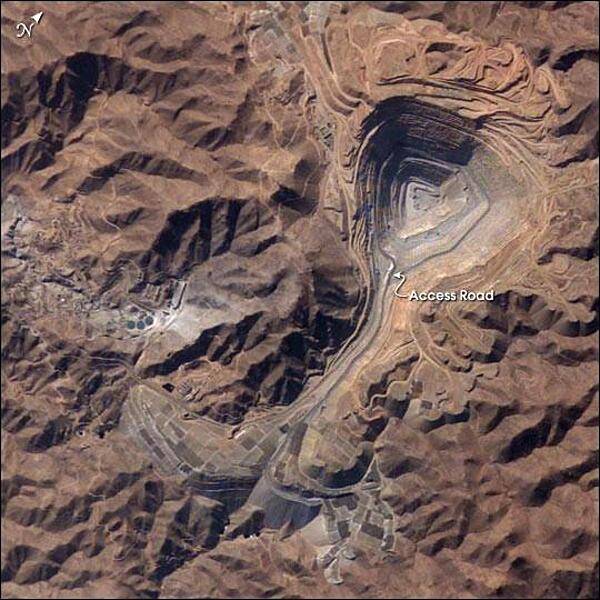
The rugged, mineral-rich Andes support some of the world's biggest mines (gold, silver, copper, and more). This image looks down the bull's-eye of Peru's Toquepala copper mine, a steep sided and stepped open-pit mine. Mid-afternoon sunlight on the arid slopes of the central Andes mountains provides an accent to the mine contours. At the surface, the open pit is 2.5 km (1.5 mi) across, and it descends more than 700 m (2,300 ft) into the earth. A dark line on the wall of the pit is the main access road to the bottom. Spoil dumps of material mined from the pit are arranged in tiers along the northwest lip of the pit. Numerous angular leaching fields appear lower right, and the railroad to the coast is a line that exits the image center left. The railroad was built to export Toquepala's copper and connects the coastal port of Ilo, 95 km (60 mi) to the southwest. Photo courtesy of NASA.
The rugged, mineral-rich Andes support some of the world's biggest mines (gold, silver, copper, and more). This image looks down the bull's-eye of Peru's Toquepala copper mine, a steep sided and stepped open-pit mine. Mid-afternoon sunlight on the arid slopes of the central Andes mountains provides an accent to the mine contours. At the surface, the open pit is 2.5 km (1.5 mi) across, and it descends more than 700 m (2,300 ft) into the earth. A dark line on the wall of the pit is the main access road to the bottom. Spoil dumps of material mined from the pit are arranged in tiers along the northwest lip of the pit. Numerous angular leaching fields appear lower right, and the railroad to the coast is a line that exits the image center left. The railroad was built to export Toquepala's copper and connects the coastal port of Ilo, 95 km (60 mi) to the southwest. Photo courtesy of NASA. • CIA World Factbook • 2020
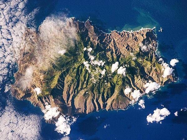
Saint Helena's rugged topography of sharp peaks and deep ravines - evident in this photograph from the International Space Station - is the result of erosion of the volcanic rocks that make up the island. A climatic gradient related to elevation is also evident - the higher, wetter central portion of the island is covered with green vegetation, whereas the lower coastal areas are drier and hotter with little vegetation cover. Image courtesy of NASA.
Saint Helena's rugged topography of sharp peaks and deep ravines - evident in this photograph from the International Space Station - is the result of erosion of the volcanic rocks that make up the island. A climatic gradient related to elevation is also evident - the higher, wetter central portion of the island is covered with green vegetation, whereas the lower coastal areas are drier and hotter with little vegetation cover. Image courtesy of NASA. • CIA World Factbook • 2020
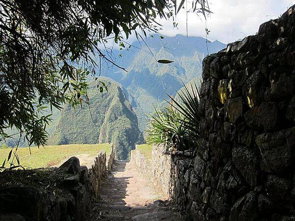
A section of the Inca Trail near the Machu Picchu ruins. The Trail between Cusco, the Inca's ancient capital, and the ruins is approximately 80 km (50 mi).
A section of the Inca Trail near the Machu Picchu ruins. The Trail between Cusco, the Inca's ancient capital, and the ruins is approximately 80 km (50 mi). • CIA World Factbook • 2020
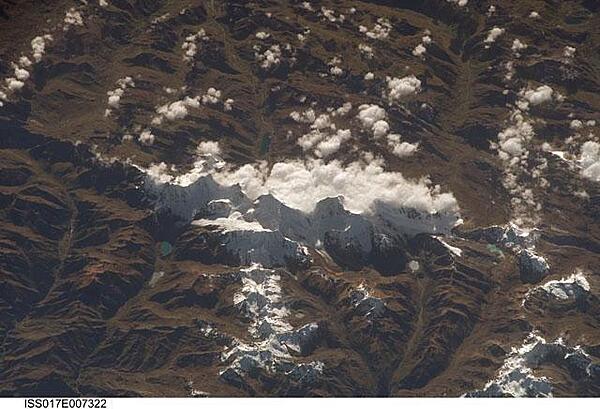
This view of the Peruvian Andes was taken looking east from the international space station flying off the Peruvian coast and shows Cordillera Huayhuash (pronounced Why-wash). Here clouds are banked up on the east side, snow covers all higher slopes and mountain peaks, and glaciers occupy lower slopes. This prominent but short mountain range (25 km or 15 mi in length) boasts twenty peaks of remarkable steepness and ridge sharpness. Although only 100 km (60 mi) from the coastline, six of the peaks reach above 6,000 m (more than 19,500 ft), the highest of which is Nevado Yerupaja, Peru's second highest peak, variously estimated as 6,617 and 6,635 m high. Generally considered the most spectacular peak in South America, Yerupaja is so steep that it has seldom been climbed. Photo courtesy of NASA.
This view of the Peruvian Andes was taken looking east from the international space station flying off the Peruvian coast and shows Cordillera Huayhuash (pronounced Why-wash). Here clouds are banked up on the east side, snow covers all higher slopes and mountain peaks, and glaciers occupy lower slopes. This prominent but short mountain range (25 km or 15 mi in length) boasts twenty peaks of remarkable steepness and ridge sharpness. Although only 100 km (60 mi) from the coastline, six of the peaks reach above 6,000 m (more than 19,500 ft), the highest of which is Nevado Yerupaja, Peru's second highest peak, variously estimated as 6,617 and 6,635 m high. Generally considered the most spectacular peak in South America, Yerupaja is so steep that it has seldom been climbed. Photo courtesy of NASA. • CIA World Factbook • 2020
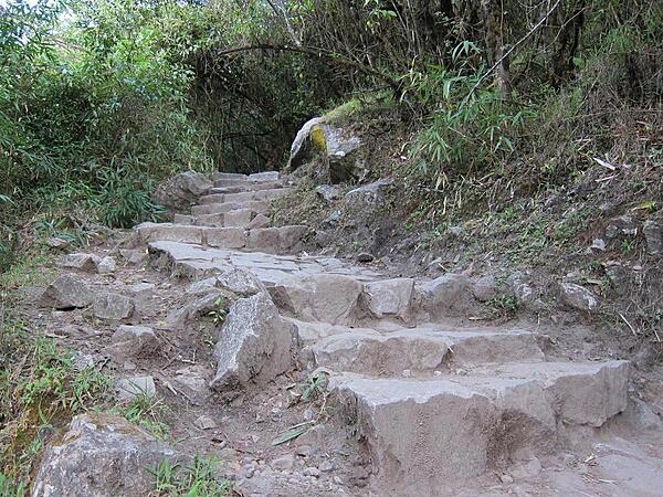
Steep rock steps on the Inca Trail are common. The majority of the trail's stones date back to the Inca Empire.
Steep rock steps on the Inca Trail are common. The majority of the trail's stones date back to the Inca Empire. • CIA World Factbook • 2020
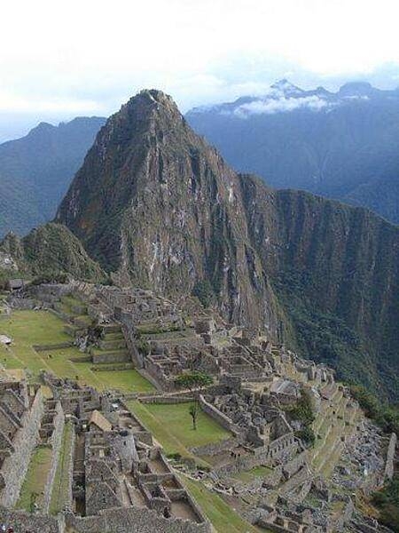
Machu Picchu has been declared a World Heritage Site and was named one of the "New" Seven Wonders of the World.
Machu Picchu has been declared a World Heritage Site and was named one of the "New" Seven Wonders of the World. • CIA World Factbook • 2020
76 photos available
View All Photos→Data sources: World Bank, UN Data • Updated daily •Learn about our data