›››
Philippines
Philippines
Population
115.8M
Rank #14Source: World Bank
Capital
Manila
Source: REST Countries
Region
Asia
East Asia & Pacific
Source: REST Countries
GDP (Nominal)
$461.62B
Rank #34Source: World Bank
Land Area
342.4K km²
Rank #65Source: REST Countries
Life Expectancy
69.833 yrs
Source: World Bank
Historical Trends
Population Trend (5-Year)
Source: World Bank
GDP Trend (5-Year, Nominal USD)
Source: World Bank
Geography
Area: 342,353 km²
Landlocked: No
Independent: Yes
Climate: tropical marine; northeast monsoon (November to April); southwest monsoon (May to October)
Terrain: mostly mountains with narrow to extensive coastal lowlands
Elevation: mean elevation: 442 m lowest point: Philippine Sea 0 m highest point: Mount Apo 2,954 m
Natural Hazards: astride typhoon belt, usually affected by 15 and struck by five to six cyclonic storms each year; landslides; active volcanoes; destructive earthquakes; tsunamisvolcanism: significant volcanic...
Environmental Issues: uncontrolled deforestation especially in watershed areas; illegal mining and logging; soil erosion; air and water pollution in major urban centers; coral reef degradation; increasing pollution of...
Land Use: agricultural land: 41% (2011 est.) forest: 25.9% (2011 est.) other: 33.1% (2011 est.)
Geography Note: note 1: for decades, the Philippine archipelago was reported as having 7,107 islands; in 2016, the national mapping authority reported that hundreds of new islands had been discovered and increased...
Natural Resources
timberpetroleumnickelcobaltsilvergoldsaltcopper
People & Society
Fertility Rate
1.92
Population
115.8M
Ethnic Groups
Tagalog (24.4%)Bisaya/Binisaya (11.4%)Cebuano (9.9%)Ilocano (8.8%)Hiligaynon/Ilonggo (8.4%)Bikol/Bicol (6.8%)Waray (4%)other local ethnicity (26.1%)other foreign ethnicity (0.1%)
Religions
Roman Catholic (80.6%)Protestant 8.2% (includes Philippine Council of Evangelical Churches (2.7%)National Council of Churches in the Philippines (1.2%)other Protestant (4.3%)other Christian (3.4%)Muslim (5.6%)tribal religions (0.2%)other (1.9%)none (0.1%)
Economy
GDP per Capita
$3,984.832
GDP per Capita PPP
11,794.138
(2024)
(2024)
GNI per Capita
4,470
(2024)
(2024)
Gini Index
39.3
(2023)
(2023)
Unemployment
2.202%
(2024)
(2024)
Inflation
3.213%
(2024)
(2024)
Public Debt
43.426%
(2014)
(2014)
Energy
Electricity Access
98%
(2023)
(2023)
Renewable Energy
28%
(2021)
(2021)
CO₂ Emissions
174.114 Mt
(2024)
(2024)
Energy Intensity
2.78 MJ/$
(2021)
(2021)
Renewable Electricity
22.721%
(2021)
(2021)
Environment
Forest Coverage
24.46% of land
(2023)
(2023)
Protected Areas
12.7% of land
(2006)
(2006)
Communications
Internet Users
83.766%
(2023)
(2023)
Mobile Penetration
117.276%
(2023)
(2023)
Broadband Subscribers
6.539%
(2023)
(2023)
Transportation
Air Transport Freight
649.207 M ton-km
(2023)
(2023)
Container Port Traffic
9,249,451 TEU
(2022)
(2022)
Airports
283,131
Rail Lines
509 km
Roads Total
N/A
Military
Military Forces
Armed Forces of the Philippines (AFP): Army, Navy (includes Marine Corps), Air Force note: the Philippine Coast Guard is an armed and uniformed service under the Department of Transportation; it...
Personnel Strength
the Armed Forces of the Philippines (AFP) have approximately 130,000 active duty personnel (90,000 Army; 24,000 Navy; 16,000 Air Force); note - the Navy includes about 8,500 marines)
Military Expenditure (USD)
$6.12B
Military Expenditure (% of GDP)
1.32%
Military Expenditure History
1% of GDP (2019) 0.9% of GDP (2018) 1.3% of GDP (2017) 1.1% of GDP (2016) 1.1% of GDP (2015)
Equipment & Inventories
the AFP is equipped with a mix of imported weapons systems, particularly second-hand equipment from the US; since 2014, its top weapons suppliers are Brazil, Indonesia, South Korea, and the US (2019)
Service Age & Obligation
18-23 years of age (officers 21-29) for voluntary military service; no conscription
Education
Pre-Primary Enrollment
90.225%
(2021)
(2021)
Primary Enrollment
94.033%
(2024)
(2024)
Secondary Enrollment
85.295%
(2024)
(2024)
Tertiary Enrollment
47.413%
(2024)
(2024)
Education Spending
3.925% of GDP
(2024)
(2024)
Adult Literacy Rate
98.47%
(2020)
(2020)
Pupil-Teacher Ratio
29.084:1
(2017)
(2017)
Health
Physicians per 1,000
0.792
(2021)
(2021)
Safe Water Access
95.859%
(2024)
(2024)
Safe Drinking Water
48.484%
(2024)
(2024)
Under-5 Mortality
26.9 per 1,000
(2023)
(2023)
Maternal Mortality (World Bank)
13.039 per 100,000
(2021)
(2021)
Hospital Beds per 1,000
69.883
(2021)
(2021)
UHC Coverage Index
69
(2023)
(2023)
Measles Immunization
71%
(2024)
(2024)
Social Indicators
Extreme Poverty Rate
5.3%
(2023)
(2023)
Food Insecurity
3%
(2023)
(2023)
Youth NEET Rate
6.902%
(2023)
(2023)
Governance
Women in Government
27.331%
(2024)
(2024)
Voice & Accountability
-0.02
(Below Average)
(2023)
(Below Average)
(2023)
Political Stability
-0.57
(Below Average)
(2023)
(Below Average)
(2023)
Government Effectiveness
0.15
(Above Average)
(2023)
(Above Average)
(2023)
Regulatory Quality
0.16
(Above Average)
(2023)
(Above Average)
(2023)
Rule of Law
-0.42
(Below Average)
(2023)
(Below Average)
(2023)
Control of Corruption
-0.54
(Below Average)
(2023)
(Below Average)
(2023)
Government
Government Type
presidential republic
Legal System
mixed legal system of civil, common, Islamic (sharia), and customary law
Executive Branch
chief of state: President Rodrigo DUTERTE (since 30 June 2016); Vice President Leni ROBREDO (since 30 June 2016); note - the president is both chief of state and head of government head of...
Legislative Branch
description: bicameral Congress or Kongreso consists of:Senate or Senado (24 seats; members directly elected in multi-seat constituencies by majority vote; members serve 6-year terms with one-half of...
Judicial Branch
highest courts: Supreme Court (consists of a chief justice and 14 associate justices) judge selection and term of office: justices are appointed by the president on the recommendation of the Judicial...
National Symbols
Flag Description
two equal horizontal bands of blue (top) and red; a white equilateral triangle is based on the hoist side; the center of the triangle displays a yellow sun with eight primary rays; each corner of the...
National Symbols
three stars and sun, Philippine eagle; national colors: red, white, blue, yellow
National Anthem
name: "Lupang Hinirang" (Chosen Land) lyrics/music: Jose PALMA (revised by Felipe PADILLA de Leon)/Julian FELIPE note: music adopted 1898, original Spanish lyrics adopted 1899, Filipino (Tagalog)...
Safety
Homicide Rate
4.348 per 100,000
(2023)
(2023)
Travel Information
Language(s): English, Filipino
Currency: PHP (₱)
Timezone(s): UTC+08:00
Landlocked: No
Independent: Yes
Driving Side: Right
Calling Code: +63
Car Sign: RP
Week Starts: Monday
Photos
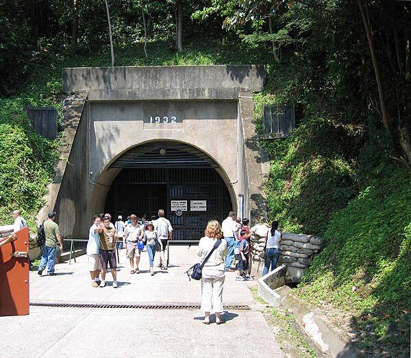
East entrance to the Malinta Tunnel complex on the island of Corregidor. Constructed by the US Army Corps of Engineers between 1922 and 1932, it was used for bomb-proof storage, as a command center, and a 1,000-bed hospital. The main east-west tunnel is 253 m (830 ft) long and 7.3 m (24 ft) wide, with 24 lateral tunnels, each about 49 m (160 ft) long and 4.6 m (15 ft) wide. A double track electric railway ran down the main tunnel. General Douglas MACARTHUR's headquarters and the offices of President Manuel L. QUEZON of the Philippines Commonwealth were located in laterals just inside this entrance.
East entrance to the Malinta Tunnel complex on the island of Corregidor. Constructed by the US Army Corps of Engineers between 1922 and 1932, it was used for bomb-proof storage, as a command center, and a 1,000-bed hospital. The main east-west tunnel is 253 m (830 ft) long and 7.3 m (24 ft) wide, with 24 lateral tunnels, each about 49 m (160 ft) long and 4.6 m (15 ft) wide. A double track electric railway ran down the main tunnel. General Douglas MACARTHUR's headquarters and the offices of President Manuel L. QUEZON of the Philippines Commonwealth were located in laterals just inside this entrance. • CIA World Factbook • 2020
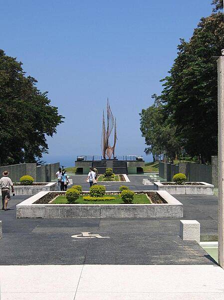
On the grounds of the Pacific War Memorial, Corregidor. The sculpture is entitled the "Eternal Flame of Freedom."
On the grounds of the Pacific War Memorial, Corregidor. The sculpture is entitled the "Eternal Flame of Freedom." • CIA World Factbook • 2020
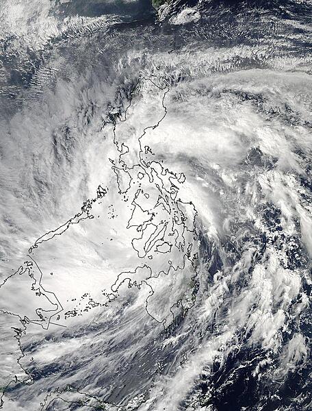
Super-Typhoon Haiyan slammed into the eastern Philippines on 7 November 2013 as the strongest tropical cyclone of the year. Just before making landfall its maximum sustained winds were 314 kph/195 mph, with gusts up to 379 kph/235 mph. PAGASA, the Philippines weather organization noted that Hiayan's maximum sustained winds at landfall were near 234 kph/145 mph. As Super-Typhoon Haiyan moved over the central Philippines on 8 November, NASA's Aqua satellite captured this visible image showing that Haiyan maintained its structure as it moved over the east central Philippines but that large, thick bands of thunderstorms spiraled into the center from the northeast. Image courtesy of NASA.
Super-Typhoon Haiyan slammed into the eastern Philippines on 7 November 2013 as the strongest tropical cyclone of the year. Just before making landfall its maximum sustained winds were 314 kph/195 mph, with gusts up to 379 kph/235 mph. PAGASA, the Philippines weather organization noted that Hiayan's maximum sustained winds at landfall were near 234 kph/145 mph. As Super-Typhoon Haiyan moved over the central Philippines on 8 November, NASA's Aqua satellite captured this visible image showing that Haiyan maintained its structure as it moved over the east central Philippines but that large, thick bands of thunderstorms spiraled into the center from the northeast. Image courtesy of NASA. • CIA World Factbook • 2020
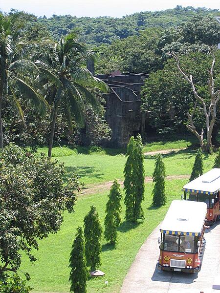
Tour busses pause in the vicinity of the Spanish Lighthouse on the island of Corregidor. In the background, amid the trees, are the remains of one of the senior officer's family quarters.
Tour busses pause in the vicinity of the Spanish Lighthouse on the island of Corregidor. In the background, amid the trees, are the remains of one of the senior officer's family quarters. • CIA World Factbook • 2020
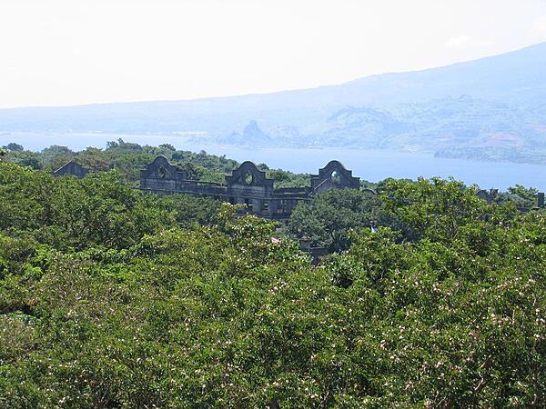
A view of Topside - the highest area of Corregidor - taken from the vicinity of the Spanish Lighthouse. Shown are the remains of the "Mile-Long Barracks" barely visible above the trees. These main barracks on the Topside section housed the troops of the coast artillery battalions who manned the island defenses. The building was a three-story concrete structure designed to be hurricane proof while providing comfortable, airy accommodations in a tropical environment. Despite the fact it never was a mile long when built, the structure was considered the longest barracks in the world. In the background, across the North Channel, are the mountains of Bataan Peninsula overlooking Corregidor.
A view of Topside - the highest area of Corregidor - taken from the vicinity of the Spanish Lighthouse. Shown are the remains of the "Mile-Long Barracks" barely visible above the trees. These main barracks on the Topside section housed the troops of the coast artillery battalions who manned the island defenses. The building was a three-story concrete structure designed to be hurricane proof while providing comfortable, airy accommodations in a tropical environment. Despite the fact it never was a mile long when built, the structure was considered the longest barracks in the world. In the background, across the North Channel, are the mountains of Bataan Peninsula overlooking Corregidor. • CIA World Factbook • 2020
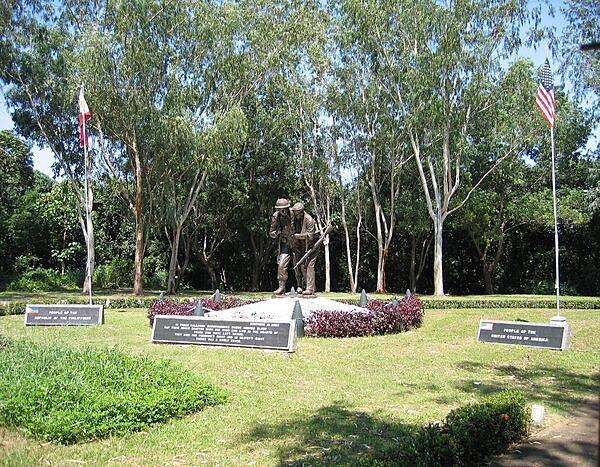
The 3 m (10 ft) bronze sculpture entitled "Brothers in Arms" highlights the Filipino-American Friendship Park on the island of Corregidor. The park lies directly behind the Pacific War Memorial.
The 3 m (10 ft) bronze sculpture entitled "Brothers in Arms" highlights the Filipino-American Friendship Park on the island of Corregidor. The park lies directly behind the Pacific War Memorial. • CIA World Factbook • 2020
33 photos available
View All Photos→Data sources: World Bank, UN Data • Updated daily •Learn about our data