›››
Pakistan
Pakistan
Population
251.3M
Rank #5Source: World Bank
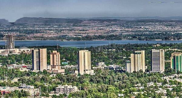
Capital
Islamabad
Source: REST Countries
Region
Africa
Middle East, North Africa, Afghanistan & Pakistan
Source: REST Countries
GDP (Nominal)
$371.57B
Rank #43Source: World Bank
Land Area
796.1K km²
Rank #36Source: REST Countries
Life Expectancy
67.649 yrs
Source: World Bank
Historical Trends
Population Trend (5-Year)
Source: World Bank
GDP Trend (5-Year, Nominal USD)
Source: World Bank
Geography
Area: 796,095 km²
Landlocked: No
Independent: Yes
Climate: mostly hot, dry desert; temperate in northwest; arctic in north
Terrain: divided into three major geographic areas: the northern highlands, the Indus River plain in the center and east, and the Balochistan Plateau in the south and west
Elevation: mean elevation: 900 m lowest point: Arabian Sea 0 m highest point: K2 (Mt. Godwin-Austen) 8,611 m
Natural Hazards: frequent earthquakes, occasionally severe especially in north and west; flooding along the Indus after heavy rains (July and August)
Environmental Issues: water pollution from raw sewage, industrial wastes, and agricultural runoff; limited natural freshwater resources; most of the population does not have access to potable water; deforestation; soil...
Land Use: agricultural land: 35.2% (2011 est.) forest: 2.1% (2011 est.) other: 62.7% (2011 est.)
Geography Note: controls Khyber Pass and Bolan Pass, traditional invasion routes between Central Asia and the Indian Subcontinent
Natural Resources
arable landextensive natural gas reserveslimited petroleumpoor quality coaliron orecoppersaltlimestone
People & Society
Fertility Rate
3.60
Population
251.3M
Ethnic Groups
Punjabi (44.7%)Pashtun (Pathan) (15.4%)Sindhi (14.1%)Saraiki (8.4%)Muhajirs (7.6%)Balochi (3.6%)other (6.3%)
Religions
Muslim (official) (96.4%)other (includes Christian and Hindu) (3.6%)
Economy
GDP per Capita
$1,478.773
GDP per Capita PPP
6,252.115
(2024)
(2024)
GNI per Capita
1,430
(2024)
(2024)
Gini Index
29.6
(2018)
(2018)
Unemployment
5.492%
(2024)
(2024)
Inflation
12.633%
(2024)
(2024)
Public Debt
Not Available
Energy
Electricity Access
95.6%
(2023)
(2023)
Renewable Energy
41.6%
(2021)
(2021)
CO₂ Emissions
203.988 Mt
(2024)
(2024)
Energy Intensity
4.21 MJ/$
(2021)
(2021)
Renewable Electricity
28.281%
(2021)
(2021)
Environment
Forest Coverage
4.672% of land
(2023)
(2023)
Communications
Internet Users
27.376%
(2023)
(2023)
Mobile Penetration
76.54%
(2023)
(2023)
Broadband Subscribers
1.356%
(2023)
(2023)
Transportation
Air Transport Freight
309.515 M ton-km
(2023)
(2023)
Container Port Traffic
3,383,580 TEU
(2022)
(2022)
Airports
41,823
Rail Lines
7,791 km
Roads Total
500,591 km(©IRF)
Military
Military Forces
Pakistan Army (includes National Guard), Pakistan Navy (includes marines, Maritime Security Agency), Pakistan Air Force (Pakistan Fizaia); Ministry of Interior paramilitary forces: Frontier Corps,...
Personnel Strength
estimates of the size of the Pakistan military’s active force vary; approximately 650,000 active personnel (560,000 Army; 30,000 Navy; 60,000 Air Force); est. 70,000 Frontier Corps; est. 25,000...
Military Expenditure (USD)
$10.17B
Military Expenditure (% of GDP)
2.67%
Military Expenditure History
4% of GDP (2019) 4.1% of GDP (2018) 3.8% of GDP (2017) 3.6% of GDP (2016) 3.6% of GDP (2015)
Deployments
1,230 Central African Republic (MINUSCA); 1,950 Democratic Republic of the Congo (MONUSCO); 140 Mali (MINUSMA); 900 Sudan (UNAMID) (2020)
Equipment & Inventories
the Pakistan military inventory includes a broad mix of equipment, primarily from China, France, Ukraine, the UK, and the US; since 2010, China and the US are the leading suppliers of arms to...
Service Age & Obligation
16-23 years of age for voluntary military service; soldiers cannot be deployed for combat until age 18; women serve in all three armed forces; reserve obligation to age 45 for enlisted men, age 50...
Education
Pre-Primary Enrollment
82.557%
(2019)
(2019)
Primary Enrollment
83.726%
(2024)
(2024)
Secondary Enrollment
48.281%
(2024)
(2024)
Tertiary Enrollment
10.856%
(2024)
(2024)
Education Spending
1.947% of GDP
(2023)
(2023)
Adult Literacy Rate
58.86%
(2021)
(2021)
Pupil-Teacher Ratio
44.077:1
(2018)
(2018)
Health
Physicians per 1,000
1.16
(2021)
(2021)
Safe Water Access
90.693%
(2024)
(2024)
Safe Drinking Water
44.974%
(2024)
(2024)
Under-5 Mortality
58.5 per 1,000
(2023)
(2023)
Maternal Mortality (World Bank)
16.927 per 100,000
(2021)
(2021)
Hospital Beds per 1,000
66.93
(2021)
(2021)
UHC Coverage Index
56
(2023)
(2023)
Measles Immunization
87%
(2024)
(2024)
Social Indicators
Extreme Poverty Rate
16.5%
(2018)
(2018)
Food Insecurity
16.5%
(2023)
(2023)
Youth NEET Rate
11.101%
(2021)
(2021)
Governance
Women in Government
17.042%
(2024)
(2024)
Voice & Accountability
-0.96
(Below Average)
(2023)
(Below Average)
(2023)
Political Stability
-1.93
(Weak)
(2023)
(Weak)
(2023)
Government Effectiveness
-0.58
(Below Average)
(2023)
(Below Average)
(2023)
Regulatory Quality
-0.90
(Below Average)
(2023)
(Below Average)
(2023)
Rule of Law
-0.86
(Below Average)
(2023)
(Below Average)
(2023)
Control of Corruption
-1.00
(Below Average)
(2023)
(Below Average)
(2023)
Government
Government Type
federal parliamentary republic
Legal System
common law system with Islamic law influence
Executive Branch
chief of state: President Arif ALVI (since 9 September 2018) head of government: Prime Minister Imran KHAN (since 18 August 2018) cabinet: Cabinet appointed by the president upon the advice of the...
Legislative Branch
description: bicameral Parliament or Majlis-e-Shoora consists of:Senate (104 seats; members indirectly elected by the 4 provincial assemblies and the territories' representatives by proportional...
Judicial Branch
highest courts: Supreme Court of Pakistan (consists of the chief justice and 16 judges) judge selection and term of office: justices nominated by an 8-member parliamentary committee upon the...
International Organizations
National Symbols
Flag Description
green with a vertical white band (symbolizing the role of religious minorities) on the hoist side; a large white crescent and star are centered in the green field; the crescent, star, and color green...
National Symbols
five-pointed star between the horns of a waxing crescent moon, jasmine; national colors: green, white
National Anthem
name: "Qaumi Tarana" (National Anthem) lyrics/music: Abu-Al-Asar Hafeez JULLANDHURI/Ahmed Ghulamali CHAGLA note: adopted 1954; also known as "Pak sarzamin shad bad" (Blessed Be the Sacred Land)
Safety
Homicide Rate
4.335 per 100,000
(2023)
(2023)
Travel Information
Language(s): English, Urdu
Currency: PKR (₨)
Timezone(s): UTC+05:00
Landlocked: No
Independent: Yes
Driving Side: Left
Calling Code: +92
Car Sign: PK
Week Starts: Monday
Photos
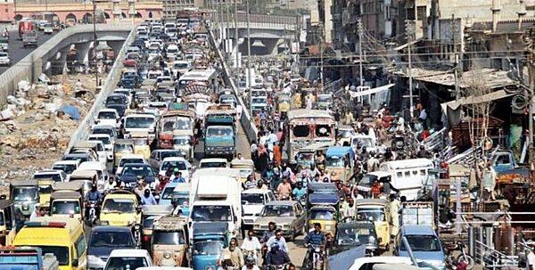
A centuries-old settlement that now ranks among the world's largest, Pakistan's seaport city of Karachi mixes intense urbanization with remnants of a natural environment. This true-color satellite image of Karachi shows the southwestern edges of the city. Two rivers, the Lyari and Malir, pass through Karachi en route to the Arabian Sea. The Lyari River passes north of the Port of Karachi, and expansive salt works, appearing as large geometric areas of green, line the northern edge of that river's delta. East of the port, the Malir River flows southward toward the sea. Between the port and the Arabian Sea, a barrier island runs northwest-southeast (left edge of the image). East of this island and west of the port sits a large expanse of water and mangroves. Water in the Lyari River Delta must empty into the sea through the Baba Channel. Sediment colors the water flowing through that channel a lighter color than the surrounding ocean. Immediately east of the Port of Karachi lie two more mangroves, the larger of which is named Chinna Creek. Many of Karachi's oldest structures and most popular tourist attractions appear in the city center just northeast of the port, but street grids cover almost all of the available land outside of the mangroves. Photo courtesy of NASA.
A centuries-old settlement that now ranks among the world's largest, Pakistan's seaport city of Karachi mixes intense urbanization with remnants of a natural environment. This true-color satellite image of Karachi shows the southwestern edges of the city.
Two rivers, the Lyari and Malir, pass through Karachi en route to the Arabian Sea. The Lyari River passes north of the Port of Karachi, and expansive salt works, appearing as large geometric areas of green, line the northern edge of that river's delta. East of the port, the Malir River flows southward toward the sea.
Between the port and the Arabian Sea, a barrier island runs northwest-southeast (left edge of the image). East of this island and west of the port sits a large expanse of water and mangroves. Water in the Lyari River Delta must empty into the sea through the Baba Channel. Sediment colors the water flowing through that channel a lighter color than the surrounding ocean. Immediately east of the Port of Karachi lie two more mangroves, the larger of which is named Chinna Creek.
Many of Karachi's oldest structures and most popular tourist attractions appear in the city center just northeast of the port, but street grids cover almost all of the available land outside of the mangroves. Photo courtesy of NASA. • CIA World Factbook • 2020
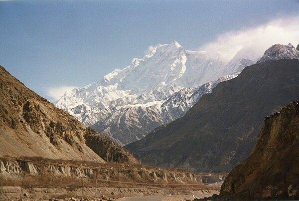
This view shows K-2 Mountain (upper center) in Pakistan, the world's second highest peak, as seen from the International Space Station. The mountain (8,611 m; 28,251 ft high) is sometimes referred to as Savage Mountain, because of the difficulty of its ascent and the many lives lost in attempting its climb. Image courtesy of NASA.
This view shows K-2 Mountain (upper center) in Pakistan, the world's second highest peak, as seen from the International Space Station. The mountain (8,611 m; 28,251 ft high) is sometimes referred to as Savage Mountain, because of the difficulty of its ascent and the many lives lost in attempting its climb. Image courtesy of NASA. • CIA World Factbook • 2020
The Karakoram Highway between Gilgit and Khunjerab Pass. A joint Chinese-Pakistan venture, the 1,300 km highway connects Gilgit-Baltistan in Pakistan with the Xinjiang Uygur Autonomous Region in China. It is one of the highest all-weather roads in the world crossing the Khunjerab Pass over the Karakoram Mountains at an elevation of 4,714 m. The highway follows one of the branches of the ancient Silk Road.
The Karakoram Highway between Gilgit and Khunjerab Pass. A joint Chinese-Pakistan venture, the 1,300 km highway connects Gilgit-Baltistan in Pakistan with the Xinjiang Uygur Autonomous Region in China. It is one of the highest all-weather roads in the world crossing the Khunjerab Pass over the Karakoram Mountains at an elevation of 4,714 m. The highway follows one of the branches of the ancient Silk Road. • CIA World Factbook • 2020
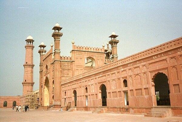
The entrance to the Badshahi Mosque, or “imperial mosque,” as viewed from the mosque courtyard. The mosque, built by the Mughal emperor Aurangzeb from 1671-1673, is the last great mosque built during the Mughal period; its courtyard can accommodate 100,000 worshipers. The gateway leads out to the garden known as Hazuri Bagh, beyond which is the Alamgiri gate of the Lahore Fort.
The entrance to the Badshahi Mosque, or “imperial mosque,” as viewed from the mosque courtyard. The mosque, built by the Mughal emperor Aurangzeb from 1671-1673, is the last great mosque built during the Mughal period; its courtyard can accommodate 100,000 worshipers. The gateway leads out to the garden known as Hazuri Bagh, beyond which is the Alamgiri gate of the Lahore Fort. • CIA World Factbook • 2020
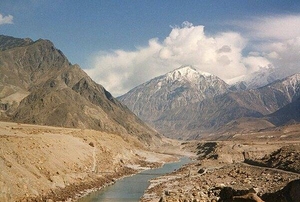
The Indus River as it flows through the mountainous region of Gilgit-Baltistan in Pakistan.
The Indus River as it flows through the mountainous region of Gilgit-Baltistan in Pakistan. • CIA World Factbook • 2020
The Hunza Valley in the Northern Areas is believed to have served as the inspiration for the novel Lost Horizons.
The Hunza Valley in the Northern Areas is believed to have served as the inspiration for the novel Lost Horizons. • CIA World Factbook • 2020
10 photos available
View All Photos→Data sources: World Bank, UN Data • Updated daily •Learn about our data