›››
Pakistan — Media Gallery
10 items available (flags, maps, photos)
Photos
A centuries-old settlement that now ranks among the world's largest, Pakistan's seaport city of Karachi mixes intense urbanization with remnants of a natural environment. This true-color satellite image of Karachi shows the southwestern edges of the city. Two rivers, the Lyari and Malir, pass through Karachi en route to the Arabian Sea. The Lyari River passes north of the Port of Karachi, and expansive salt works, appearing as large geometric areas of green, line the northern edge of that river's delta. East of the port, the Malir River flows southward toward the sea. Between the port and the Arabian Sea, a barrier island runs northwest-southeast (left edge of the image). East of this island and west of the port sits a large expanse of water and mangroves. Water in the Lyari River Delta must empty into the sea through the Baba Channel. Sediment colors the water flowing through that channel a lighter color than the surrounding ocean. Immediately east of the Port of Karachi lie two more mangroves, the larger of which is named Chinna Creek. Many of Karachi's oldest structures and most popular tourist attractions appear in the city center just northeast of the port, but street grids cover almost all of the available land outside of the mangroves. Photo courtesy of NASA.
A centuries-old settlement that now ranks among the world's largest, Pakistan's seaport city of Karachi mixes intense urbanization with remnants of a natural environment. This true-color satellite image of Karachi shows the southwestern edges of the city.
Two rivers, the Lyari and Malir, pass through Karachi en route to the Arabian Sea. The Lyari River passes north of the Port of Karachi, and expansive salt works, appearing as large geometric areas of green, line the northern edge of that river's delta. East of the port, the Malir River flows southward toward the sea.
Between the port and the Arabian Sea, a barrier island runs northwest-southeast (left edge of the image). East of this island and west of the port sits a large expanse of water and mangroves. Water in the Lyari River Delta must empty into the sea through the Baba Channel. Sediment colors the water flowing through that channel a lighter color than the surrounding ocean. Immediately east of the Port of Karachi lie two more mangroves, the larger of which is named Chinna Creek.
Many of Karachi's oldest structures and most popular tourist attractions appear in the city center just northeast of the port, but street grids cover almost all of the available land outside of the mangroves. Photo courtesy of NASA. • CIA World Factbook • 2020
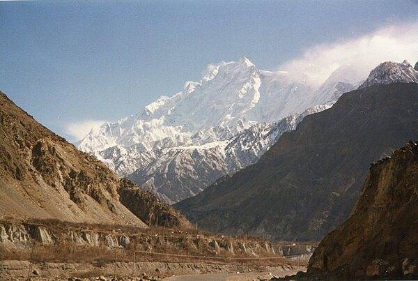
This view shows K-2 Mountain (upper center) in Pakistan, the world's second highest peak, as seen from the International Space Station. The mountain (8,611 m; 28,251 ft high) is sometimes referred to as Savage Mountain, because of the difficulty of its ascent and the many lives lost in attempting its climb. Image courtesy of NASA.
This view shows K-2 Mountain (upper center) in Pakistan, the world's second highest peak, as seen from the International Space Station. The mountain (8,611 m; 28,251 ft high) is sometimes referred to as Savage Mountain, because of the difficulty of its ascent and the many lives lost in attempting its climb. Image courtesy of NASA. • CIA World Factbook • 2020
The Karakoram Highway between Gilgit and Khunjerab Pass. A joint Chinese-Pakistan venture, the 1,300 km highway connects Gilgit-Baltistan in Pakistan with the Xinjiang Uygur Autonomous Region in China. It is one of the highest all-weather roads in the world crossing the Khunjerab Pass over the Karakoram Mountains at an elevation of 4,714 m. The highway follows one of the branches of the ancient Silk Road.
The Karakoram Highway between Gilgit and Khunjerab Pass. A joint Chinese-Pakistan venture, the 1,300 km highway connects Gilgit-Baltistan in Pakistan with the Xinjiang Uygur Autonomous Region in China. It is one of the highest all-weather roads in the world crossing the Khunjerab Pass over the Karakoram Mountains at an elevation of 4,714 m. The highway follows one of the branches of the ancient Silk Road. • CIA World Factbook • 2020
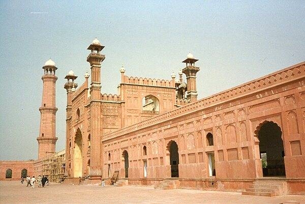
The entrance to the Badshahi Mosque, or “imperial mosque,” as viewed from the mosque courtyard. The mosque, built by the Mughal emperor Aurangzeb from 1671-1673, is the last great mosque built during the Mughal period; its courtyard can accommodate 100,000 worshipers. The gateway leads out to the garden known as Hazuri Bagh, beyond which is the Alamgiri gate of the Lahore Fort.
The entrance to the Badshahi Mosque, or “imperial mosque,” as viewed from the mosque courtyard. The mosque, built by the Mughal emperor Aurangzeb from 1671-1673, is the last great mosque built during the Mughal period; its courtyard can accommodate 100,000 worshipers. The gateway leads out to the garden known as Hazuri Bagh, beyond which is the Alamgiri gate of the Lahore Fort. • CIA World Factbook • 2020
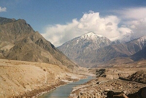
The Indus River as it flows through the mountainous region of Gilgit-Baltistan in Pakistan.
The Indus River as it flows through the mountainous region of Gilgit-Baltistan in Pakistan. • CIA World Factbook • 2020
The Hunza Valley in the Northern Areas is believed to have served as the inspiration for the novel Lost Horizons.
The Hunza Valley in the Northern Areas is believed to have served as the inspiration for the novel Lost Horizons. • CIA World Factbook • 2020

CIA World Factbook • 2020
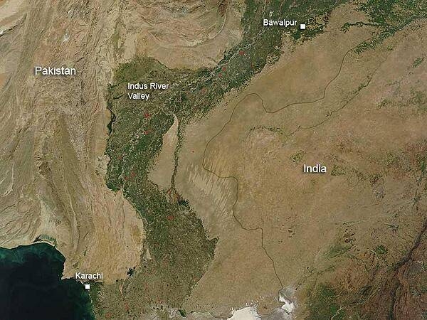
This satellite image dramatically delineates the fertile and well-watered lower Indus Valley in Pakistan and the more arid areas to the east (Thar Desert in India) and west (Balochistan Plateau). Red dots indicate burning fires. Image courtesy of NASA.
This satellite image dramatically delineates the fertile and well-watered lower Indus Valley in Pakistan and the more arid areas to the east (Thar Desert in India) and west (Balochistan Plateau). Red dots indicate burning fires. Image courtesy of NASA. • CIA World Factbook • 2020
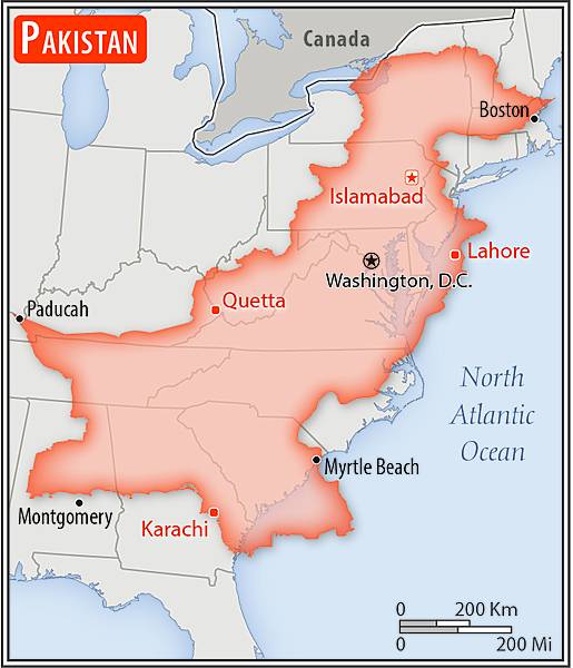
Area comparison map
Area comparison map • CIA World Factbook • 2020
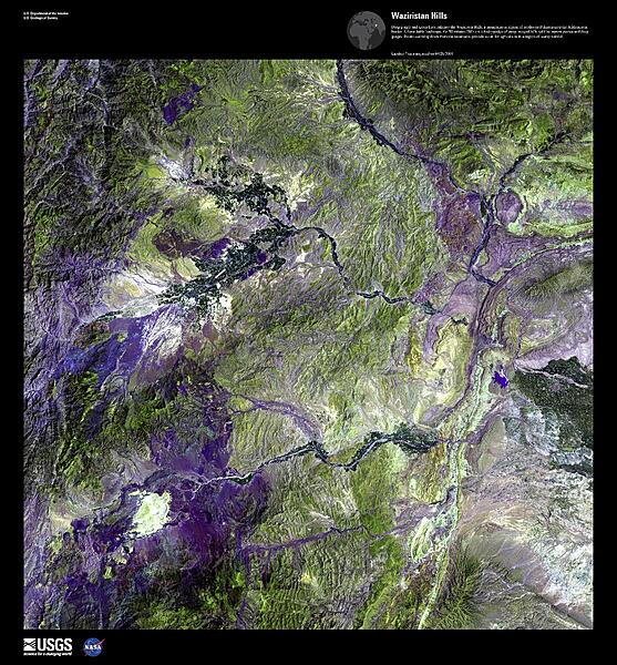
Deep purple and green hues in this false-color satellite image enhance the Waziristan Hills, a mountainous region of northwest Pakistan near the Afghanistan border. A formidable landscape, the Waziristan Hills are a hodgepodge of steep, rugged hills split by narrow passes and deep gorges. Rivers coursing down from the mountains provide water for agriculture in a region of scanty rainfall. Image courtesy of USGS.
Deep purple and green hues in this false-color satellite image enhance the Waziristan Hills, a mountainous region of northwest Pakistan near the Afghanistan border. A formidable landscape, the Waziristan Hills are a hodgepodge of steep, rugged hills split by narrow passes and deep gorges. Rivers coursing down from the mountains provide water for agriculture in a region of scanty rainfall. Image courtesy of USGS. • CIA World Factbook • 2020
Media source: CIA World Factbook (2020) — Public Domain