›››
Portugal
Portugal
Population
10.7M
Rank #89Source: World Bank
Capital
Lisbon
Source: REST Countries
Region
Europe
Europe & Central Asia
Source: REST Countries
GDP (Nominal)
$313.27B
Rank #46Source: World Bank
Land Area
92.1K km²
Rank #110Source: REST Countries
Life Expectancy
82.28 yrs
Source: World Bank
Historical Trends
Population Trend (5-Year)
Source: World Bank
GDP Trend (5-Year, Nominal USD)
Source: World Bank
Geography
Area: 92,090 km²
Landlocked: No
Independent: Yes
Climate: maritime temperate; cool and rainy in north, warmer and drier in south
Terrain: the west-flowing Tagus River divides the country: the north is mountainous toward the interior, while the south is characterized by rolling plains
Elevation: mean elevation: 372 m lowest point: Atlantic Ocean 0 m highest point: Ponta do Pico (Pico or Pico Alto) on Ilha do Pico in the Azores 2,351 m
Natural Hazards: Azores subject to severe earthquakesvolcanism: limited volcanic activity in the Azores Islands; Fayal or Faial (1,043 m) last erupted in 1958; most volcanoes have not erupted in centuries;...
Environmental Issues: soil erosion; air pollution caused by industrial and vehicle emissions; water pollution, especially in urban centers and coastal areas
Land Use: agricultural land: 39.7% (2011 est.) forest: 37.8% (2011 est.) other: 22.5% (2011 est.)
Geography Note: Azores and Madeira Islands occupy strategic locations along western sea approaches to Strait of Gibraltar; they are two of the four North Atlantic archipelagos that make up Macaronesia; the others...
Natural Resources
fishforests (cork)iron orecopperzinctintungstensilvergolduranium
People & Society
Fertility Rate
1.44
Population
10.7M
Religions
Roman Catholic (81%)other Christian (3.3%)other (includes Jewish, Muslim) (0.6%)none (6.8%)unspecified (8.3%)
Economy
GDP per Capita
$29,292.242
GDP per Capita PPP
51,679.888
(2024)
(2024)
GNI per Capita
26,910
(2024)
(2024)
Gini Index
33.9
(2023)
(2023)
Unemployment
6.5%
(2024)
(2024)
Inflation
2.416%
(2024)
(2024)
Public Debt
Not Available
Energy
Electricity Access
100%
(2023)
(2023)
Renewable Energy
32.3%
(2021)
(2021)
CO₂ Emissions
35.557 Mt
(2024)
(2024)
Energy Intensity
2.31 MJ/$
(2022)
(2022)
Renewable Electricity
64.906%
(2021)
(2021)
Environment
Forest Coverage
36.155% of land
(2023)
(2023)
Communications
Internet Users
88.487%
(2024)
(2024)
Mobile Penetration
123.002%
(2023)
(2023)
Broadband Subscribers
44.111%
(2023)
(2023)
Transportation
Air Transport Freight
568.979 M ton-km
(2023)
(2023)
Container Port Traffic
2,794,454 TEU
(2022)
(2022)
Airports
178,916.4
Rail Lines
2,527.053 km
Roads Total
14,338.9 km(©IRF)
Military
Military Forces
Portuguese Armed Forces: Portuguese Army (Exercito Portuguesa), Portuguese Navy (Marinha Portuguesa; includes Marine Corps), Portuguese Air Force (Forca Aerea Portuguesa, FAP); Portuguese National...
Personnel Strength
the Portuguese Armed Forces have approximately 26,500 active duty personnel (13,000 Army; 7,500 Navy; 6,000 Air Force); 24,700 National Republican Guard (military personnel)
Military Expenditure (USD)
$4.64B
Military Expenditure (% of GDP)
1.53%
Military Expenditure History
1.52% of GDP (2019 est.) 1.43% of GDP (2018) 1.25% of GDP (2017) 1.27% of GDP (2016) 1.33% of GDP (2015)
Deployments
190 Afghanistan (NATO); 200 Central African Republic (MINUSCA/EUTM); up to 120 Baltic States (NATO) (2020)
Equipment & Inventories
the Portuguese Armed Forces inventory includes mostly European and US-origin weapons systems along with a smaller mix of domestically-produced equipment; since 2010, Germany and the US are the...
Service Age & Obligation
18-30 years of age for voluntary or contract military service; no compulsory military service, but conscription possible if insufficient volunteers available; women serve in the armed forces, on...
Education
Pre-Primary Enrollment
99.359%
(2020)
(2020)
Primary Enrollment
110.989%
(2023)
(2023)
Secondary Enrollment
120.347%
(2023)
(2023)
Tertiary Enrollment
77.678%
(2023)
(2023)
Education Spending
4.552% of GDP
(2022)
(2022)
Adult Literacy Rate
94.48%
(2011)
(2011)
Pupil-Teacher Ratio
12.353:1
(2017)
(2017)
Health
Physicians per 1,000
5.851
(2022)
(2022)
Safe Water Access
99.288%
(2024)
(2024)
Safe Drinking Water
95.217%
(2024)
(2024)
Under-5 Mortality
3.2 per 1,000
(2023)
(2023)
Maternal Mortality (World Bank)
21.855 per 100,000
(2021)
(2021)
Hospital Beds per 1,000
78.273
(2021)
(2021)
UHC Coverage Index
83
(2023)
(2023)
Measles Immunization
99%
(2024)
(2024)
Social Indicators
Extreme Poverty Rate
0.4%
(2023)
(2023)
Food Insecurity
2.5%
(2023)
(2023)
Youth NEET Rate
21.63%
(2024)
(2024)
Governance
Women in Government
32.609%
(2024)
(2024)
Voice & Accountability
1.21
(Strong)
(2023)
(Strong)
(2023)
Political Stability
0.71
(Above Average)
(2023)
(Above Average)
(2023)
Government Effectiveness
0.99
(Above Average)
(2023)
(Above Average)
(2023)
Regulatory Quality
0.76
(Above Average)
(2023)
(Above Average)
(2023)
Rule of Law
1.07
(Strong)
(2023)
(Strong)
(2023)
Control of Corruption
0.70
(Above Average)
(2023)
(Above Average)
(2023)
Government
Government Type
semi-presidential republic
Legal System
civil law system; Constitutional Court review of legislative acts
Executive Branch
chief of state: President Marcelo REBELO DE SOUSA (since 9 March 2016) head of government: Prime Minister Antonio Luis Santos da COSTA (since 24 November 2015) cabinet: Council of Ministers appointed...
Legislative Branch
description: unicameral Assembly of the Republic or Assembleia da Republica (230 seats; 226 members directly elected in multi-seat constituencies by closed-list proportional representation vote and 4...
Judicial Branch
highest courts: Supreme Court or Supremo Tribunal de Justica (consists of 12 justices); Constitutional Court or Tribunal Constitucional (consists of 13 judges) judge selection and term of...
International Organizations
National Symbols
Flag Description
two vertical bands of green (hoist side, two-fifths) and red (three-fifths) with the national coat of arms (armillary sphere and Portuguese shield) centered on the dividing line; explanations for the...
National Symbols
armillary sphere (a spherical astrolabe modeling objects in the sky and representing the Republic); national colors: red, green
National Anthem
name: "A Portugesa" (The Song of the Portuguese) lyrics/music: Henrique LOPES DE MENDOCA/Alfredo KEIL note: adopted 1910; "A Portuguesa" was originally written to protest the Portuguese monarchy's...
Safety
Homicide Rate
0.72 per 100,000
(2022)
(2022)
Travel Information
Language(s): Portuguese
Currency: EUR (€)
Timezone(s): UTC to -01:00
Landlocked: No
Independent: Yes
Driving Side: Right
Calling Code: +351
Car Sign: P
Week Starts: Monday
Photos
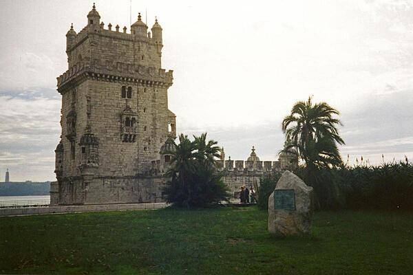
The Torre de Belem (Belem Tower) was built in the early 16th century to commemorate Vasco de Gama's voyages of discovery to India (1497-1524).
The Torre de Belem (Belem Tower) was built in the early 16th century to commemorate Vasco de Gama's voyages of discovery to India (1497-1524). • CIA World Factbook • 2020
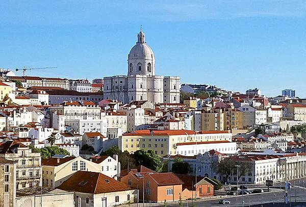
Lisbon, Portugal's capital and largest city, is often called the “White City." The center of this scene shows the Church of Santa Engracia, a 17th-century monument. Originally a church, it was converted in the 20th century into a National Pantheon in which important Portuguese personalities are buried.
Lisbon, Portugal's capital and largest city, is often called the “White City." The center of this scene shows the Church of Santa Engracia, a 17th-century monument. Originally a church, it was converted in the 20th century into a National Pantheon in which important Portuguese personalities are buried. • CIA World Factbook • 2020
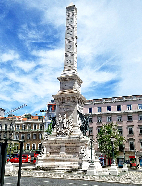
The Monument to the Restorers in Lisbon was erected in 1886 to celebrate the restoration of Portuguese independence from Spain in 1640.
The Monument to the Restorers in Lisbon was erected in 1886 to celebrate the restoration of Portuguese independence from Spain in 1640. • CIA World Factbook • 2020
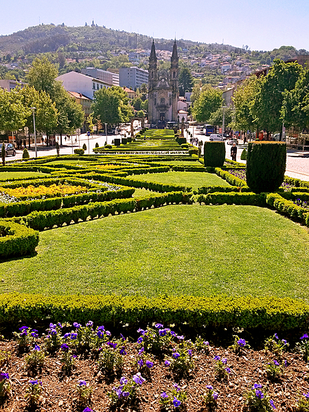
The medieval section of Guimaraes opens onto the “Largo Republica do Brasil (Republic Square of Brazil)” with its formal flower gardens. One end of the square features the slim Nossa Senhora da Consolacao e dos Santos Passos (Church of Our Lady of Consolation and the Holy Steps), one of the loveliest examples of Portuguese Baroque architecture.
The medieval section of Guimaraes opens onto the “Largo Republica do Brasil (Republic Square of Brazil)” with its formal flower gardens. One end of the square features the slim Nossa Senhora da Consolacao e dos Santos Passos (Church of Our Lady of Consolation and the Holy Steps), one of the loveliest examples of Portuguese Baroque architecture. • CIA World Factbook • 2020
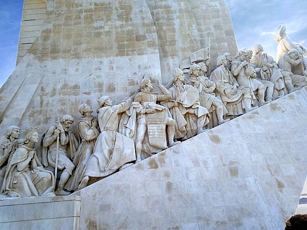
Closeup of the figures on the west side of the Padrao dos descobrimentos (Monument to the Discoveries) in Lisbon, which honors monarchs, explorers, navigators, cartographers, scientists, and missionaries from the Age of Discovery (15th and 16th centuries). The main statue of Henry the Navigator (1394-1460), holding a model of a carrack, leads a procession of 32 figures (16 on either side ramp) on the monument.
Closeup of the figures on the west side of the Padrao dos descobrimentos (Monument to the Discoveries) in Lisbon, which honors monarchs, explorers, navigators, cartographers, scientists, and missionaries from the Age of Discovery (15th and 16th centuries). The main statue of Henry the Navigator (1394-1460), holding a model of a carrack, leads a procession of 32 figures (16 on either side ramp) on the monument. • CIA World Factbook • 2020
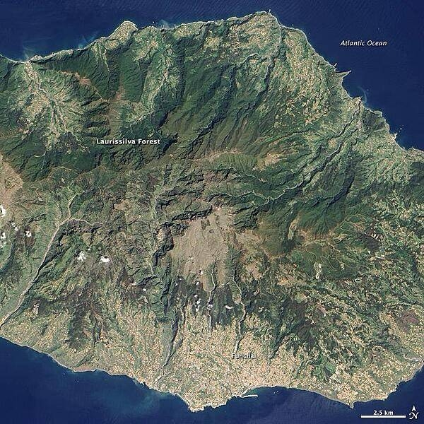
Located in the Atlantic Ocean about 700 km off the coast of North Africa, Madeira Island is the top of a giant shield volcano that rises 6 km from the ocean floor to reach an altitude of 1,862 m above sea level. When Portuguese explorers arrived there in the early 1400s, they were so impressed with the thick forest covering the steep, mountainous island that they called it Ilhe de Madeira, Island of Wood. The forest of Madeira is known as Laurissilva, a forest that is similar to high-altitude tropical rain forests ("cloud forests"). Laurissilva is a relic of the forest that once thrived across southern Europe and North Africa, but which disappeared as the last ice age ended and the regional climate became hotter and drier. Madeira's mild, subtropical climate and isolation preserved the laurel forest as it became extinct elsewhere. The surviving Laurissilva is both a natural reserve and a World Heritage Site. The remaining forest covers about 15,000 ha, making it the largest Laurissilva forest in the world. About 90% of the forest is believed to be old growth, primary forest, according to the UN. The Laurissilva includes a wide diversity of flora, including a number of rare ferns and flowering plants. Image courtesy of NASA.
Located in the Atlantic Ocean about 700 km off the coast of North Africa, Madeira Island is the top of a giant shield volcano that rises 6 km from the ocean floor to reach an altitude of 1,862 m above sea level. When Portuguese explorers arrived there in the early 1400s, they were so impressed with the thick forest covering the steep, mountainous island that they called it Ilhe de Madeira, Island of Wood.
The forest of Madeira is known as Laurissilva, a forest that is similar to high-altitude tropical rain forests ("cloud forests"). Laurissilva is a relic of the forest that once thrived across southern Europe and North Africa, but which disappeared as the last ice age ended and the regional climate became hotter and drier. Madeira's mild, subtropical climate and isolation preserved the laurel forest as it became extinct elsewhere.
The surviving Laurissilva is both a natural reserve and a World Heritage Site. The remaining forest covers about 15,000 ha, making it the largest Laurissilva forest in the world. About 90% of the forest is believed to be old growth, primary forest, according to the UN. The Laurissilva includes a wide diversity of flora, including a number of rare ferns and flowering plants. Image courtesy of NASA. • CIA World Factbook • 2020
24 photos available
View All Photos→Data sources: World Bank, UN Data • Updated daily •Learn about our data