›››
Russian Federation
Russian Federation
Population
143.5M
Rank #9Source: World Bank
Capital
Moscow
Source: REST Countries
Region
Europe
Europe & Central Asia
Source: REST Countries
GDP (Nominal)
$2.17T
Rank #11Source: World Bank
Land Area
17.1M km²
Rank #1Source: REST Countries
Life Expectancy
73.255 yrs
Source: World Bank
Historical Trends
Population Trend (5-Year)
Source: World Bank
GDP Trend (5-Year, Nominal USD)
Source: World Bank
Geography
Area: 17,098,246 km²
Landlocked: No
Independent: Yes
Climate: ranges from steppes in the south through humid continental in much of European Russia; subarctic in Siberia to tundra climate in the polar north; winters vary from cool along Black Sea coast to...
Terrain: broad plain with low hills west of Urals; vast coniferous forest and tundra in Siberia; uplands and mountains along southern border regions
Elevation: mean elevation: 600 m lowest point: Caspian Sea -28 m highest point: Gora El'brus (highest point in Europe) 5,642 m
Natural Hazards: permafrost over much of Siberia is a major impediment to development; volcanic activity in the Kuril Islands; volcanoes and earthquakes on the Kamchatka Peninsula; spring floods and summer/autumn...
Environmental Issues: air pollution from heavy industry, emissions of coal-fired electric plants, and transportation in major cities; industrial, municipal, and agricultural pollution of inland waterways and seacoasts;...
Land Use: agricultural land: 13.1% (2011 est.) forest: 49.4% (2011 est.) other: 37.5% (2011 est.)
Geography Note: note 1: largest country in the world in terms of area but unfavorably located in relation to major sea lanes of the world; despite its size, much of the country lacks proper soils and climates...
Natural Resources
wide natural resource base including major deposits of oilnatural gascoaland many strategic mineralsbauxitereserves of rare earth elementstimbernoteformidable obstacles of climateterrain
People & Society
Fertility Rate
1.41
Population
143.5M
Ethnic Groups
Russian (77.7%)Tatar (3.7%)Ukrainian (1.4%)Bashkir (1.1%)Chuvash (1%)Chechen (1%)other (10.2%)unspecified (3.9%)
Religions
other Christian (2%)
Economy
GDP per Capita
$14,889.019
GDP per Capita PPP
47,404.965
(2024)
(2024)
GNI per Capita
15,320
(2024)
(2024)
Gini Index
33
(2023)
(2023)
Unemployment
2.43%
(2024)
(2024)
Inflation
8.435%
(2024)
(2024)
Public Debt
18.503%
(2023)
(2023)
Energy
Electricity Access
100%
(2023)
(2023)
Renewable Energy
3.5%
(2021)
(2021)
CO₂ Emissions
2,009.154 Mt
(2024)
(2024)
Energy Intensity
8.46 MJ/$
(2021)
(2021)
Renewable Electricity
19.154%
(2021)
(2021)
Environment
Forest Coverage
49.784% of land
(2023)
(2023)
Protected Areas
2.43% of land
(2009)
(2009)
Communications
Internet Users
94.365%
(2024)
(2024)
Mobile Penetration
180.842%
(2023)
(2023)
Broadband Subscribers
25.824%
(2023)
(2023)
Transportation
Air Transport Freight
1,268.809 M ton-km
(2023)
(2023)
Container Port Traffic
3,914,304 TEU
(2022)
(2022)
Airports
783,868
Rail Lines
85,544 km
Roads Total
1,579,922.9 km(©IRF)
Military
Military Forces
Armed Forces of the Russian Federation: Ground Troops (Sukhoputnyye Voyskia, SV), Navy (Voyenno-Morskoy Flot, VMF), Aerospace Forces (Vozdushno-Kosmicheskiye Sily, VKS); Airborne Troops...
Personnel Strength
size estimates for the Armed Forces of the Russian Federation vary; approximately 900,000 total active duty troops (400,000 Ground Troops, including 40,000 Airborne Troops; 150,000 Navy; 200,000...
Military Expenditure (USD)
$148.97B
Military Expenditure (% of GDP)
7.05%
Military Expenditure History
3.9% of GDP (2019) 3.8% of GDP (2018) 4.2% of GDP (2017) 5.5% of GDP (2016) 4.9% of GDP (2015)
Deployments
est. 3,000-5,000 Armenia; est. 1,500 Belarus; est. 7,000-10,000 Georgia; est. 500 Kyrgyzstan; est. 1,500 Moldova; est. 4,000-5,000 Syria; est. 5,000-7,000 Tajikistan; est. 25,000-31,000 Ukraine;...
Equipment & Inventories
the Russian Federation's military and paramilitary services are equipped with domestically-produced weapons systems, although since 2010 Russia has imported limited amounts of military hardware from...
Service Age & Obligation
18-27 years of age for compulsory or voluntary military service; males are registered for the draft at 17 years of age; one-year service obligation (Russia offers the option of serving on a two-year...
Education
Pre-Primary Enrollment
85.993%
(2019)
(2019)
Primary Enrollment
97.746%
(2023)
(2023)
Secondary Enrollment
92.484%
(2023)
(2023)
Tertiary Enrollment
60.389%
(2024)
(2024)
Education Spending
4.165% of GDP
(2023)
(2023)
Adult Literacy Rate
99.93%
(2021)
(2021)
Pupil-Teacher Ratio
21.259:1
(2017)
(2017)
Health
Physicians per 1,000
5.111
(2022)
(2022)
Safe Water Access
96.9%
(2024)
(2024)
Safe Drinking Water
76.261%
(2024)
(2024)
Under-5 Mortality
4.5 per 1,000
(2023)
(2023)
Maternal Mortality (World Bank)
14.192 per 100,000
(2021)
(2021)
Hospital Beds per 1,000
70.017
(2021)
(2021)
UHC Coverage Index
81
(2023)
(2023)
Measles Immunization
97%
(2024)
(2024)
Social Indicators
Extreme Poverty Rate
0.1%
(2023)
(2023)
Food Insecurity
2.5%
(2023)
(2023)
Youth NEET Rate
8.306%
(2024)
(2024)
Governance
Women in Government
16.444%
(2024)
(2024)
Voice & Accountability
-1.29
(Weak)
(2023)
(Weak)
(2023)
Political Stability
-1.13
(Weak)
(2023)
(Weak)
(2023)
Government Effectiveness
-0.71
(Below Average)
(2023)
(Below Average)
(2023)
Regulatory Quality
-1.12
(Weak)
(2023)
(Weak)
(2023)
Rule of Law
-1.19
(Weak)
(2023)
(Weak)
(2023)
Control of Corruption
-1.10
(Weak)
(2023)
(Weak)
(2023)
Government
Government Type
semi-presidential federation
Legal System
civil law system; judicial review of legislative acts
Executive Branch
chief of state: President Vladimir Vladimirovich PUTIN (since 7 May 2012) head of government: Premier Mikhail MISHUSTIN (since 16 January 2020); First Deputy Premier Andrey Removich BELOUSOV (since...
Legislative Branch
description: bicameral Federal Assembly or Federalnoye Sobraniye consists of:Federation Council or Sovet Federatsii (170 seats; 2 members in each of the 83 federal administrative units (see note...
Judicial Branch
highest courts: Supreme Court of the Russian Federation (consists of 170 members organized into the Judicial Panel for Civil Affairs, the Judicial Panel for Criminal Affairs, and the Military Panel);...
International Organizations
National Symbols
Flag Description
three equal horizontal bands of white (top), blue, and rednote: the colors may have been based on those of the Dutch flag; despite many popular interpretations, there is no official meaning assigned...
National Symbols
bear, double-headed eagle; national colors: white, blue, red
National Anthem
name: "Gimn Rossiyskoy Federatsii" (National Anthem of the Russian Federation) lyrics/music: Sergey Vladimirovich MIKHALKOV/Aleksandr Vasilyevich ALEKSANDROV note: in 2000, Russia adopted the tune of...
Safety
Homicide Rate
6.765 per 100,000
(2021)
(2021)
Travel Information
Language(s): Russian
Currency: RUB (₽)
Timezone(s): UTC +03:00 to +12:00
Landlocked: No
Independent: Yes
Driving Side: Right
Calling Code: +7
Car Sign: RUS
Week Starts: Monday
Photos
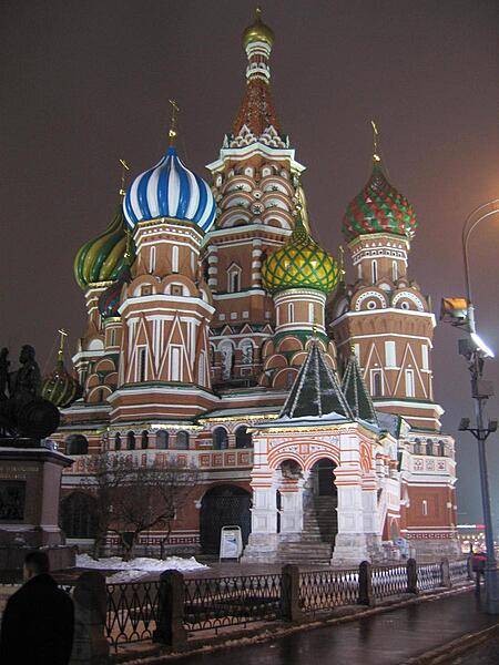
Saint Basil's Cathedral, Moscow in winter.
Saint Basil's Cathedral, Moscow in winter. • CIA World Factbook • 2020
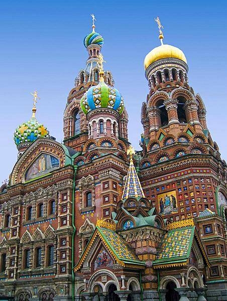
The Cathedral of the Resurrection of Christ in Saint Petersburg - also known as the Church of the Savior on Spilled Blood - was built on the site of the assassination of Alexander II. Its richly decorated façade and "onion domes" resemble those of the celebrated Saint Basil's Cathedral in Moscow.
The Cathedral of the Resurrection of Christ in Saint Petersburg - also known as the Church of the Savior on Spilled Blood - was built on the site of the assassination of Alexander II. Its richly decorated façade and "onion domes" resemble those of the celebrated Saint Basil's Cathedral in Moscow. • CIA World Factbook • 2020
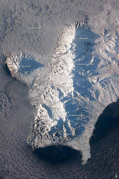
The Kuril Island chain is built from a line of volcanoes, an island arc, that extends from Russia's Kamchatka Peninsula to northern Japan. Island arcs form along an active boundary between two tectonic plates, with one being driven beneath the other (subduction). Magma generated by subduction feeds volcanoes - and eventually volcanic islands - over the subduction boundary. Paramushir Island in the northern Kurils is an example of a large island built by several volcanoes over geologic time. This astronaut photograph shows the southern end of Paramushir Island after a snowfall. The western slopes of the mountains are brightly illuminated, while the eastern slopes are in shadow. Four major volcanic centers create this part of the island. Fuss Peak (image center left) is an isolated stratovolcano connected to the main island via an isthmus. Fuss Peak last erupted in 1854. The southern tip of the island is occupied by the Karpinsky Group of three volcanic centers. A minor eruption of ash following an earthquake occurred on this part of the island in 1952. The Lomonosov Group to the northeast (image center) includes four cinder cones and a lava dome. The most recent volcanic activity on Paramushir Island occurred in 2008 at the Chikurachki cone located along the northern coastline of the island at image top center. The summit of this volcano, 1,816 m (5,958 ft) above sea level, is the highest on Paramushir Island. Much of the Sea of Okhotsk visible in the image is covered with low clouds that often form around the islands in the Kuril chain. The clouds are generated by moisture-laden air passing over the cool sea/ocean water, and they typically wrap around the volcanic islands. Image courtesy of NASA.
The Kuril Island chain is built from a line of volcanoes, an island arc, that extends from Russia's Kamchatka Peninsula to northern Japan. Island arcs form along an active boundary between two tectonic plates, with one being driven beneath the other (subduction). Magma generated by subduction feeds volcanoes - and eventually volcanic islands - over the subduction boundary. Paramushir Island in the northern Kurils is an example of a large island built by several volcanoes over geologic time. This astronaut photograph shows the southern end of Paramushir Island after a snowfall. The western slopes of the mountains are brightly illuminated, while the eastern slopes are in shadow.
Four major volcanic centers create this part of the island. Fuss Peak (image center left) is an isolated stratovolcano connected to the main island via an isthmus. Fuss Peak last erupted in 1854.
The southern tip of the island is occupied by the Karpinsky Group of three volcanic centers. A minor eruption of ash following an earthquake occurred on this part of the island in 1952.
The Lomonosov Group to the northeast (image center) includes four cinder cones and a lava dome.
The most recent volcanic activity on Paramushir Island occurred in 2008 at the Chikurachki cone located along the northern coastline of the island at image top center. The summit of this volcano, 1,816 m (5,958 ft) above sea level, is the highest on Paramushir Island.
Much of the Sea of Okhotsk visible in the image is covered with low clouds that often form around the islands in the Kuril chain. The clouds are generated by moisture-laden air passing over the cool sea/ocean water, and they typically wrap around the volcanic islands. Image courtesy of NASA. • CIA World Factbook • 2020
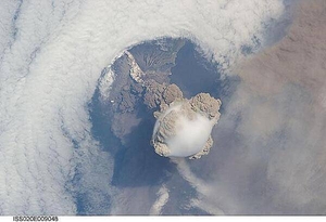
A fortuitous orbit of the International Space Station allowed the astronauts to take this striking view of Sarychev Peak volcano (Russia's Kuril Islands, northeast of Japan) in an early stage of eruption on 12 June 2009. Sarychev Peak is one of the most active volcanoes in the Kuril Island chain and is located on the northwestern end of Matua Island. Prior to 12 June, the last explosive eruption had occurred in 1989 with eruptions in 1986, 1976, 1954, and 1946 also producing lava flows. This detailed photograph is exciting to volcanologists because it captures several phenomena that occur during the earliest stages of an explosive volcanic eruption. The main column is one of a series of plumes that rose above Matua Island on June 12. The plume appears to be a combination of brown ash and white steam. The vigorously rising plume gives the steam a bubble-like appearance; the surrounding atmosphere has been shoved up by the shock wave of the eruption. The smooth white cloud on top may be water condensation that resulted from rapid rising and cooling of the air mass above the ash column, and is probably a transient feature (the eruption plume is starting to punch through). The structure also indicates that little or no shearing winds were present at the time to disrupt the plume. By contrast, a cloud of denser, gray ash - most probably a pyroclastic flow - appears to be hugging the ground, descending from the volcano summit. The rising eruption plume casts a shadow to the northwest of the island (bottom center). Brown ash at a lower altitude of the atmosphere spreads out above the ground at upper right. Low-level stratus clouds approach Matua Island from the east, wrapping around the lower slopes of the volcano. Only about 1.5 km (1 mi) of the coastline of Matua Island (upper center) can be seen beneath the clouds and ash. Image courtesy of NASA.
A fortuitous orbit of the International Space Station allowed the astronauts to take this striking view of Sarychev Peak volcano (Russia's Kuril Islands, northeast of Japan) in an early stage of eruption on 12 June 2009. Sarychev Peak is one of the most active volcanoes in the Kuril Island chain and is located on the northwestern end of Matua Island. Prior to 12 June, the last explosive eruption had occurred in 1989 with eruptions in 1986, 1976, 1954, and 1946 also producing lava flows.
This detailed photograph is exciting to volcanologists because it captures several phenomena that occur during the earliest stages of an explosive volcanic eruption. The main column is one of a series of plumes that rose above Matua Island on June 12. The plume appears to be a combination of brown ash and white steam. The vigorously rising plume gives the steam a bubble-like appearance; the surrounding atmosphere has been shoved up by the shock wave of the eruption. The smooth white cloud on top may be water condensation that resulted from rapid rising and cooling of the air mass above the ash column, and is probably a transient feature (the eruption plume is starting to punch through).
The structure also indicates that little or no shearing winds were present at the time to disrupt the plume. By contrast, a cloud of denser, gray ash - most probably a pyroclastic flow - appears to be hugging the ground, descending from the volcano summit. The rising eruption plume casts a shadow to the northwest of the island (bottom center).
Brown ash at a lower altitude of the atmosphere spreads out above the ground at upper right. Low-level stratus clouds approach Matua Island from the east, wrapping around the lower slopes of the volcano. Only about 1.5 km (1 mi) of the coastline of Matua Island (upper center) can be seen beneath the clouds and ash. Image courtesy of NASA. • CIA World Factbook • 2020
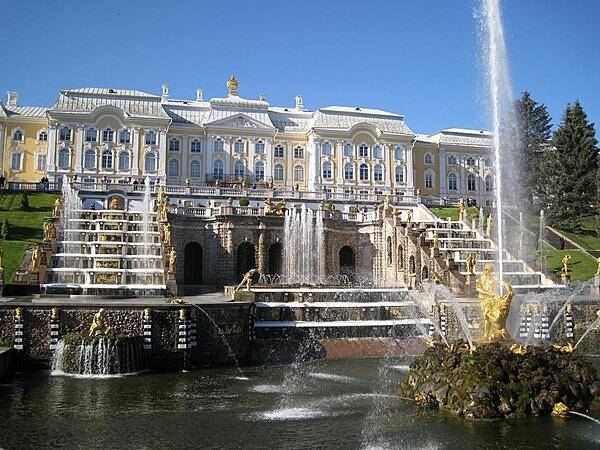
Peterhof Palace, near Saint Petersburg, sits atop a hill overlooking the Gulf of Finland. The Palace boasts a remarkable array of 64 decorative fountains, including a spectacular sculpture of Samson prying open the jaws of a lion as water cascades down terraced steps in the background. This was Peter I's summer palace.
Peterhof Palace, near Saint Petersburg, sits atop a hill overlooking the Gulf of Finland. The Palace boasts a remarkable array of 64 decorative fountains, including a spectacular sculpture of Samson prying open the jaws of a lion as water cascades down terraced steps in the background. This was Peter I's summer palace. • CIA World Factbook • 2020
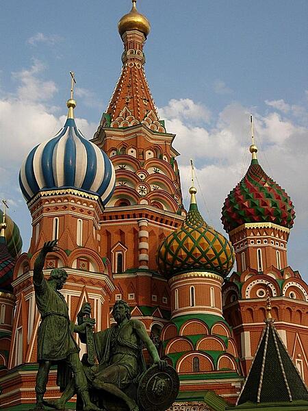
Close up of some of the colorful domes of Saint Basil's Cathedral in Moscow.
Close up of some of the colorful domes of Saint Basil's Cathedral in Moscow. • CIA World Factbook • 2020
36 photos available
View All Photos→Data sources: World Bank, UN Data • Updated daily •Learn about our data