›››
Russian Federation — Media Gallery
36 items available (flags, maps, photos)
Photos
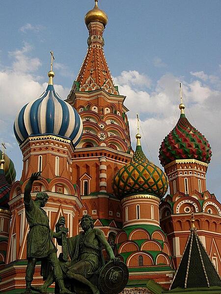
Close up of some of the colorful domes of Saint Basil's Cathedral in Moscow.
Close up of some of the colorful domes of Saint Basil's Cathedral in Moscow. • CIA World Factbook • 2020
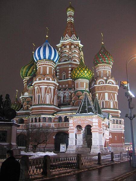
Saint Basil's Cathedral, Moscow in winter.
Saint Basil's Cathedral, Moscow in winter. • CIA World Factbook • 2020
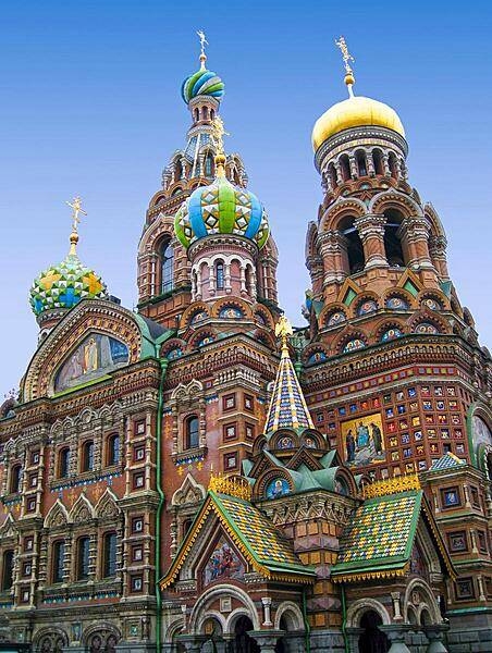
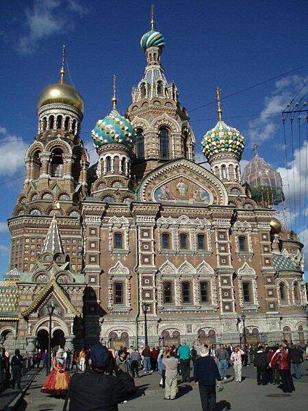
The Cathedral of the Resurrection of Christ in Saint Petersburg - also known as the Church of the Savior on Spilled Blood - was built on the site of the assassination of Alexander II. Its richly decorated façade and "onion domes" resemble those of the celebrated Saint Basil's Cathedral in Moscow.
The Cathedral of the Resurrection of Christ in Saint Petersburg - also known as the Church of the Savior on Spilled Blood - was built on the site of the assassination of Alexander II. Its richly decorated façade and "onion domes" resemble those of the celebrated Saint Basil's Cathedral in Moscow. • CIA World Factbook • 2020
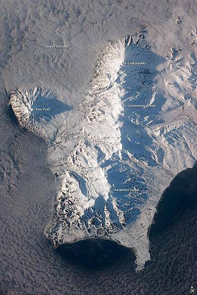
The Kuril Island chain is built from a line of volcanoes, an island arc, that extends from Russia's Kamchatka Peninsula to northern Japan. Island arcs form along an active boundary between two tectonic plates, with one being driven beneath the other (subduction). Magma generated by subduction feeds volcanoes - and eventually volcanic islands - over the subduction boundary. Paramushir Island in the northern Kurils is an example of a large island built by several volcanoes over geologic time. This astronaut photograph shows the southern end of Paramushir Island after a snowfall. The western slopes of the mountains are brightly illuminated, while the eastern slopes are in shadow. Four major volcanic centers create this part of the island. Fuss Peak (image center left) is an isolated stratovolcano connected to the main island via an isthmus. Fuss Peak last erupted in 1854. The southern tip of the island is occupied by the Karpinsky Group of three volcanic centers. A minor eruption of ash following an earthquake occurred on this part of the island in 1952. The Lomonosov Group to the northeast (image center) includes four cinder cones and a lava dome. The most recent volcanic activity on Paramushir Island occurred in 2008 at the Chikurachki cone located along the northern coastline of the island at image top center. The summit of this volcano, 1,816 m (5,958 ft) above sea level, is the highest on Paramushir Island. Much of the Sea of Okhotsk visible in the image is covered with low clouds that often form around the islands in the Kuril chain. The clouds are generated by moisture-laden air passing over the cool sea/ocean water, and they typically wrap around the volcanic islands. Image courtesy of NASA.
The Kuril Island chain is built from a line of volcanoes, an island arc, that extends from Russia's Kamchatka Peninsula to northern Japan. Island arcs form along an active boundary between two tectonic plates, with one being driven beneath the other (subduction). Magma generated by subduction feeds volcanoes - and eventually volcanic islands - over the subduction boundary. Paramushir Island in the northern Kurils is an example of a large island built by several volcanoes over geologic time. This astronaut photograph shows the southern end of Paramushir Island after a snowfall. The western slopes of the mountains are brightly illuminated, while the eastern slopes are in shadow.
Four major volcanic centers create this part of the island. Fuss Peak (image center left) is an isolated stratovolcano connected to the main island via an isthmus. Fuss Peak last erupted in 1854.
The southern tip of the island is occupied by the Karpinsky Group of three volcanic centers. A minor eruption of ash following an earthquake occurred on this part of the island in 1952.
The Lomonosov Group to the northeast (image center) includes four cinder cones and a lava dome.
The most recent volcanic activity on Paramushir Island occurred in 2008 at the Chikurachki cone located along the northern coastline of the island at image top center. The summit of this volcano, 1,816 m (5,958 ft) above sea level, is the highest on Paramushir Island.
Much of the Sea of Okhotsk visible in the image is covered with low clouds that often form around the islands in the Kuril chain. The clouds are generated by moisture-laden air passing over the cool sea/ocean water, and they typically wrap around the volcanic islands. Image courtesy of NASA. • CIA World Factbook • 2020
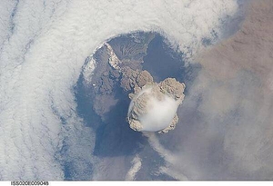
A fortuitous orbit of the International Space Station allowed the astronauts to take this striking view of Sarychev Peak volcano (Russia's Kuril Islands, northeast of Japan) in an early stage of eruption on 12 June 2009. Sarychev Peak is one of the most active volcanoes in the Kuril Island chain and is located on the northwestern end of Matua Island. Prior to 12 June, the last explosive eruption had occurred in 1989 with eruptions in 1986, 1976, 1954, and 1946 also producing lava flows. This detailed photograph is exciting to volcanologists because it captures several phenomena that occur during the earliest stages of an explosive volcanic eruption. The main column is one of a series of plumes that rose above Matua Island on June 12. The plume appears to be a combination of brown ash and white steam. The vigorously rising plume gives the steam a bubble-like appearance; the surrounding atmosphere has been shoved up by the shock wave of the eruption. The smooth white cloud on top may be water condensation that resulted from rapid rising and cooling of the air mass above the ash column, and is probably a transient feature (the eruption plume is starting to punch through). The structure also indicates that little or no shearing winds were present at the time to disrupt the plume. By contrast, a cloud of denser, gray ash - most probably a pyroclastic flow - appears to be hugging the ground, descending from the volcano summit. The rising eruption plume casts a shadow to the northwest of the island (bottom center). Brown ash at a lower altitude of the atmosphere spreads out above the ground at upper right. Low-level stratus clouds approach Matua Island from the east, wrapping around the lower slopes of the volcano. Only about 1.5 km (1 mi) of the coastline of Matua Island (upper center) can be seen beneath the clouds and ash. Image courtesy of NASA.
A fortuitous orbit of the International Space Station allowed the astronauts to take this striking view of Sarychev Peak volcano (Russia's Kuril Islands, northeast of Japan) in an early stage of eruption on 12 June 2009. Sarychev Peak is one of the most active volcanoes in the Kuril Island chain and is located on the northwestern end of Matua Island. Prior to 12 June, the last explosive eruption had occurred in 1989 with eruptions in 1986, 1976, 1954, and 1946 also producing lava flows.
This detailed photograph is exciting to volcanologists because it captures several phenomena that occur during the earliest stages of an explosive volcanic eruption. The main column is one of a series of plumes that rose above Matua Island on June 12. The plume appears to be a combination of brown ash and white steam. The vigorously rising plume gives the steam a bubble-like appearance; the surrounding atmosphere has been shoved up by the shock wave of the eruption. The smooth white cloud on top may be water condensation that resulted from rapid rising and cooling of the air mass above the ash column, and is probably a transient feature (the eruption plume is starting to punch through).
The structure also indicates that little or no shearing winds were present at the time to disrupt the plume. By contrast, a cloud of denser, gray ash - most probably a pyroclastic flow - appears to be hugging the ground, descending from the volcano summit. The rising eruption plume casts a shadow to the northwest of the island (bottom center).
Brown ash at a lower altitude of the atmosphere spreads out above the ground at upper right. Low-level stratus clouds approach Matua Island from the east, wrapping around the lower slopes of the volcano. Only about 1.5 km (1 mi) of the coastline of Matua Island (upper center) can be seen beneath the clouds and ash. Image courtesy of NASA. • CIA World Factbook • 2020
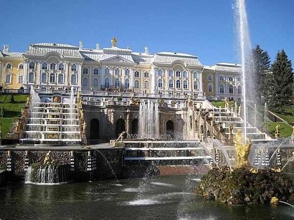
Peterhof Palace, near Saint Petersburg, sits atop a hill overlooking the Gulf of Finland. The Palace boasts a remarkable array of 64 decorative fountains, including a spectacular sculpture of Samson prying open the jaws of a lion as water cascades down terraced steps in the background. This was Peter I's summer palace.
Peterhof Palace, near Saint Petersburg, sits atop a hill overlooking the Gulf of Finland. The Palace boasts a remarkable array of 64 decorative fountains, including a spectacular sculpture of Samson prying open the jaws of a lion as water cascades down terraced steps in the background. This was Peter I's summer palace. • CIA World Factbook • 2020
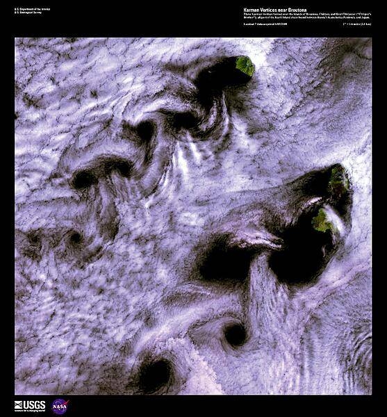
When wind-driven clouds encounter obstacles, in this case islands, they flow around them to form large, spinning eddies known as Karman vortices. The Karman vortices in this high-resolution satellite photo formed over the islands of Broutona, Chirpoy, and Brat Chirpoyev (Chirpoy's Brother), all part of the Kuril Island chain found between Russia's Kamchatka Peninsula and Japan. Image courtesy of USGS.
When wind-driven clouds encounter obstacles, in this case islands, they flow around them to form large, spinning eddies known as Karman vortices. The Karman vortices in this high-resolution satellite photo formed over the islands of Broutona, Chirpoy, and Brat Chirpoyev (Chirpoy's Brother), all part of the Kuril Island chain found between Russia's Kamchatka Peninsula and Japan. Image courtesy of USGS. • CIA World Factbook • 2020
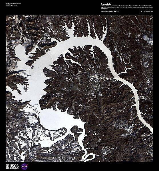
Nicknamed "Dragon Lake," this body of water is formed by the Bratskove Reservoir, built along the Angara River in southern Siberia, near the city of Bratsk. At its inauguration in 1967, the Reservoir was the largest artificial lake in the world with a surface area of 5,470 sq km (2,110 sq mi). This high-resolution satellite image was acquired in winter, when the lake was frozen. Image courtesy of USGS.
Nicknamed "Dragon Lake," this body of water is formed by the Bratskove Reservoir, built along the Angara River in southern Siberia, near the city of Bratsk. At its inauguration in 1967, the Reservoir was the largest artificial lake in the world with a surface area of 5,470 sq km (2,110 sq mi). This high-resolution satellite image was acquired in winter, when the lake was frozen. Image courtesy of USGS. • CIA World Factbook • 2020
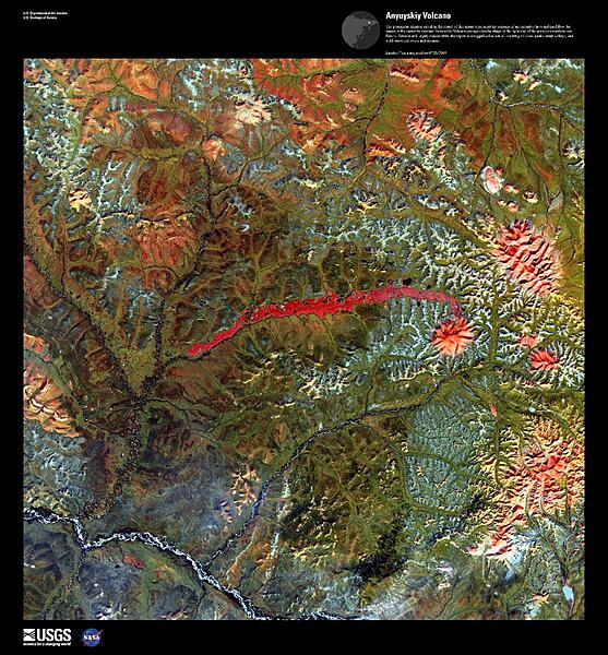
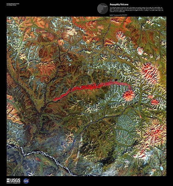
The prominent crimson streak in the center of this false-color satellite image represents the remains of a 50 km (31 mi) lahar (volcanic mudflow) that cut a strip of barren rock through rich vegetation surrounding the Anyuyskiy Volcano. The currently dormant volcano is the orange circular shape at the right end of the streak. Remote and largely inaccessible, the Kamchatka Peninsula is a rugged collection of towering volcanic peaks, steep valleys, active geysers, and wild, snow-fed rivers and streams. This volcano is part of the UNESCO World Heritage Site "Volcanoes of Kamchatka." For other active volcanoes in Russia, see the Natural hazards-volcanism subfield in the Geography section. Image courtesy of USGS.
The prominent crimson streak in the center of this false-color satellite image represents the remains of a 50 km (31 mi) lahar (volcanic mudflow) that cut a strip of barren rock through rich vegetation surrounding the Anyuyskiy Volcano. The currently dormant volcano is the orange circular shape at the right end of the streak. Remote and largely inaccessible, the Kamchatka Peninsula is a rugged collection of towering volcanic peaks, steep valleys, active geysers, and wild, snow-fed rivers and streams. This volcano is part of the UNESCO World Heritage Site "Volcanoes of Kamchatka." For other active volcanoes in Russia, see the Natural hazards-volcanism subfield in the Geography section. Image courtesy of USGS. • CIA World Factbook • 2020
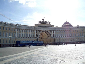
The General Staff Building in Saint Petersburg's Palace Square was built in the 1820s. The arch commemorates the victory over Napoleon; it is topped by a bronze sculpture of Victory herself riding a six-horse chariot. Under the Russian Empire, the West Wing housed the General Staff, while the East Wing contained the Foreign Ministry and the Finance Ministry. The building is now part of the Hermitage Museum.
The General Staff Building in Saint Petersburg's Palace Square was built in the 1820s. The arch commemorates the victory over Napoleon; it is topped by a bronze sculpture of Victory herself riding a six-horse chariot. Under the Russian Empire, the West Wing housed the General Staff, while the East Wing contained the Foreign Ministry and the Finance Ministry. The building is now part of the Hermitage Museum. • CIA World Factbook • 2020
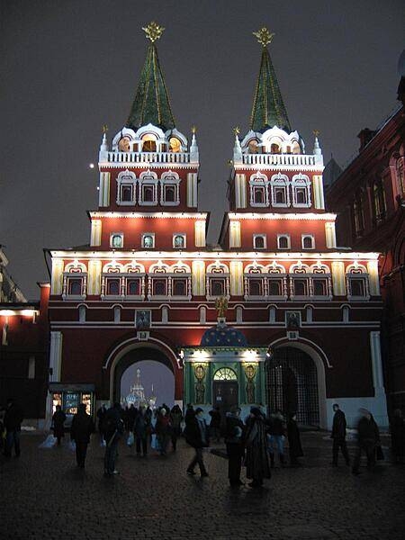
The Chapel of the Iveron Icon of the Mother of God was built in 1781 over the Voskresensky (Resurrection) Gate in Moscow to hold a replica of a Greek icon brought from Greece in 1669. The Soviet Government removed the chapel in 1929 and the gate in 1931. Both were rebuilt between 1994 and 1996. The gate leads to Red Square (Saint Basil's Cathedral may be seen through the opening).
The Chapel of the Iveron Icon of the Mother of God was built in 1781 over the Voskresensky (Resurrection) Gate in Moscow to hold a replica of a Greek icon brought from Greece in 1669. The Soviet Government removed the chapel in 1929 and the gate in 1931. Both were rebuilt between 1994 and 1996. The gate leads to Red Square (Saint Basil's Cathedral may be seen through the opening). • CIA World Factbook • 2020
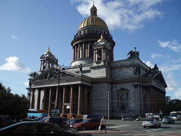
Saint Isaac's Cathedral in Saint Petersburg is the largest in the city. Its neoclassic exterior masks its sumptuously decorated interior.
Saint Isaac's Cathedral in Saint Petersburg is the largest in the city. Its neoclassic exterior masks its sumptuously decorated interior. • CIA World Factbook • 2020
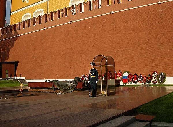
The Tomb of the Unknown Soldier in Moscow is a war memorial dedicated to Soviet soldiers killed during World War II. It is located in the Alexander Garden at the Kremlin Wall. First unveiled in 1967, a tombstone was added in 1975. The eternal flame emanates from the center of a five-pointed star located in front of the tombstone.
The Tomb of the Unknown Soldier in Moscow is a war memorial dedicated to Soviet soldiers killed during World War II. It is located in the Alexander Garden at the Kremlin Wall. First unveiled in 1967, a tombstone was added in 1975. The eternal flame emanates from the center of a five-pointed star located in front of the tombstone. • CIA World Factbook • 2020
CIA World Factbook • 2020
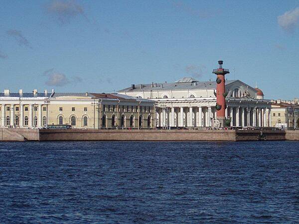
The Old Saint Petersburg Stock Exchange (white building) and one of its flanking Rostral Columns overlooking the inner harbor of the city.
The Old Saint Petersburg Stock Exchange (white building) and one of its flanking Rostral Columns overlooking the inner harbor of the city. • CIA World Factbook • 2020
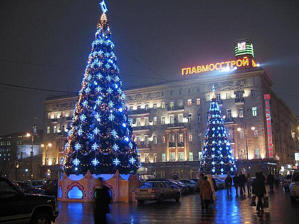
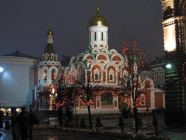
Christmas decorations in Moscow.
Christmas decorations in Moscow. • CIA World Factbook • 2020
The Cathedral of the Resurrection of Christ in Saint Petersburg - also known as the Church of the Savior on Spilled Blood - marks the location where Czar Alexander II was assasinated in 1881.
The Cathedral of the Resurrection of Christ in Saint Petersburg - also known as the Church of the Savior on Spilled Blood - marks the location where Czar Alexander II was assasinated in 1881. • CIA World Factbook • 2020
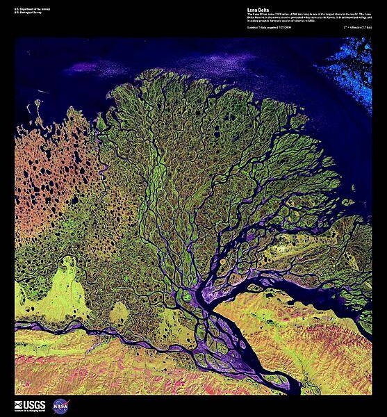
The Lena River, some 4,500 km (2,800 mi) long, is one of the longest rivers in the world. The Lena Delta Reserve, shown in this enhanced satellite photo, is the most extensive protected wilderness area in Russia; it serves as an important refuge and breeding ground for many species of Siberian wildlife. The wave-dominated delta of the Lena River is 30,000 sq km (11,580 sq mi) making it one of the largest of its kind in the world. Image courtesy of USGS.
The Lena River, some 4,500 km (2,800 mi) long, is one of the longest rivers in the world. The Lena Delta Reserve, shown in this enhanced satellite photo, is the most extensive protected wilderness area in Russia; it serves as an important refuge and breeding ground for many species of Siberian wildlife. The wave-dominated delta of the Lena River is 30,000 sq km (11,580 sq mi) making it one of the largest of its kind in the world. Image courtesy of USGS. • CIA World Factbook • 2020
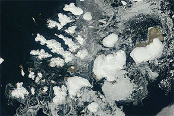
Russia’s northernmost territory, Franz Josef Land, is an archipelago of 191 islands in the northeastern Barents Sea. On 17 August 2011, clear skies allowed NASA’s Terra satellite this unobstructed view. Clouds fringe this natural-color scene, like curtains held back from a window. Around the islands, sea ice forms serpentine shapes of light gray and dull white. The glaciers that cap many of the islands are bright white. In ice-free areas, land cover is pale brown, typical of tundra. Situated about 1,000 km (625 mi) from the North Pole, Franz Josef Land has a punishing climate. The average summertime temperature is just 2 degrees Celsius (35 degrees Fahrenheit), and the average wintertime temperature is -22 degrees Celsius (-8 degrees Fahrenheit). Vegetation includes lichens, mosses, and Arctic flowering plants. Image courtesy of NASA/Jeff Schmaltz.
Russia’s northernmost territory, Franz Josef Land, is an archipelago of 191 islands in the northeastern Barents Sea. On 17 August 2011, clear skies allowed NASA’s Terra satellite this unobstructed view. Clouds fringe this natural-color scene, like curtains held back from a window. Around the islands, sea ice forms serpentine shapes of light gray and dull white. The glaciers that cap many of the islands are bright white. In ice-free areas, land cover is pale brown, typical of tundra.
Situated about 1,000 km (625 mi) from the North Pole, Franz Josef Land has a punishing climate. The average summertime temperature is just 2 degrees Celsius (35 degrees Fahrenheit), and the average wintertime temperature is -22 degrees Celsius (-8 degrees Fahrenheit). Vegetation includes lichens, mosses, and Arctic flowering plants. Image courtesy of NASA/Jeff Schmaltz. • CIA World Factbook • 2020
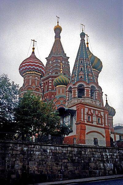
The Cathedral of Saint Basil the Blessed in Moscow is more formally known as the Cathedral of Intercession of Theotokas on the Moat. This Russian Orthodox church, located in Red Square, was erected in 1555-61 to commemorate the capture of Kazan and Astrakhan; it is located in the exact geometric center of the city. Since 1928 it has operated as a division of the State Historical Museum. The church was totally secularized in 1929; it is part of the Moscow Kremlin and Red Square UNESCO World Heritage site.
The Cathedral of Saint Basil the Blessed in Moscow is more formally known as the Cathedral of Intercession of Theotokas on the Moat. This Russian Orthodox church, located in Red Square, was erected in 1555-61 to commemorate the capture of Kazan and Astrakhan; it is located in the exact geometric center of the city. Since 1928 it has operated as a division of the State Historical Museum. The church was totally secularized in 1929; it is part of the Moscow Kremlin and Red Square UNESCO World Heritage site. • CIA World Factbook • 2020

CIA World Factbook • 2020
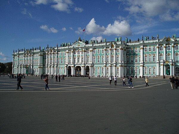
The former imperial Winter Palace in Saint Petersburg is now part of the Hermitage Museum.
The former imperial Winter Palace in Saint Petersburg is now part of the Hermitage Museum. • CIA World Factbook • 2020
CIA World Factbook • 2020

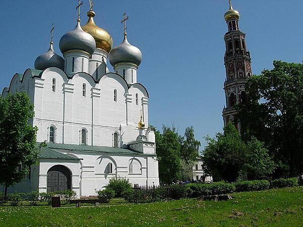
The Cathedral of Our Lady of Smolensk and its octagonal bell tower at the Novodevichy Convent in Moscow. Founded in 1524 to commemorate the capture of Smolensk from Lithuania, it became a convent for ladies of noble birth and was also used for a prison for female royals. Most of the current cathedral dates to the mid-17th century. After the Russian Revolution, the convent was turned into a museum. It was returned to the Russian Orthodox Church after World War II.
The Cathedral of Our Lady of Smolensk and its octagonal bell tower at the Novodevichy Convent in Moscow. Founded in 1524 to commemorate the capture of Smolensk from Lithuania, it became a convent for ladies of noble birth and was also used for a prison for female royals. Most of the current cathedral dates to the mid-17th century. After the Russian Revolution, the convent was turned into a museum. It was returned to the Russian Orthodox Church after World War II. • CIA World Factbook • 2020
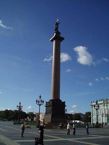
The Alexander Column is a focal point of Palace Square in Saint Petersburg (part of the Winter Palace appears in the background). The single-piece red granite column was erected between 1830 and 1834 in grateful commemoration of Czar Alexander I who led the Russian victory in the war with Napoleonic France. The monument - the tallest of its kind in the world - is 47.5 m (156 ft) high and weighs some 600 tons.
The Alexander Column is a focal point of Palace Square in Saint Petersburg (part of the Winter Palace appears in the background). The single-piece red granite column was erected between 1830 and 1834 in grateful commemoration of Czar Alexander I who led the Russian victory in the war with Napoleonic France. The monument - the tallest of its kind in the world - is 47.5 m (156 ft) high and weighs some 600 tons. • CIA World Factbook • 2020
The eastern side of the Kamchatka Peninsula juts into the Pacific Ocean west of Alaska in this enhanced winter satellite image. Snow-covered peaks and valley glaciers feed blue ice into coastal waters. The Kamchatka Peninsula is home to 160 volcanoes, 29 of which are active. The Volcanoes of Kamtchaka together form a UNESCO World Heritage Site. For other active volcanoes in Russia, see the Natural hazards-volcanism subfield in the Geography section. Image courtesy of USGS.
The eastern side of the Kamchatka Peninsula juts into the Pacific Ocean west of Alaska in this enhanced winter satellite image. Snow-covered peaks and valley glaciers feed blue ice into coastal waters. The Kamchatka Peninsula is home to 160 volcanoes, 29 of which are active. The Volcanoes of Kamtchaka together form a UNESCO World Heritage Site. For other active volcanoes in Russia, see the Natural hazards-volcanism subfield in the Geography section. Image courtesy of USGS. • CIA World Factbook • 2020
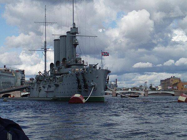
The Cruiser Aurora anchored in Saint Petersburg Harbor. It was a blank shot fired from this ship that signaled the assault on the Winter Palace and launched the October 1917 Revolution.
The Cruiser Aurora anchored in Saint Petersburg Harbor. It was a blank shot fired from this ship that signaled the assault on the Winter Palace and launched the October 1917 Revolution. • CIA World Factbook • 2020
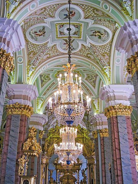
Pastel colors highlight the central nave of the Saints Peter and Paul Cathedral in Saint Petersburg. The Cathedral is located inside the Peter and Paul Fortress and houses the remains of almost all Russian emperors (and empresses) from Peter I to Nicholas II.
Pastel colors highlight the central nave of the Saints Peter and Paul Cathedral in Saint Petersburg. The Cathedral is located inside the Peter and Paul Fortress and houses the remains of almost all Russian emperors (and empresses) from Peter I to Nicholas II. • CIA World Factbook • 2020
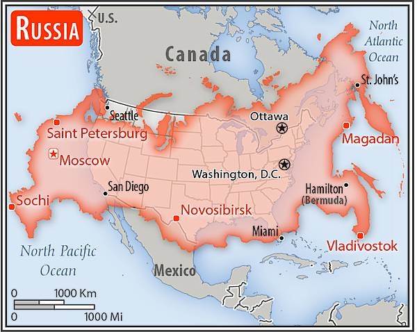
Area comparison map
Area comparison map • CIA World Factbook • 2020
CIA World Factbook • 2020
The Kazan Cathedral is a Russian Orthodox church located in the northeast corner of Red Square in Moscow. Originally constructed in 1636, the structure was destroyed in 1936 by the Soviet Government. It was rebuilt between 1990 and 1993 using detailed measurements and photos that had been preserved of the original church.
The Kazan Cathedral is a Russian Orthodox church located in the northeast corner of Red Square in Moscow. Originally constructed in 1636, the structure was destroyed in 1936 by the Soviet Government. It was rebuilt between 1990 and 1993 using detailed measurements and photos that had been preserved of the original church. • CIA World Factbook • 2020
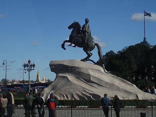
The Bronze Horseman - an equestrian statue of Peter I in Saint Petersburg - has become a symbol of the city.
The Bronze Horseman - an equestrian statue of Peter I in Saint Petersburg - has become a symbol of the city. • CIA World Factbook • 2020
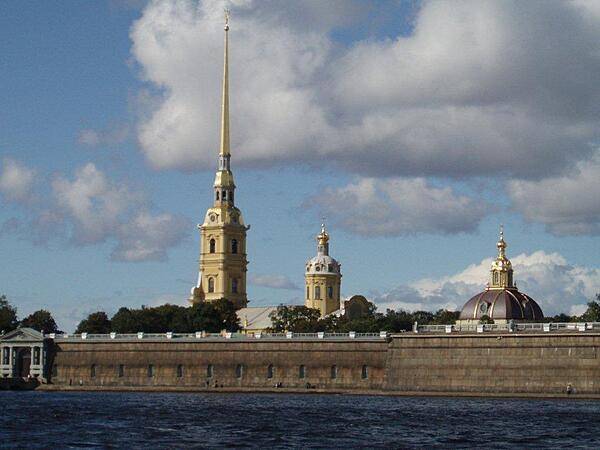
The Peter and Paul Fortress in Saint Petersburg - built between 1706 and 1740 - surrounds the Saints Peter and Paul Cathedral (completed 1733), which houses the remains of almost all of the members of the Russian imperial family.
The Peter and Paul Fortress in Saint Petersburg - built between 1706 and 1740 - surrounds the Saints Peter and Paul Cathedral (completed 1733), which houses the remains of almost all of the members of the Russian imperial family. • CIA World Factbook • 2020
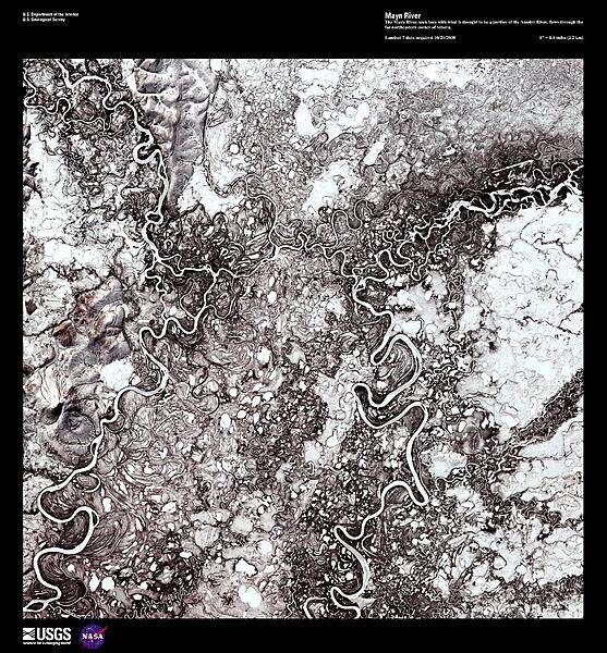
The Mayn River (on the left), seen here in a false color satellite image with a portion of the Anadyr River (on the right), flows through the far northeastern corner of Siberia. Both rivers carry a great deal of sediment and over time have created an amazing number of oxbow lakes. In this forest-tundra zone, both rivers remain frozen for 8 to 9 months out of the year. Image courtesy of USGS.
The Mayn River (on the left), seen here in a false color satellite image with a portion of the Anadyr River (on the right), flows through the far northeastern corner of Siberia. Both rivers carry a great deal of sediment and over time have created an amazing number of oxbow lakes. In this forest-tundra zone, both rivers remain frozen for 8 to 9 months out of the year. Image courtesy of USGS. • CIA World Factbook • 2020
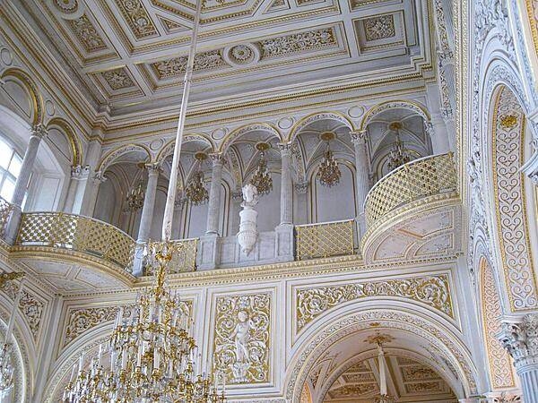
Some of the beautiful architecture found in the interior of the Hermitage Museum in Saint Petersburg. Located on the River Neva, the museum occupies six buildings and reputedly houses 3 million works of art.
Some of the beautiful architecture found in the interior of the Hermitage Museum in Saint Petersburg. Located on the River Neva, the museum occupies six buildings and reputedly houses 3 million works of art. • CIA World Factbook • 2020
CIA World Factbook • 2020
Media source: CIA World Factbook (2020) — Public Domain