›››
Turkiye
Turkiye
Population
85.5M
Rank #18Source: World Bank
Capital
Ankara
Source: REST Countries
Region
Europe
Europe & Central Asia
Source: REST Countries
GDP (Nominal)
$1.36T
Rank #17Source: World Bank
Land Area
783.6K km²
Rank #37Source: REST Countries
Life Expectancy
77.156 yrs
Source: World Bank
Historical Trends
Population Trend (5-Year)
Source: World Bank
GDP Trend (5-Year, Nominal USD)
Source: World Bank
Geography
Area: 783,562 km²
Landlocked: No
Independent: Yes
Climate: temperate; hot, dry summers with mild, wet winters; harsher in interior
Terrain: high central plateau (Anatolia); narrow coastal plain; several mountain ranges
Elevation: mean elevation: 1,132 m lowest point: Mediterranean Sea 0 m highest point: Mount Ararat 5,137 m
Natural Hazards: severe earthquakes, especially in northern Turkey, along an arc extending from the Sea of Marmara to Lake Van; landslides; floodingvolcanism: limited volcanic activity; its three historically active...
Environmental Issues: water pollution from dumping of chemicals and detergents; air pollution, particularly in urban areas; deforestation; land degradation; concern for oil spills from increasing Bosporus ship traffic;...
Land Use: agricultural land: 49.7% (2011 est.) forest: 14.9% (2011 est.) other: 35.4% (2011 est.)
Geography Note: strategic location controlling the Turkish Straits (Bosporus, Sea of Marmara, Dardanelles) that link the Black and Aegean Seas; the 3% of Turkish territory north of the Straits lies in Europe and...
Natural Resources
coaliron orecopperchromiumantimonymercurygoldbariteboratecelestite (strontium)
People & Society
Fertility Rate
1.51
Population
85.5M
Ethnic Groups
Kurdish (19%)
Religions
Muslim (99.8%)other (0.2%)
Economy
GDP per Capita
$15,892.716
GDP per Capita PPP
45,639.019
(2024)
(2024)
GNI per Capita
13,460
(2024)
(2024)
Gini Index
44.5
(2022)
(2022)
Unemployment
8.8%
(2024)
(2024)
Inflation
58.506%
(2024)
(2024)
Public Debt
26.619%
(2024)
(2024)
Energy
Electricity Access
100%
(2023)
(2023)
Renewable Energy
12%
(2021)
(2021)
CO₂ Emissions
460.028 Mt
(2024)
(2024)
Energy Intensity
2.27 MJ/$
(2022)
(2022)
Renewable Electricity
35.419%
(2021)
(2021)
Environment
Forest Coverage
29.48% of land
(2023)
(2023)
Communications
Internet Users
87.308%
(2024)
(2024)
Mobile Penetration
105.684%
(2023)
(2023)
Broadband Subscribers
22.459%
(2023)
(2023)
Transportation
Air Transport Freight
8,367.298 M ton-km
(2023)
(2023)
Container Port Traffic
12,366,172 TEU
(2022)
(2022)
Airports
810,474
Rail Lines
10,546 km
Roads Total
261,156 km(©IRF)
Military
Military Forces
Turkish Armed Forces (TSK): Turkish Land Forces (Turk Kara Kuvvetleri), Turkish Naval Forces (Turk Deniz Kuvvetleri; includes naval air and naval infantry), Turkish Air Forces (Turk Hava Kuvvetleri);...
Personnel Strength
size assessments for the Turkish Armed Forces (TSK) vary; approximately 375,000 total active duty personnel (280,000 Army; 45,000 Navy; 50,000 Air Force); approximately 150,000 Gendarmerie
Military Expenditure (USD)
$24.98B
Military Expenditure (% of GDP)
1.92%
Military Expenditure History
1.89% of GDP (2019 est.) 1.85% of GDP (2018) 1.52% of GDP (2017) 1.46% of GDP (2016) 1.39% of GDP (2015)
Deployments
600 Afghanistan (NATO); 250 Bosnia-Herzegovina (EUFOR); est. 25-35,000 Cyprus; 300 Kosovo (NATO); 170 Lebanon (UNIFIL); est. 200 Qatar; est. 200 Somalia (training mission); est. 5-10,000 Syria (2020)...
Equipment & Inventories
the Turkish Armed Forces inventory is mostly comprised of a mix of domestically-produced and Western weapons systems, although in recent years, Turkey has also acquired some Chinese, Russian, and...
Service Age & Obligation
President Erdoğan on 25 June 2019 signed a new law cutting the men’s mandatory military service period in half, as well as making paid military service permanent; with the new system, the period of...
Education
Pre-Primary Enrollment
39.746%
(2020)
(2020)
Primary Enrollment
102.488%
(2022)
(2022)
Secondary Enrollment
116.04%
(2022)
(2022)
Tertiary Enrollment
127.578%
(2022)
(2022)
Education Spending
3.096% of GDP
(2022)
(2022)
Adult Literacy Rate
97.26%
(2021)
(2021)
Pupil-Teacher Ratio
16.978:1
(2017)
(2017)
Health
Physicians per 1,000
2.236
(2022)
(2022)
Safe Water Access
95.987%
(2024)
(2024)
Safe Drinking Water
Not Available
Under-5 Mortality
12.8 per 1,000
(2023)
(2023)
Maternal Mortality (World Bank)
17.422 per 100,000
(2021)
(2021)
Hospital Beds per 1,000
75.272
(2021)
(2021)
UHC Coverage Index
77
(2023)
(2023)
Measles Immunization
99%
(2024)
(2024)
Social Indicators
Extreme Poverty Rate
0.5%
(2022)
(2022)
Food Insecurity
2.5%
(2023)
(2023)
Youth NEET Rate
16.298%
(2024)
(2024)
Governance
Women in Government
19.866%
(2024)
(2024)
Voice & Accountability
-0.86
(Below Average)
(2023)
(Below Average)
(2023)
Political Stability
-1.01
(Weak)
(2023)
(Weak)
(2023)
Government Effectiveness
-0.25
(Below Average)
(2023)
(Below Average)
(2023)
Regulatory Quality
-0.23
(Below Average)
(2023)
(Below Average)
(2023)
Rule of Law
-0.51
(Below Average)
(2023)
(Below Average)
(2023)
Control of Corruption
-0.50
(Below Average)
(2023)
(Below Average)
(2023)
Government
Government Type
presidential republic
Legal System
civil law system based on various European legal systems, notably the Swiss civil code
Executive Branch
chief of state: President Recep Tayyip ERDOGAN (chief of state since 28 August 2014; head of government since 9 July 2019); Vice President Fuat OKTAY (since 9 July 2018); note - the president is both...
Legislative Branch
description: unicameral Grand National Assembly of Turkey or Turkiye Buyuk Millet Meclisi (600 seats - increased from 550 seats beginning with June 2018 election; members directly elected in...
Judicial Branch
highest courts: Constitutional Court or Anayasa Mahkemesi (consists of the president, 2 vice presidents, and 12 judges); Court of Cassation (consists of about 390 judges and is organized into civil...
International Organizations
National Symbols
Flag Description
red with a vertical white crescent moon (the closed portion is toward the hoist side) and white five-pointed star centered just outside the crescent opening; the flag colors and designs closely...
National Symbols
vertical crescent moon with adjacent five-pointed star; national colors: red, white
National Anthem
name: "Istiklal Marsi" (Independence March) lyrics/music: Mehmet Akif ERSOY/Zeki UNGOR note: lyrics adopted 1921, music adopted 1932; the anthem's original music was adopted in 1924; a new...
Safety
Homicide Rate
3.228 per 100,000
(2023)
(2023)
Travel Information
Language(s): Turkish
Currency: TRY (₺)
Timezone(s): UTC+03:00
Landlocked: No
Independent: Yes
Driving Side: Right
Calling Code: +90
Car Sign: TR
Week Starts: Monday
Photos
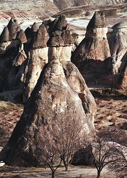
"Fairy chimneys" create a surreal landscape in the Cappadocia region of Turkey. Created by volcanic eruptions and shaped by centuries of wind and rain erosion, each of these structures consists of a soft cone topped by a layer of harder rock. They reach heights of up to 40 m (130 ft).
"Fairy chimneys" create a surreal landscape in the Cappadocia region of Turkey. Created by volcanic eruptions and shaped by centuries of wind and rain erosion, each of these structures consists of a soft cone topped by a layer of harder rock. They reach heights of up to 40 m (130 ft). • CIA World Factbook • 2020
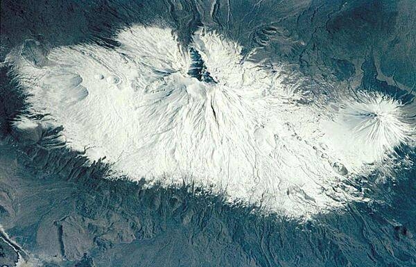
Mount Ararat (5,166 m, 16,949 ft) is the largest volcano in Turkey, but is not currently active. It is located in extreme northeastern Turkey, near the borders with Iran and Armenia. Southwest of the main peak lies Lesser Ararat (3,896 m, 12,877 ft). Ahora Gorge is a northeast-trending chasm dropping from the top of the mountain. Claims by different explorers to have found remnants of Noah's Ark on Mount Ararat have led to continuing expeditions to the mountain, many focusing their searches on the gorge area. Photo courtesy of NASA.
Mount Ararat (5,166 m, 16,949 ft) is the largest volcano in Turkey, but is not currently active. It is located in extreme northeastern Turkey, near the borders with Iran and Armenia. Southwest of the main peak lies Lesser Ararat (3,896 m, 12,877 ft). Ahora Gorge is a northeast-trending chasm dropping from the top of the mountain. Claims by different explorers to have found remnants of Noah's Ark on Mount Ararat have led to continuing expeditions to the mountain, many focusing their searches on the gorge area. Photo courtesy of NASA. • CIA World Factbook • 2020
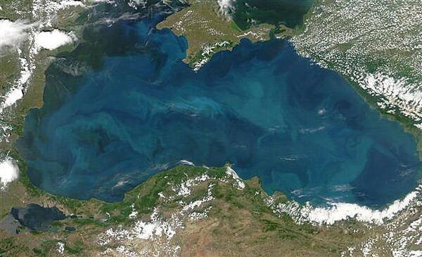
Swirls of color ranging from deep olive green to bright turquoise were created by a massive phytoplankton bloom that covered the entire surface of the Black Sea on this image taken 20 June 2006. Many of Europe's largest rivers, including the Danube, the Dnister, and the Dnipro (Dnieper) dump fresh water into the sea. The sea's only source of salty water is the narrow Bosporus Strait (in the southwest), which connects it to the Mediterranean Sea through the Sea of Marmara. Northern Turkey makes up the southern shore of the sea. The diamond-shaped landmass that projects into the sea from the north is Ukraine's Crimean peninsula. Photo courtesy of NASA.
Swirls of color ranging from deep olive green to bright turquoise were created by a massive phytoplankton bloom that covered the entire surface of the Black Sea on this image taken 20 June 2006. Many of Europe's largest rivers, including the Danube, the Dnister, and the Dnipro (Dnieper) dump fresh water into the sea. The sea's only source of salty water is the narrow Bosporus Strait (in the southwest), which connects it to the Mediterranean Sea through the Sea of Marmara. Northern Turkey makes up the southern shore of the sea. The diamond-shaped landmass that projects into the sea from the north is Ukraine's Crimean peninsula. Photo courtesy of NASA. • CIA World Factbook • 2020
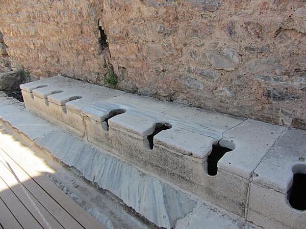
The public toilets in Ephesus were located in the public baths and had running water. Servants were often employed as seat warmers before the patrons used the cold stone seats. An inscription on a wall reads: "Close your eyes, count slowly to 10, and it will come."
The public toilets in Ephesus were located in the public baths and had running water. Servants were often employed as seat warmers before the patrons used the cold stone seats. An inscription on a wall reads: "Close your eyes, count slowly to 10, and it will come." • CIA World Factbook • 2020
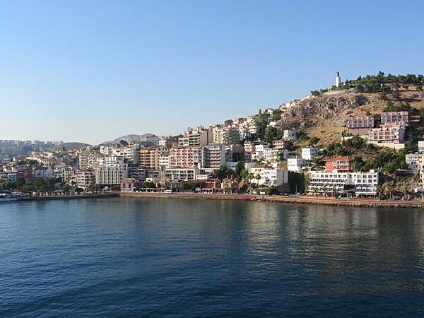
View of the port of Kusadasi on the Aegean Sea. The name Kusadasi means "Bird Island." In Byzantine times it was called "Ephesus Neopolis" and "Scala Nova" under the Genoese and Venetians. Its current name was officially adopted at the beginning of the 20th century by Turkish authorities. Kusadasi is the gateway to the Roman ruins at Ephesus. Some 95 km (57 mi) south of Izmir, it has grown since the late 1970s from a fishing village into a major tourist center serving thousands of tourists. A statue of Kemal Ataturk, the first president of Turkey and the founder of the Turkish Republic, stands on a hill overlooking the city.
View of the port of Kusadasi on the Aegean Sea. The name Kusadasi means "Bird Island." In Byzantine times it was called "Ephesus Neopolis" and "Scala Nova" under the Genoese and Venetians. Its current name was officially adopted at the beginning of the 20th century by Turkish authorities. Kusadasi is the gateway to the Roman ruins at Ephesus. Some 95 km (57 mi) south of Izmir, it has grown since the late 1970s from a fishing village into a major tourist center serving thousands of tourists. A statue of Kemal Ataturk, the first president of Turkey and the founder of the Turkish Republic, stands on a hill overlooking the city. • CIA World Factbook • 2020
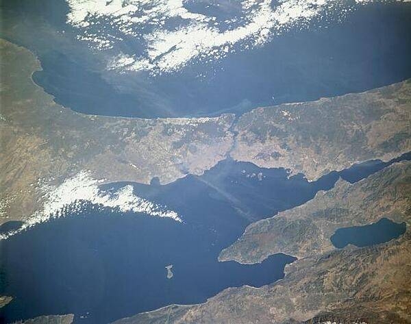
The Bosporus (near the center of the photograph), a strait that connects the Black Sea to the north with the Sea of Marmara to the south, stands out in this low-oblique, north-looking photograph. One of the world's most strategic waterways, the strait separates European Turkey to the west with Asiatic Turkey to the east. Istanbul (formerly Constantinople), one of the great historic cities of the world, sits near the Bosporus entrance to the Sea of Marmara. Photo courtesy of NASA.
The Bosporus (near the center of the photograph), a strait that connects the Black Sea to the north with the Sea of Marmara to the south, stands out in this low-oblique, north-looking photograph. One of the world's most strategic waterways, the strait separates European Turkey to the west with Asiatic Turkey to the east. Istanbul (formerly Constantinople), one of the great historic cities of the world, sits near the Bosporus entrance to the Sea of Marmara. Photo courtesy of NASA. • CIA World Factbook • 2020
60 photos available
View All Photos→Data sources: World Bank, UN Data • Updated daily •Learn about our data