›››
Ukraine
Ukraine
Population
37.9M
Rank #41Source: World Bank
Capital
Kiev
Source: REST Countries
Region
Europe
Europe & Central Asia
Source: REST Countries
GDP (Nominal)
$190.74B
Rank #57Source: World Bank
Land Area
603.5K km²
Rank #45Source: REST Countries
Life Expectancy
73.422 yrs
Source: World Bank
Historical Trends
Population Trend (5-Year)
Source: World Bank
GDP Trend (5-Year, Nominal USD)
Source: World Bank
Geography
Area: 603,550 km²
Landlocked: No
Independent: Yes
Climate: temperate continental; Mediterranean only on the southern Crimean coast; precipitation disproportionately distributed, highest in west and north, lesser in east and southeast; winters vary from cool...
Terrain: mostly fertile plains (steppes) and plateaus, with mountains found only in the west (the Carpathians) or in the extreme south of the Crimean Peninsula
Elevation: mean elevation: 175 m lowest point: Black Sea 0 m highest point: Hora Hoverla 2,061 m
Natural Hazards: occasional floods; occasional droughts
Environmental Issues: air and water pollution; land degradation; solid waste management; biodiversity loss; deforestation; radiation contamination in the northeast from 1986 accident at Chornobyl' Nuclear Power Plant
Land Use: agricultural land: 71.2% (2011 est.) forest: 16.8% (2011 est.) other: 12% (2011 est.)
Geography Note: strategic position at the crossroads between Europe and Asia; second-largest country in Europe after Russia
Natural Resources
iron orecoalmanganesenatural gasoilsaltsulfurgraphitetitaniummagnesium
People & Society
Fertility Rate
0.98
Population
37.9M
Ethnic Groups
Ukrainian (77.8%)Russian (17.3%)Belarusian (0.6%)Moldovan (0.5%)Crimean Tatar (0.5%)Bulgarian (0.4%)Hungarian (0.3%)Romanian (0.3%)Polish (0.3%)Jewish (0.2%)other (1.8%)
Religions
and the UAOC accounts for 1-2%; Muslim and Jewish adherents each compose less than (1%)
Economy
GDP per Capita
$5,389.473
GDP per Capita PPP
18,550.463
(2024)
(2024)
GNI per Capita
5,210
(2024)
(2024)
Gini Index
25.6
(2020)
(2020)
Unemployment
9.834%
(2021)
(2021)
Inflation
6.502%
(2024)
(2024)
Public Debt
58.716%
(2020)
(2020)
Energy
Electricity Access
100%
(2023)
(2023)
Renewable Energy
8.9%
(2021)
(2021)
CO₂ Emissions
118.478 Mt
(2024)
(2024)
Energy Intensity
6.89 MJ/$
(2021)
(2021)
Renewable Electricity
12.014%
(2021)
(2021)
Environment
Forest Coverage
16.755% of land
(2023)
(2023)
Communications
Internet Users
82.376%
(2023)
(2023)
Mobile Penetration
122.758%
(2023)
(2023)
Broadband Subscribers
19.675%
(2023)
(2023)
Transportation
Air Transport Freight
3.127 M ton-km
(2022)
(2022)
Container Port Traffic
1,022,376 TEU
(2021)
(2021)
Airports
4,910.333
Rail Lines
21,625.9 km
Roads Total
162,308.3 km(©IRF)
Military
Military Forces
Armed Forces of Ukraine (Zbroyni Syly Ukrayiny, ZSU): Ground Forces (Sukhoputni Viys’ka), Naval Forces (Viys’kovo-Mors’ki Syly, VMS), Air Forces (Povitryani Syly, PS), Air Assault Forces...
Personnel Strength
size estimates for the Armed Forces of Ukraine (Zbroyni Syly Ukrayiny, ZSU) vary; approximately 215,000 active troops (160,000 Army, including Airborne/Air Assault Forces; 13,000 Navy; 42,000 Air...
Military Expenditure (USD)
$64.70B
Military Expenditure (% of GDP)
34.48%
Military Expenditure History
3.9% of GDP (2019) 3.7% of GDP (2018) 2.9% of GDP (2017) 3.2% of GDP (2016) 3.3% of GDP (2015)
Deployments
250 Democratic Republic of the Congo (MONUSCO); contributes about 550 troops to the Lithuania, Poland, and Ukraine joint military brigade (LITPOLUKRBRIG), which was established in 2014; the brigade...
Equipment & Inventories
the Ukrainian military is equipped mostly with older Russian and Soviet-era weapons systems; since 2010, it has imported limited quantities of weapons from several European countries, as well as...
Service Age & Obligation
20-27 years of age for compulsory military service; conscript service obligation is 12 months
Education
Pre-Primary Enrollment
85.82%
(2020)
(2020)
Primary Enrollment
93.306%
(2024)
(2024)
Secondary Enrollment
84.652%
(2021)
(2021)
Tertiary Enrollment
85.267%
(2024)
(2024)
Education Spending
5.14% of GDP
(2021)
(2021)
Pupil-Teacher Ratio
12.98:1
(2018)
(2018)
Health
Physicians per 1,000
3.531
(2023)
(2023)
Safe Water Access
93.479%
(2024)
(2024)
Safe Drinking Water
87.868%
(2024)
(2024)
Under-5 Mortality
8.1 per 1,000
(2023)
(2023)
Maternal Mortality (World Bank)
19.59 per 100,000
(2021)
(2021)
Hospital Beds per 1,000
75.337
(2021)
(2021)
UHC Coverage Index
80
(2023)
(2023)
Measles Immunization
88%
(2024)
(2024)
Social Indicators
Extreme Poverty Rate
Not Available
Food Insecurity
6.9%
(2023)
(2023)
Youth NEET Rate
19.062%
(2021)
(2021)
Governance
Women in Government
21.092%
(2024)
(2024)
Voice & Accountability
-0.10
(Below Average)
(2023)
(Below Average)
(2023)
Political Stability
-1.43
(Weak)
(2023)
(Weak)
(2023)
Government Effectiveness
-0.36
(Below Average)
(2023)
(Below Average)
(2023)
Regulatory Quality
-0.27
(Below Average)
(2023)
(Below Average)
(2023)
Rule of Law
-0.89
(Below Average)
(2023)
(Below Average)
(2023)
Control of Corruption
-0.69
(Below Average)
(2023)
(Below Average)
(2023)
Government
Government Type
semi-presidential republic
Legal System
civil law system; judicial review of legislative acts
Executive Branch
chief of state: President Volodymyr ZELENSKYY (since 20 May 2019) head of government: Prime Minister Denys SHMYHAL (since 4 March 2020) cabinet: Cabinet of Ministers nominated by the prime minister,...
Legislative Branch
description: unicameral Supreme Council or Verkhovna Rada (450 seats; 225 members directly elected in single-seat constituencies by simple majority vote and 225 directly elected in a single...
Judicial Branch
highest courts: Supreme Court of Ukraine or SCU (consists of 100 judges, organized into civil, criminal, commercial and administrative chambers, and a grand chamber); Constitutional Court (consists...
National Symbols
Flag Description
two equal horizontal bands of azure (top) and golden yellow represent grain fields under a blue sky
National Symbols
tryzub (trident); national colors: blue, yellow
National Anthem
name: "Shche ne vmerla Ukraina" (Ukraine Has Not Yet Perished) lyrics/music: Paul CHUBYNSKYI/Mikhail VERBYTSKYI note: music adopted 1991, lyrics adopted 2003; song first performed in 1864 at the...
Safety
Homicide Rate
3.777 per 100,000
(2021)
(2021)
Travel Information
Language(s): Ukrainian
Currency: UAH (₴)
Timezone(s): UTC+02:00
Landlocked: No
Independent: Yes
Driving Side: Right
Calling Code: +380
Car Sign: UA
Week Starts: Monday
Photos
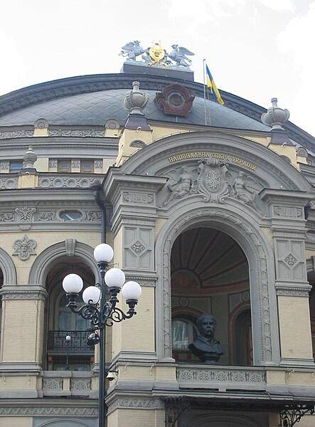
The National Opera House of Ukraine in Kyiv is named after Taras Shevchenko, Ukraine's most famous poet and artist. His bust sits in an alcove over the entranceway.
The National Opera House of Ukraine in Kyiv is named after Taras Shevchenko, Ukraine's most famous poet and artist. His bust sits in an alcove over the entranceway. • CIA World Factbook • 2020
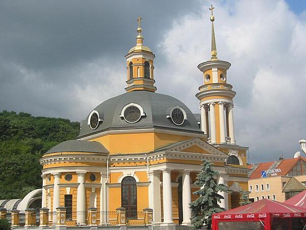
The Church of the Nativity was one of three Neoclassical churches in the Podil area of Kyiv that was destroyed by the Soviet Government in the 1930s. Originally constructed between 1809 and 1814, it was chiefly remembered as the church where the body of Taras Shevchenko, Ukraine's national bard, lay in state in 1861 while on its way to its final resting place in Kaniv. Torn down in 1935, the church was rebuilt in 2005.
The Church of the Nativity was one of three Neoclassical churches in the Podil area of Kyiv that was destroyed by the Soviet Government in the 1930s. Originally constructed between 1809 and 1814, it was chiefly remembered as the church where the body of Taras Shevchenko, Ukraine's national bard, lay in state in 1861 while on its way to its final resting place in Kaniv. Torn down in 1935, the church was rebuilt in 2005. • CIA World Factbook • 2020
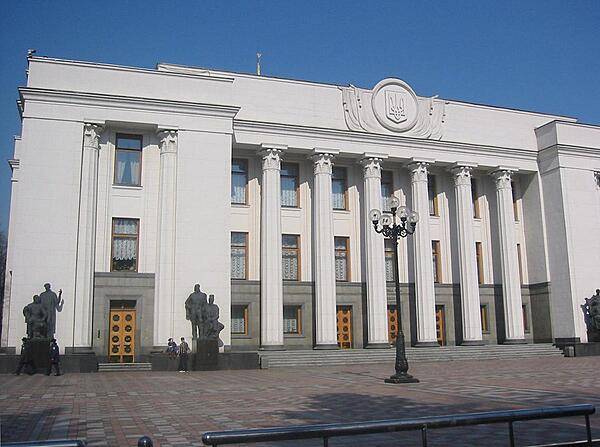
The Verkhovna Rada (Supreme Council) building in Kyiv is home to Ukraine's 450-member parliament.
The Verkhovna Rada (Supreme Council) building in Kyiv is home to Ukraine's 450-member parliament. • CIA World Factbook • 2020
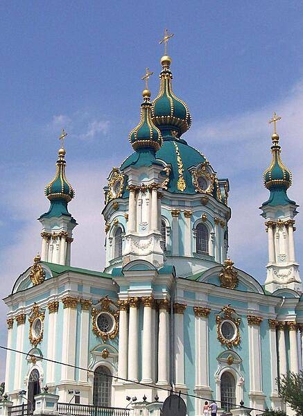
The Baroque Saint Andrew's Church in the Podil neighborhood of Kyiv was designed by the famous architect Bartolomeo Rastrelli and constructed between 1747 and 1754. It is reputed to stand on the site where in the first century A.D. Saint Andrew planted a cross and prophesied that a great Christian city would one day rise.
The Baroque Saint Andrew's Church in the Podil neighborhood of Kyiv was designed by the famous architect Bartolomeo Rastrelli and constructed between 1747 and 1754. It is reputed to stand on the site where in the first century A.D. Saint Andrew planted a cross and prophesied that a great Christian city would one day rise. • CIA World Factbook • 2020
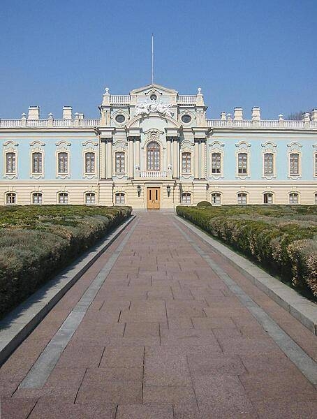
Approaching the Mariinsky Palace in Kyiv, the official ceremonial residence of the president of Ukraine. The palace is one of two magnificent Baroque buildings in Ukraine designed by the renowned architect Bartolomeo Rastrelli (the other is Saint Andrew's Church, in Kyiv).
Approaching the Mariinsky Palace in Kyiv, the official ceremonial residence of the president of Ukraine. The palace is one of two magnificent Baroque buildings in Ukraine designed by the renowned architect Bartolomeo Rastrelli (the other is Saint Andrew's Church, in Kyiv). • CIA World Factbook • 2020
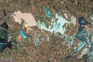
From mainland Ukraine, the Crimean Peninsula extends southward, bordered on the west by the Black Sea and on the east by the Sea of Azov. Stretching across the peninsula is a network of shallow, marshy inlets sprawling over roughly 2,600 sq km (1,000 sq mi). This network of lagoons is known as Syvash (also Sivash or Sivas). During the summer months, the warmed marsh waters give off unpleasant odors, lending the region the nicknames of "Rotten Sea" or "Putrid Sea." This natural-color satellite image shows the shallow waters and varied chemical composition of the Syvash lagoons contribute to their unearthly colors of peach, mustard, lime green, blue, blue-green, beige, and brown. Thick layers of silt coat the bottoms of the shallow marshes, which are rich enough in mineral salts to supply a local chemical plant. Surrounding the marshy areas are mostly agricultural fields. Urbanized areas appear along the shores of the Black Sea, and highways curve and zigzag across the peninsula. Outside of the marshes, the land in this area is generally a level plain of arid steppe. In colder months, frosts alternate with thaws, and fogs are frequent. Photo courtesy of NASA.
From mainland Ukraine, the Crimean Peninsula extends southward, bordered on the west by the Black Sea and on the east by the Sea of Azov. Stretching across the peninsula is a network of shallow, marshy inlets sprawling over roughly 2,600 sq km (1,000 sq mi). This network of lagoons is known as Syvash (also Sivash or Sivas). During the summer months, the warmed marsh waters give off unpleasant odors, lending the region the nicknames of "Rotten Sea" or "Putrid Sea."
This natural-color satellite image shows the shallow waters and varied chemical composition of the Syvash lagoons contribute to their unearthly colors of peach, mustard, lime green, blue, blue-green, beige, and brown. Thick layers of silt coat the bottoms of the shallow marshes, which are rich enough in mineral salts to supply a local chemical plant.
Surrounding the marshy areas are mostly agricultural fields. Urbanized areas appear along the shores of the Black Sea, and highways curve and zigzag across the peninsula. Outside of the marshes, the land in this area is generally a level plain of arid steppe. In colder months, frosts alternate with thaws, and fogs are frequent. Photo courtesy of NASA. • CIA World Factbook • 2020
40 photos available
View All Photos→Data sources: World Bank, UN Data • Updated daily •Learn about our data