›››
United States
United States
Population
340.1M
Rank #3Source: World Bank
Capital
Washington D.C.
Source: REST Countries
Region
Americas
North America
Source: REST Countries
GDP (Nominal)
$28.75T
Rank #1Source: World Bank
Land Area
9.5M km²
Rank #4Source: REST Countries
Life Expectancy
78.385 yrs
Source: World Bank
Historical Trends
Population Trend (5-Year)
Source: World Bank
GDP Trend (5-Year, Nominal USD)
Source: World Bank
Geography
Area: 9,525,067 km²
Landlocked: No
Independent: Yes
Climate: mostly temperate, but tropical in Hawaii and Florida, arctic in Alaska, semiarid in the great plains west of the Mississippi River, and arid in the Great Basin of the southwest; low winter...
Terrain: vast central plain, mountains in west, hills and low mountains in east; rugged mountains and broad river valleys in Alaska; rugged, volcanic topography in Hawaii
Elevation: mean elevation: 760 m lowest point: Death Valley (lowest point in North America) -86 m highest point: Denali 6,190 m (Mount McKinley) (highest point in North America) note: the peak of Mauna Kea...
Natural Hazards: tsunamis; volcanoes; earthquake activity around Pacific Basin; hurricanes along the Atlantic and Gulf of Mexico coasts; tornadoes in the Midwest and Southeast; mud slides in California; forest fires...
Environmental Issues: air pollution; large emitter of carbon dioxide from the burning of fossil fuels; water pollution from runoff of pesticides and fertilizers; limited natural freshwater resources in much of the western...
Land Use: agricultural land: 44.5% (2011 est.) forest: 33.3% (2011 est.) other: 22.2% (2011 est.)
Geography Note: note 1: world's third-largest country by size (after Russia and Canada) and by population (after China and India); Denali (Mt. McKinley) is the highest point in North America and Death Valley the...
Natural Resources
coalcopperleadmolybdenumphosphatesrare earth elementsuraniumbauxitegoldiron
People & Society
Fertility Rate
1.62
Population
340.1M
Ethnic Groups
White (72.4%)Black (12.6%)Asian (4.8%)Amerindian and Alaska native (0.9%)native Hawaiian and other Pacific islander (0.2%)other (6.2%)two or more races (2.9%)and Central or South American origin living in the US who may be of any race or ethnic group (white, black, Asian, etc.); an estimated (16.3%)
Religions
Protestant (46.5%)Roman Catholic (20.8%)Jewish (1.9%)Mormon (1.6%)other Christian (0.9%)Muslim (0.9%)Jehovah's Witness (0.8%)Buddhist (0.7%)Hindu (0.7%)other (1.8%)unaffiliated (22.8%)don't know/refused (0.6%)
Economy
GDP per Capita
$84,534.041
GDP per Capita PPP
85,809.9
(2024)
(2024)
GNI per Capita
83,490
(2024)
(2024)
Gini Index
41.8
(2023)
(2023)
Unemployment
4.022%
(2024)
(2024)
Inflation
2.95%
(2024)
(2024)
Public Debt
118.111%
(2024)
(2024)
Energy
Electricity Access
100%
(2023)
(2023)
Renewable Energy
10.9%
(2021)
(2021)
CO₂ Emissions
4,632.165 Mt
(2024)
(2024)
Energy Intensity
4.17 MJ/$
(2022)
(2022)
Renewable Electricity
20.273%
(2021)
(2021)
Environment
Forest Coverage
33.867% of land
(2023)
(2023)
Communications
Internet Users
93.144%
(2023)
(2023)
Mobile Penetration
112.411%
(2023)
(2023)
Broadband Subscribers
38.148%
(2023)
(2023)
Transportation
Air Transport Freight
42,762.859 M ton-km
(2023)
(2023)
Container Port Traffic
62,214,119 TEU
(2022)
(2022)
Airports
9,267,193
Rail Lines
148,553.347 km
Roads Total
6,645,582.066 km(©IRF)
Military
Military Forces
United States Armed Forces: US Army, US Navy (includes Marine Corps), US Air Force, US Space Force; US Coast Guard (administered in peacetime by the Department of Homeland Security, but in wartime...
Personnel Strength
the US Armed Forces have approximately 1.372 million active duty personnel (475,000 Army; 340,000 Navy; 330,000 Air Force; 185,000 Marine Corps); 42,000 Coast Guard; 335,000 Army National Guard;...
Military Expenditure (USD)
$997.31B
Military Expenditure (% of GDP)
3.42%
Military Expenditure History
3.42% of GDP (2019 est.) 3.3% of GDP (2018) 3.31% of GDP (2017) 3.52% of GDP (2016) 3.52% of GDP (2015)
Deployments
4,500 Afghanistan (NATO; note - the US has pledged to further reduce the number of troops in Afghanistan by the end of 2020); 5,000 Africa (mostly in Djibouti with approximately 700 in Somalia and...
Equipment & Inventories
the US military's inventory is comprised almost entirely of domestically-produced weapons systems (some assembled with foreign components) along with a smaller mix of imported equipment from a...
Service Age & Obligation
18 years of age (17 years of age with parental consent) for male and female voluntary service; no conscription; maximum enlistment age 34 (Army), 39 (Air Force), 39 (Navy), 28 (Marines), 31 (Coast...
Education
Pre-Primary Enrollment
72.396%
(2020)
(2020)
Primary Enrollment
96.972%
(2022)
(2022)
Secondary Enrollment
97.473%
(2022)
(2022)
Tertiary Enrollment
79.362%
(2022)
(2022)
Education Spending
5.42% of GDP
(2021)
(2021)
Pupil-Teacher Ratio
14.199:1
(2017)
(2017)
Health
Physicians per 1,000
3.681
(2022)
(2022)
Safe Water Access
99.98%
(2024)
(2024)
Safe Drinking Water
97.568%
(2024)
(2024)
Under-5 Mortality
6.5 per 1,000
(2023)
(2023)
Maternal Mortality (World Bank)
20.577 per 100,000
(2021)
(2021)
Hospital Beds per 1,000
79.147
(2021)
(2021)
UHC Coverage Index
88
(2023)
(2023)
Measles Immunization
94%
(2024)
(2024)
Social Indicators
Extreme Poverty Rate
1.2%
(2023)
(2023)
Food Insecurity
2.5%
(2023)
(2023)
Youth NEET Rate
8.929%
(2024)
(2024)
Governance
Women in Government
28.736%
(2024)
(2024)
Voice & Accountability
0.88
(Above Average)
(2023)
(Above Average)
(2023)
Political Stability
0.03
(Above Average)
(2023)
(Above Average)
(2023)
Government Effectiveness
1.22
(Strong)
(2023)
(Strong)
(2023)
Regulatory Quality
1.39
(Strong)
(2023)
(Strong)
(2023)
Rule of Law
1.33
(Strong)
(2023)
(Strong)
(2023)
Control of Corruption
1.12
(Strong)
(2023)
(Strong)
(2023)
Government
Government Type
constitutional federal republic
Legal System
common law system based on English common law at the federal level; state legal systems based on common law, except Louisiana, where state law is based on Napoleonic civil code; judicial review of...
Executive Branch
chief of state: President Donald J. TRUMP (since 20 January 2017); Vice President Michael R. PENCE (since 20 January 2017); note - the president is both chief of state and head of government head of...
Legislative Branch
description: bicameral Congress consists of:Senate (100 seats; 2 members directly elected in each of the 50 state constituencies by simple majority vote except in Georgia and Louisiana which require...
Judicial Branch
highest courts: US Supreme Court (consists of 9 justices - the chief justice and 8 associate justices) judge selection and term of office: president nominates and, with the advice and consent of the...
International Organizations
ADB (nonregional member)AfDB (nonregional member)ANZUSAPECArctic CouncilARFASEAN (dialogue partner)Australia Group
National Symbols
Flag Description
13 equal horizontal stripes of red (top and bottom) alternating with white; there is a blue rectangle in the upper hoist-side corner bearing 50 small, white, five-pointed stars arranged in nine...
National Symbols
bald eagle; national colors: red, white, blue
National Anthem
name: The Star-Spangled Banner lyrics/music: Francis Scott KEY/John Stafford SMITH note: adopted 1931; during the War of 1812, after witnessing the successful American defense of Fort McHenry in...
Safety
Homicide Rate
5.763 per 100,000
(2023)
(2023)
Travel Information
Language(s): English
Currency: USD ($)
Timezone(s): UTC +10:00 to -12:00
Landlocked: No
Independent: Yes
Driving Side: Right
Calling Code: +1
Car Sign: USA
Week Starts: Sunday
Photos
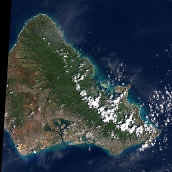
Oahu is the most populated of the Hawaiian Islands. Hawaii's capital of Honolulu stretches along its southern shore. Just to the east of Honolulu is Waikiki Beach, with throngs of tourists and dozens of high-rise hotels. Overlooking Waikiki is Diamond Head, a volcanic crater formed some 200,000 years ago (extinct for about 150,000 years). The clouds in the right hand corner of this image are an almost permanent feature of Oahu. Trade winds blowing from the northeast are stopped by the 960 m (3,000 ft) high mountain range, where they rain out most of their moisture. As a result, the windward side of Oahu is usually cloudy, and the leeward side is relatively clear and dry. The large indent in the lower left of the image is Pearl Harbor, site of the Japanese air raid which drew America into World War II. The harbor still serves as a US Navy base. Photo courtesy of NASA.
Oahu is the most populated of the Hawaiian Islands. Hawaii's capital of Honolulu stretches along its southern shore. Just to the east of Honolulu is Waikiki Beach, with throngs of tourists and dozens of high-rise hotels. Overlooking Waikiki is Diamond Head, a volcanic crater formed some 200,000 years ago (extinct for about 150,000 years). The clouds in the right hand corner of this image are an almost permanent feature of Oahu. Trade winds blowing from the northeast are stopped by the 960 m (3,000 ft) high mountain range, where they rain out most of their moisture. As a result, the windward side of Oahu is usually cloudy, and the leeward side is relatively clear and dry. The large indent in the lower left of the image is Pearl Harbor, site of the Japanese air raid which drew America into World War II. The harbor still serves as a US Navy base. Photo courtesy of NASA. • CIA World Factbook • 2020
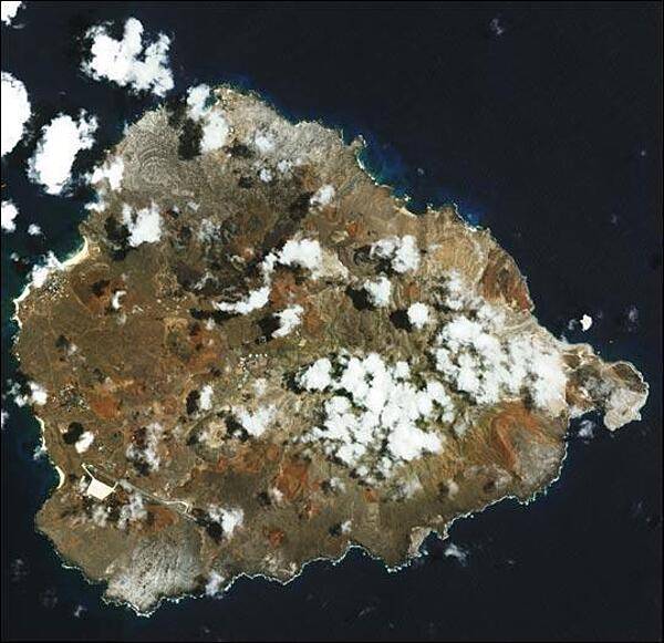
In the southern Atlantic Ocean roughly midway between central South America and central Africa, sits Ascension Island. A small, rocky, volcanic outcrop covered in many places by lava flows and cinder cones of dormant volcanoes, the island sits just west of the Mid-Atlantic Ridge. In this detailed satellite image taken 24 February 2003, marbled-looking lava flows can be seen dominating the northwest coast, with smaller flows visible on the southwest coast below the island's Wideawake Airfield, as well as on the southeast coast. Northeast of the airstrip, a large cinder cone is visible, its dark brown center fading to tan in a series of pale rings. This crater, the island's largest, is called Devil's Riding School. Crisp, white surf breaks along the shores. Image courtesy of NASA.
In the southern Atlantic Ocean roughly midway between central South America and central Africa, sits Ascension Island. A small, rocky, volcanic outcrop covered in many places by lava flows and cinder cones of dormant volcanoes, the island sits just west of the Mid-Atlantic Ridge. In this detailed satellite image taken 24 February 2003, marbled-looking lava flows can be seen dominating the northwest coast, with smaller flows visible on the southwest coast below the island's Wideawake Airfield, as well as on the southeast coast. Northeast of the airstrip, a large cinder cone is visible, its dark brown center fading to tan in a series of pale rings. This crater, the island's largest, is called Devil's Riding School. Crisp, white surf breaks along the shores. Image courtesy of NASA. • CIA World Factbook • 2020
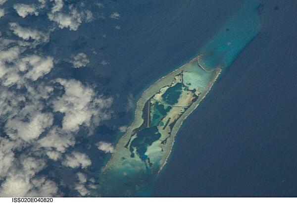
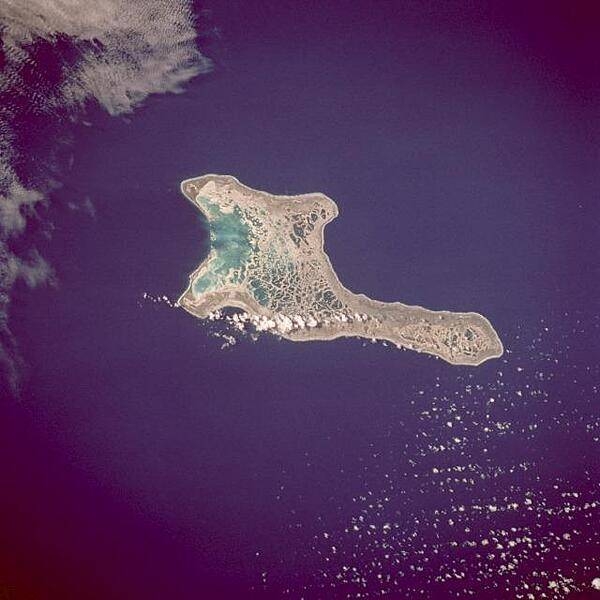
Palmyra Atoll is an unoccupied equatorial Northern Pacific atoll of some 12 sq km (4.6 sq mi) administered by the US Government. It is located almost due south of the Hawaiian Islands, roughly halfway between Hawaii and American Samoa. The atoll consists of an extensive reef, two shallow lagoons, and some 50 sand and reef-rock islets and bars covered with vegetation. The variable temporary population of 4 to 20 "non-occupants" consists of staff and scientists employed by various departments of the US Government and The Nature Conservancy, as well as a rotating mix of Palmyra Atoll Research Consortium scholars pursuing research. Photo courtesy of NASA.
Palmyra Atoll is an unoccupied equatorial Northern Pacific atoll of some 12 sq km (4.6 sq mi) administered by the US Government. It is located almost due south of the Hawaiian Islands, roughly halfway between Hawaii and American Samoa. The atoll consists of an extensive reef, two shallow lagoons, and some 50 sand and reef-rock islets and bars covered with vegetation. The variable temporary population of 4 to 20 "non-occupants" consists of staff and scientists employed by various departments of the US Government and The Nature Conservancy, as well as a rotating mix of Palmyra Atoll Research Consortium scholars pursuing research. Photo courtesy of NASA. • CIA World Factbook • 2020
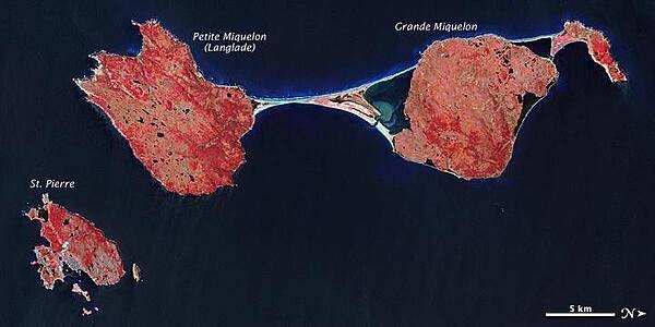
The last remnant of France's once-vast holdings in North America, this island archipelago off the coast of Newfoundland bears the scars of a complicated geologic history. Saint Pierre and Miquelon cover just 242 sq km (93 sq mi), and the three biggest islands lend the entire archipelago its name. In this false-color satellite image, vegetation appears in varying shades of pink and red, bare land is beige, urbanized areas are blue-gray, and water appears in shades of blue and blue-green. Saint Pierre is the smallest of the archipelago's major islands, a mostly northeast-southwest running landmass with several smaller islands and islets scattered around it. In the west (top of the image), Miquelon consists of three main sections: an arc-shaped body in the north (top right), Grande Miquelon immediately southeast of that, and Langlade (or Petite Miquelon) Island in the south. Grande Miquelon and Langlade are connected by a tombolo, a ridge of beach material (typically sand), built by wave action, that connects an island to the mainland. This tombolo formed in the eighteenth century. The terrain of the archipelago consists of mostly barren rock. Deforestation has claimed much of the vegetation, although woodland still covers 20 percent of the surface. Scrub vegetation and peatland are extensive. Cold, wet, foggy weather predominates, with windy springs and autumns. The islands, particularly Langlade, bear a scoured appearance, and this is no coincidence. During the Pleistocene Ice Age, glacial ice scraped the island. Today, wind and waves continue to erode these landmasses. For several months a year, winds regularly exceed 60 km (35 mi) per hour, and frequent storms pound the coastlines with high waves. Anecdotal evidence from local fishermen suggests that recent mild winters and less extensive sea ice might have allowed more erosion by ocean waves. Photo courtesy of NASA.
The last remnant of France's once-vast holdings in North America, this island archipelago off the coast of Newfoundland bears the scars of a complicated geologic history. Saint Pierre and Miquelon cover just 242 sq km (93 sq mi), and the three biggest islands lend the entire archipelago its name.
In this false-color satellite image, vegetation appears in varying shades of pink and red, bare land is beige, urbanized areas are blue-gray, and water appears in shades of blue and blue-green.
Saint Pierre is the smallest of the archipelago's major islands, a mostly northeast-southwest running landmass with several smaller islands and islets scattered around it. In the west (top of the image), Miquelon consists of three main sections: an arc-shaped body in the north (top right), Grande Miquelon immediately southeast of that, and Langlade (or Petite Miquelon) Island in the south. Grande Miquelon and Langlade are connected by a tombolo, a ridge of beach material (typically sand), built by wave action, that connects an island to the mainland. This tombolo formed in the eighteenth century.
The terrain of the archipelago consists of mostly barren rock. Deforestation has claimed much of the vegetation, although woodland still covers 20 percent of the surface. Scrub vegetation and peatland are extensive. Cold, wet, foggy weather predominates, with windy springs and autumns.
The islands, particularly Langlade, bear a scoured appearance, and this is no coincidence. During the Pleistocene Ice Age, glacial ice scraped the island. Today, wind and waves continue to erode these landmasses. For several months a year, winds regularly exceed 60 km (35 mi) per hour, and frequent storms pound the coastlines with high waves. Anecdotal evidence from local fishermen suggests that recent mild winters and less extensive sea ice might have allowed more erosion by ocean waves. Photo courtesy of NASA. • CIA World Factbook • 2020
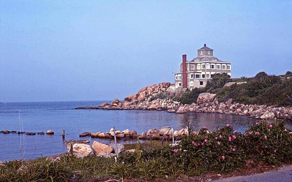
Seaside view at Gloucester, Massacusetts. Settled in 1623, the city - long a fishing and seafood center - claims to be America's oldest seaport.
Seaside view at Gloucester, Massacusetts. Settled in 1623, the city - long a fishing and seafood center - claims to be America's oldest seaport. • CIA World Factbook • 2020
Kiritimati Island (formerly Christmas Island), the largest atoll in the Pacific Ocean, is the centerpiece of this low-oblique, northeast-looking photo. The atoll covers 606 sq km (234 sq mi), of which 243 sq km (94 sq mi) are land. The island was discovered by Captain James Cook in 1777. The majority of the island's inhabitants work on coconut plantations and in copra production. The island's major airbase is on the northeast side of the island. Nuclear tests were conducted on Kiritimati Island by the British in 1957 and 1958 and by the United States in 1962. Image courtesy of NASA.
Kiritimati Island (formerly Christmas Island), the largest atoll in the Pacific Ocean, is the centerpiece of this low-oblique, northeast-looking photo. The atoll covers 606 sq km (234 sq mi), of which 243 sq km (94 sq mi) are land. The island was discovered by Captain James Cook in 1777. The majority of the island's inhabitants work on coconut plantations and in copra production. The island's major airbase is on the northeast side of the island. Nuclear tests were conducted on Kiritimati Island by the British in 1957 and 1958 and by the United States in 1962. Image courtesy of NASA. • CIA World Factbook • 2020
377 photos available
View All Photos→Data sources: World Bank, UN Data • Updated daily •Learn about our data