›››
Virgin Islands (U.S.)
Virgin Islands (U.S.)
Population
104.4K
Rank #192Source: World Bank
Capital
Charlotte Amalie
Source: REST Countries
Region
Americas
Latin America & Caribbean
Source: REST Countries
GDP (Nominal)
$4.67B
Source: World Bank
Land Area
347 km²
Rank #197Source: REST Countries
Life Expectancy
80.52 yrs
Source: World Bank
Historical Trends
Population Trend (5-Year)
Source: World Bank
GDP Trend (5-Year, Nominal USD)
Source: World Bank
Geography
Area: 347 km²
Landlocked: No
Independent: No
Climate: subtropical, tempered by easterly trade winds, relatively low humidity, little seasonal temperature variation; rainy season September to November
Terrain: mostly hilly to rugged and mountainous with little flat land
Elevation: lowest point: Caribbean Sea 0 m highest point: Crown Mountain 474 m
Natural Hazards: several hurricanes in recent years; frequent and severe droughts and floods; occasional earthquakes
Environmental Issues: lack of natural freshwater resources; protection of coral reefs; solid waste management; coastal development; increased boating and overfishing
Land Use: agricultural land: 11.5% (2011 est.) forest: 57.4% (2011 est.) other: 31.1% (2011 est.)
Geography Note: important location along the Anegada Passage - a key shipping lane for the Panama Canal; Saint Thomas has one of the best natural deepwater harbors in the Caribbean
Natural Resources
pleasant climatebeaches foster tourism
People & Society
Fertility Rate
1.98
Population
104.4K
Ethnic Groups
Black (76%)White (15.6%)Asian (1.4%)other (4.9%)mixed 2.1%
note: (17.4%)
Religions
Protestant 59% (Baptist (42%)Episcopalian (17%)Roman Catholic (34%)other (7%)
Economy
GDP per Capita
$44,320.909
GDP per Capita PPP
49,793.032
(2022)
(2022)
GNI per Capita
Not Available
Gini Index
Not Available
Unemployment
11.423%
(2024)
(2024)
Inflation
Not Available
Public Debt
Not Available
Energy
Electricity Access
100%
(2023)
(2023)
Renewable Energy
5.9%
(2022)
(2022)
CO₂ Emissions
Not Available
Energy Intensity
Not Available
Renewable Electricity
2.504%
(2021)
(2021)
Environment
Forest Coverage
58.171% of land
(2023)
(2023)
Communications
Internet Users
64.378%
(2017)
(2017)
Mobile Penetration
91.462%
(2022)
(2022)
Broadband Subscribers
10.066%
(2022)
(2022)
Health
Physicians per 1,000
Not Available
Safe Water Access
99.466%
(2024)
(2024)
Safe Drinking Water
98.677%
(2024)
(2024)
Under-5 Mortality
Not Available
Maternal Mortality (World Bank)
Not Available
Governance
Women in Government
Not Available
Voice & Accountability
Not Available
Political Stability
0.54
(Above Average)
(2023)
(Above Average)
(2023)
Government Effectiveness
0.65
(Above Average)
(2023)
(Above Average)
(2023)
Regulatory Quality
1.35
(Strong)
(2023)
(Strong)
(2023)
Rule of Law
0.95
(Above Average)
(2023)
(Above Average)
(2023)
Control of Corruption
-0.02
(Below Average)
(2023)
(Below Average)
(2023)
Government
Government Type
republican form of government with separate executive, legislative, and judicial branches; unincorporated organized territory of the US with local self-government
Legal System
US common law
Executive Branch
chief of state: President Donald J. TRUMP (since 20 January 2017); Vice President Michael R. PENCE (since 20 January 2017) head of government: Governor Albert BRYAN, Jr. (since 7 January 2019),...
Legislative Branch
description: unicameral Legislature of the Virgin Islands (15 seats; senators directly elected in single- and multi-seat constituencies by simple majority popular vote to serve 2-year terms)the...
Judicial Branch
highest courts: Supreme Court of the Virgin Islands (consists of the chief justice and 2 associate justices); note - court established by the US Congress in 2004 and assumed appellate jurisdiction in...
International Organizations
National Symbols
Flag Description
white field with a modified US coat of arms in the center between the large blue initials V and I; the coat of arms shows a yellow eagle holding an olive branch in its right talon and three arrows in...
National Anthem
name: Virgin Islands March lyrics/music: multiple/Alton Augustus ADAMS, Sr. note: adopted 1963; serves as a local anthem; as a territory of the US, "The Star-Spangled Banner" is official (see United...
Safety
Homicide Rate
49.857 per 100,000
(2012)
(2012)
Travel Information
Language(s): English
Currency: USD ($)
Timezone(s): UTC-04:00
Landlocked: No
Independent: No
Driving Side: Right
Calling Code: +1
Car Sign: USA
Week Starts: Monday
Photos
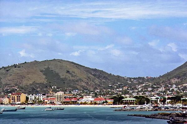
A view of the capital of Charlotte Amalie on Saint Thomas. The port city's deepwater harbor was once a haven for pirates. Today, it is a famed cruise ship port of call.
A view of the capital of Charlotte Amalie on Saint Thomas. The port city's deepwater harbor was once a haven for pirates. Today, it is a famed cruise ship port of call. • CIA World Factbook • 2020
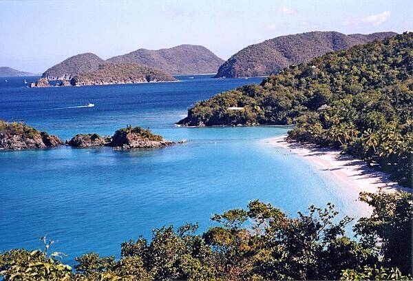
Trunk Bay on Saint John; its beach, considered one of the Caribbean's most beautiful, even features an underwater trail.
Trunk Bay on Saint John; its beach, considered one of the Caribbean's most beautiful, even features an underwater trail. • CIA World Factbook • 2020
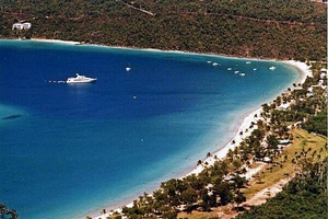
An anchored yacht off the island of Saint Thomas.
An anchored yacht off the island of Saint Thomas. • CIA World Factbook • 2020
CIA World Factbook • 2020
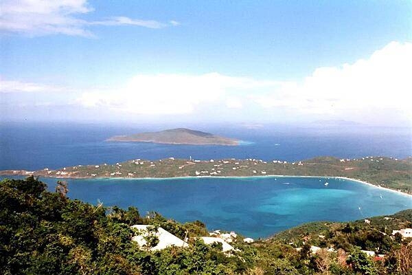
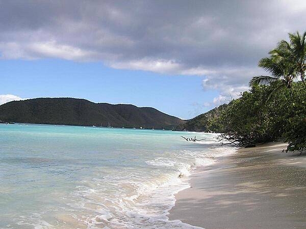
A view of Saint Thomas Bay.
A view of Saint Thomas Bay. • CIA World Factbook • 2020
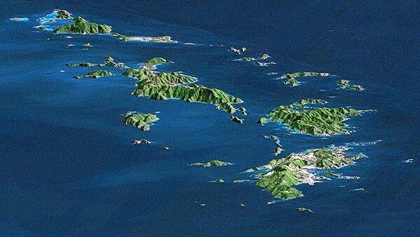
Saint Thomas, Saint John, Tortola, and Virgin Gorda are the four main islands (front to back) in this east-looking view of the US Virgin Islands and British Virgin Islands. For this view, a nearly cloud-free Landsat image was draped over radar elevation data, and shading was added to enhance the topographic expression. Elevation is shown with 1.5x scaled vertical exaggeration. Coral reefs fringe the islands in many locations and appear as very light shades of blue. Tropical vegetation appears green, while developed areas appear in shades of brown and white. Image credit: NASA, JPL, and NIMA.
Saint Thomas, Saint John, Tortola, and Virgin Gorda are the four main islands (front to back) in this east-looking view of the US Virgin Islands and British Virgin Islands. For this view, a nearly cloud-free Landsat image was draped over radar elevation data, and shading was added to enhance the topographic expression. Elevation is shown with 1.5x scaled vertical exaggeration. Coral reefs fringe the islands in many locations and appear as very light shades of blue. Tropical vegetation appears green, while developed areas appear in shades of brown and white. Image credit: NASA, JPL, and NIMA. • CIA World Factbook • 2020
8 photos available
View All Photos→Data sources: World Bank, UN Data • Updated daily •Learn about our data